File:Canada topo.jpg
ნავიგაციაზე გადასვლა
ძიებაზე გადასვლა
ზომა წინასწარი გადახედვისას: 693 × 599 პიქსელი. სხვა გაფართოება: 278 × 240 პიქსელი | 555 × 480 პიქსელი | 888 × 768 პიქსელი | 1 184 × 1 024 პიქსელი | 1 400 × 1 211 პიქსელი.
თავდაპირველი ფაილი (1 400 × 1 211 პიქსელი, ფაილის ზომა: 791 კბ, MIME ტიპი: image/jpeg)
Captions
Captions
Add a one-line explanation of what this file represents
Hhhdndicidm
რეზიუმე[რედაქტირება]
| აღწერა |
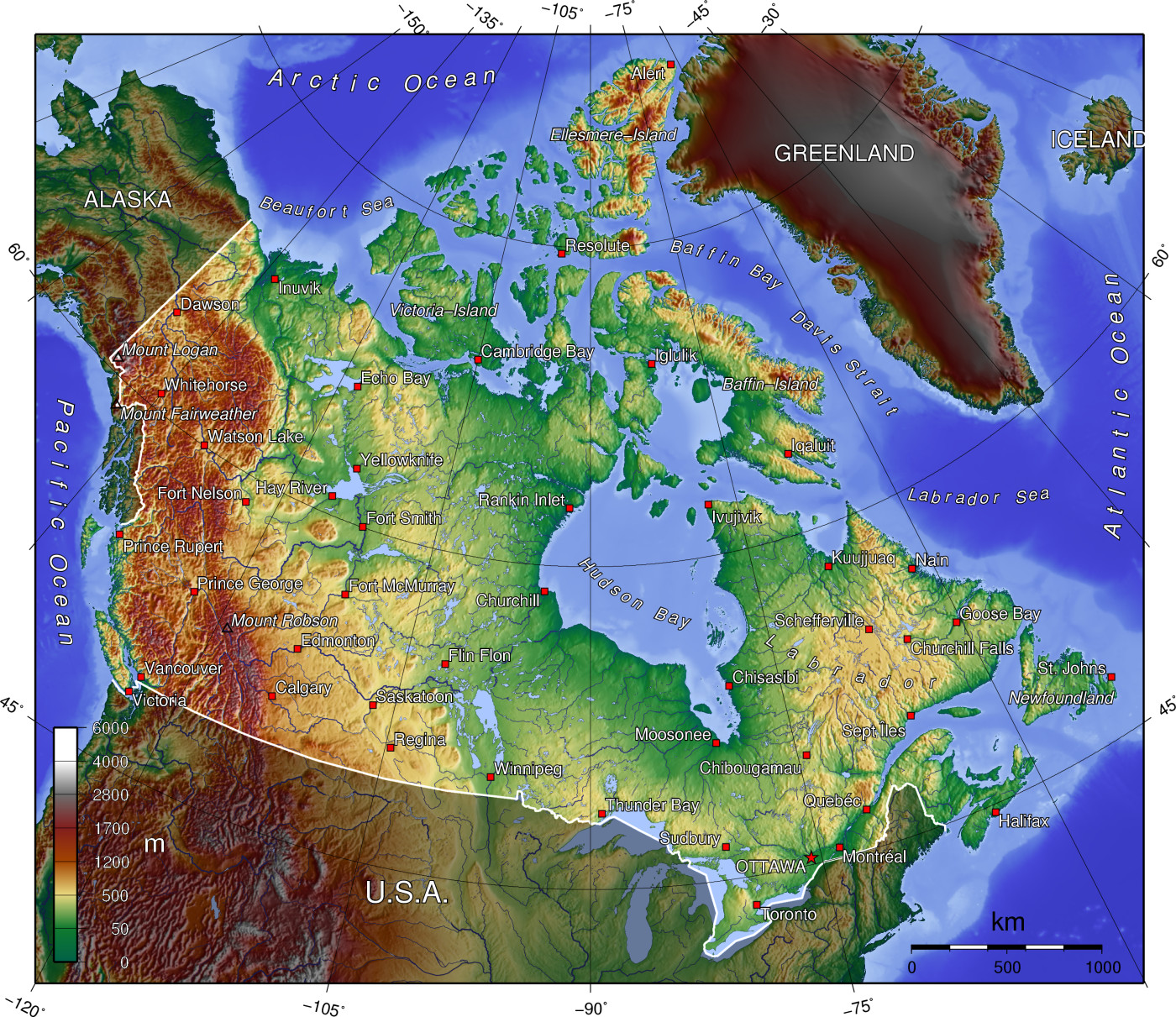
A topographic map of Canada, in polar projection (for 90° W), showing elevations shaded from green to brown (higher), with elevation-legend overlaid at lower left. Nearby countries are shaded darker (compare elevation shades at Canadian borders). The image is centered over longitude 90° W, with longitude meridians at 15-degree intervals apart, and latitude parallels also 15-degree. The boundaries are roughly from longitude 10°W to 177°W, and latitude 40°N to 84°N (above northern-most Alert, Canada 82°28′N, 62°30′W). |
| თარიღი | 14-April-2006 (English Wikipedia image of 7-July-2005) |
| წყარო | From English Wikipedia image of 7-July-2005, same name: en:Image:Canada topo.jpg (which now points here to Commons). |
| ავტორი | User:Anchjo (from en:Wikipedia User:Captain_Blood) |
| სხვა ვერსიები | Derivative works of this file: Dawson Route topo.jpg |
ლიცენზია[რედაქტირება]
The map has been created with the Generic Mapping Tools: https://www.generic-mapping-tools.org/ using one or more of these public-domain datasets for the relief:
|

|
თქვენ შეგიძიათ გაავრცელოთ ან შეცვალოთ დოკუმენტი GNU Free Documentation ლიცენზიის 1.2 ან უფრო გვიანდელი ვერსიის პირობების თანახმად, რომელიც გამოქვეყნებულია თავისუფალი პროგრამული უზრუნველყოფის ფონდის მიერ, შეუცვლელი განყოფილებების გარეშე, პირველ და ბოლო გვერდებზე განთავსებულ ტექსტებზე. ლიცენზიის ასლი არის განთავსებული განყოფილებაში სახელად GNU Free Documentation License. |
| ეს ნამუშევარი ვრცელდება Creative Commons Attribution-Share Alike 3.0 Unported ლიცენზიით. | ||
| ||
| ეს ლიცენზირების ნიშანი დაემატა ამ ფაილს, როგორც GFDL ლიცენზიის განახლების ნაწილი. |
ატვირთვის ჟურნალი[რედაქტირება]
- http://upload.wikimedia.org/wikipedia/en/d/d7/Canada topo.jpg[dead link] (14:36, 7 July 2005) . . User:Captain Blood (Captain Blood) (User talk:Captain Blood (Talk) ) . . 1400x1211 (810081 bytes) ({GMT})
ფაილის ისტორია
დააწკაპუნეთ თარიღზე/დროზე, რათა იხილოთ ფაილი, როგორც ის მაშინ გამოიყურებოდა.
| თარიღი/დრო | მინიატიურა | განზომილებები | მომხმარებელი | კომენტარი | |
|---|---|---|---|---|---|
| მიმდინარე | 14:22, 14 აპრილი 2006 | | 1 400 × 1 211 (791 კბ) | Anchjo (განხილვა | წვლილი) | '''This file was transfered from [http://en.wikipedia.org en.wikipedia.org]. The original file description page is (was) here.''' == Original description at [http://en.wikipedia.org en] == {{GFDL-GMT}} [[:de:Bild:Kanada_topo |
თქვენ არ შეგიძლიათ ამ ფაილზე გადაწერა.
ფაილის გამოყენება
მომდევნო გვერდები იყენებენ ამ ფაილს:
-R2.jpg)
ფაილის გლობალური გამოყენება
ეს ფაილი გამოიყენება შემდეგ ვიკებში:
- გამოყენება an.wikipedia.org-ში
- გამოყენება ar.wikipedia.org-ში
- გამოყენება bg.wikipedia.org-ში
- გამოყენება de.wikipedia.org-ში
- გამოყენება en.wikipedia.org-ში
- Talk:British Columbia
- Talk:Burgess Shale
- Geography of Canada
- Talk:Columbia River
- Talk:Newfoundland and Labrador
- Talk:Rocky Mountains
- Talk:Vinland
- Talk:Great Lakes
- Talk:Nunavut
- Talk:Muskeg
- Talk:Ellesmere Island
- Talk:St. Lawrence River
- Talk:Island of Montreal
- Talk:Provinces and territories of Canada
- Talk:Northern Canada
- Talk:Montreal
- Talk:Prince Edward Island
- Talk:Alberta
- Talk:Arctic Circle
- Talk:Emerald Park, Saskatchewan
- Talk:Cascade Range
- Talk:St. John's, Newfoundland and Labrador
- Talk:Citadel Hill (Fort George)
- Talk:List of communities in Quebec
- Talk:List of cities in Canada
- Talk:Nunavik
- Talk:Belcher Islands
- Talk:Carleton Place
- Talk:Beringia
- Talk:Quebec
- Talk:Plains of Abraham
- Talk:List of Hudson Bay rivers
- Talk:Yukon
- Talk:Inuvik
- Talk:Proposal for the Province of Toronto
- Talk:New Brunswick
- Talk:Surrey, British Columbia
- Talk:List of communities in Nova Scotia
- Talk:Greater Toronto Area
- Talk:Richmond County, Nova Scotia
- Talk:Lake Erie
- Talk:St. Marys River (Michigan–Ontario)
- Talk:100 Mile House
იხილეთ, ამ ფაილის გლობალური გამოყენება.