File:Canada topo.jpg
跳转到导航
跳转到搜索
本预览的尺寸:693 × 599像素。 其他分辨率:278 × 240像素 | 555 × 480像素 | 888 × 768像素 | 1,184 × 1,024像素 | 1,400 × 1,211像素。
原始文件 (1,400 × 1,211像素,文件大小:791 KB,MIME类型:image/jpeg)
说明
说明
添加一行文字以描述该文件所表现的内容
Hhhdndicidm
摘要
[编辑]
| 描述 |
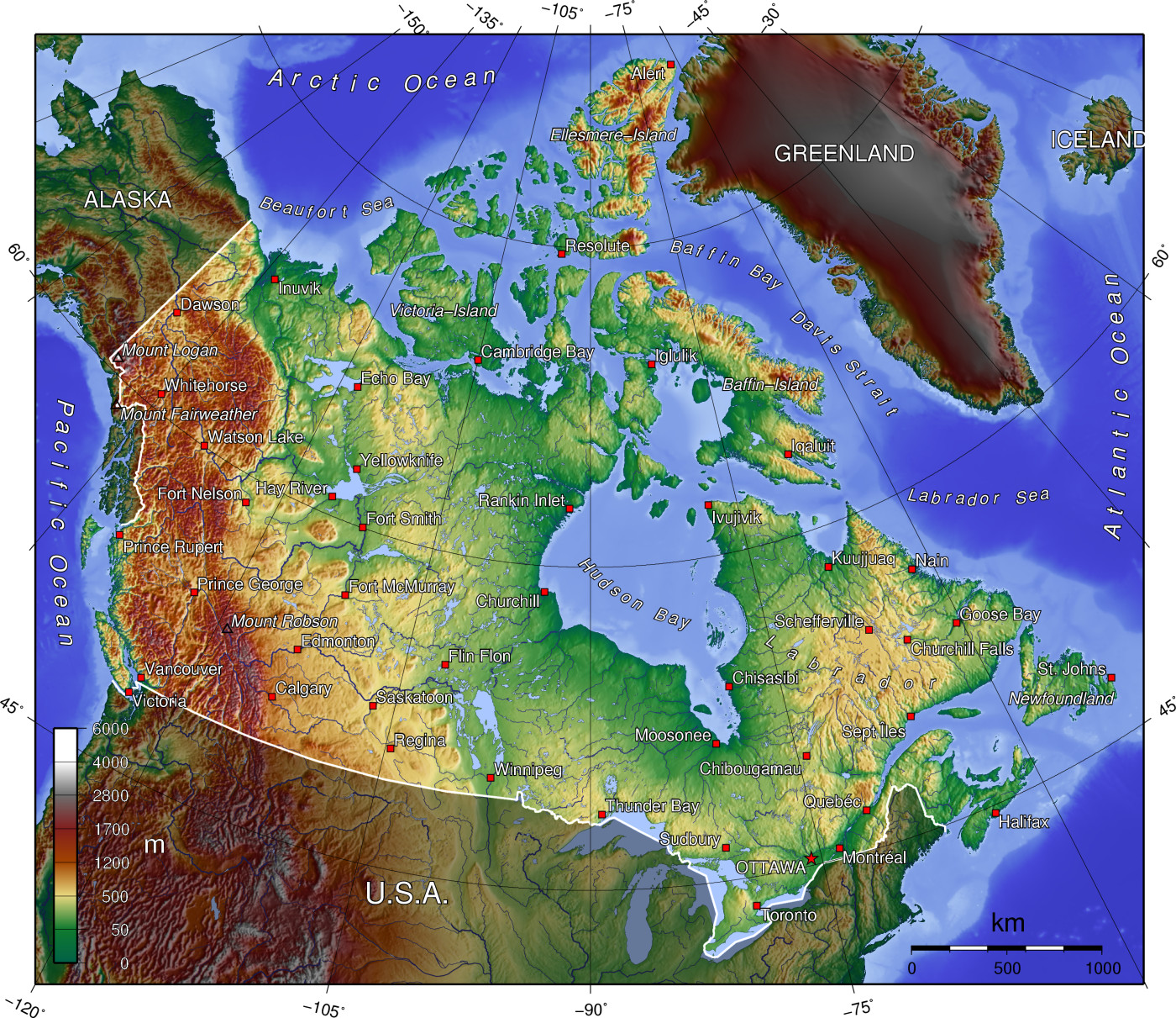
A topographic map of Canada, in polar projection (for 90° W), showing elevations shaded from green to brown (higher), with elevation-legend overlaid at lower left. Nearby countries are shaded darker (compare elevation shades at Canadian borders). The image is centered over longitude 90° W, with longitude meridians at 15-degree intervals apart, and latitude parallels also 15-degree. The boundaries are roughly from longitude 10°W to 177°W, and latitude 40°N to 84°N (above northern-most Alert, Canada 82°28′N, 62°30′W). |
| 日期 | 14-April-2006 (English Wikipedia image of 7-July-2005) |
| 来源 | From English Wikipedia image of 7-July-2005, same name: en:Image:Canada topo.jpg (which now points here to Commons). |
| 作者 | User:Anchjo (from en:Wikipedia User:Captain_Blood) |
| 其他版本 | Derivative works of this file: Dawson Route topo.jpg |
许可协议
[编辑]
该地图是使用通用制图工具创建的: https://www.generic-mapping-tools.org/ 使用其中一个或多个公有领域浮雕数据集:
|

|
已授权您依据自由软件基金会发行的无固定段落及封面封底文字(Invariant Sections, Front-Cover Texts, and Back-Cover Texts)的GNU自由文件许可协议1.2版或任意后续版本的条款,复制、传播和/或修改本文件。该协议的副本请见“GNU Free Documentation License”。 |
| 本文件采用知识共享署名-相同方式共享 3.0 未本地化版本许可协议授权。 | ||
| ||
| 本许可协议标签作为GFDL许可协议更新的组成部分被添加至本文件。 |
原始上传日志
[编辑]
- http://upload.wikimedia.org/wikipedia/en/d/d7/Canada topo.jpg[失效链接] (14:36, 7 July 2005) . . User:Captain Blood (Captain Blood) (User talk:Captain Blood (Talk) ) . . 1400x1211 (810081 bytes) ({GMT})
文件历史
点击某个日期/时间查看对应时刻的文件。
| 日期/时间 | 缩略图 | 大小 | 用户 | 备注 | |
|---|---|---|---|---|---|
| 当前 | 2006年4月14日 (五) 14:22 | | 1,400 × 1,211(791 KB) | Anchjo(留言 | 贡献) | '''This file was transfered from [http://en.wikipedia.org en.wikipedia.org]. The original file description page is (was) here.''' == Original description at [http://en.wikipedia.org en] == {{GFDL-GMT}} [[:de:Bild:Kanada_topo |
您不可以覆盖此文件。
文件用途
以下5个页面使用本文件:
-R2.jpg)
全域文件用途
以下其他wiki使用此文件:
- an.wikipedia.org上的用途
- ar.wikipedia.org上的用途
- bg.wikipedia.org上的用途
- de.wikipedia.org上的用途
- en.wikipedia.org上的用途
- Talk:British Columbia
- Talk:Burgess Shale
- Geography of Canada
- Talk:Columbia River
- Talk:Newfoundland and Labrador
- Talk:Rocky Mountains
- Talk:Vinland
- Talk:Great Lakes
- Talk:Nunavut
- Talk:Muskeg
- Talk:Ellesmere Island
- Talk:St. Lawrence River
- Talk:Island of Montreal
- Talk:Provinces and territories of Canada
- Talk:Northern Canada
- Talk:Montreal
- Talk:Prince Edward Island
- Talk:Alberta
- Talk:Arctic Circle
- Talk:Emerald Park, Saskatchewan
- Talk:Cascade Range
- Talk:St. John's, Newfoundland and Labrador
- Talk:Citadel Hill (Fort George)
- Talk:List of communities in Quebec
- Talk:List of cities in Canada
- Talk:Nunavik
- Talk:Belcher Islands
- Talk:Carleton Place
- Talk:Beringia
- Talk:Quebec
- Talk:Plains of Abraham
- Talk:List of Hudson Bay rivers
- Talk:Yukon
- Talk:Inuvik
- Talk:Proposal for the Province of Toronto
- Talk:New Brunswick
- Talk:Surrey, British Columbia
- Talk:List of communities in Nova Scotia
- Talk:Greater Toronto Area
- Talk:Richmond County, Nova Scotia
- Talk:Lake Erie
- Talk:St. Marys River (Michigan–Ontario)
- Talk:100 Mile House
查看此文件的更多全域用途。