File:Capital Beltway Map Color.svg
跳至導覽
跳至搜尋

此 SVG 檔案的 PNG 預覽的大小:564 × 489 像素。 其他解析度:277 × 240 像素 | 554 × 480 像素 | 886 × 768 像素 | 1,181 × 1,024 像素 | 2,362 × 2,048 像素。
原始檔案 (SVG 檔案,表面大小:564 × 489 像素,檔案大小:279 KB)
說明
說明
添加單行說明來描述出檔案所代表的內容
摘要
[編輯]
| 描述 |
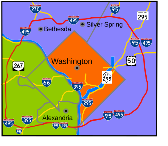
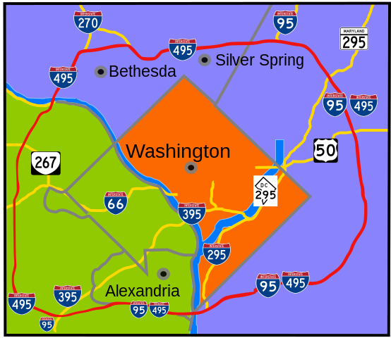
English: Interstate 495 in the state of Maryland and Commonwealth of Virginia in red surrounds the District of Columbia like a "belt", hence the name. |
| 日期 | |
| 來源 | 自己的作品 |
| 作者 | based on Image:Capital Beltway Map Color.png by Squiggygfm |
授權條款
[編輯]
| 我,此作品的版權所有人,釋出此作品至公共領域。此授權條款在全世界均適用。 這可能在某些國家不合法,如果是的話: 我授予任何人有權利使用此作品於任何用途,除受法律約束外,不受任何限制。 |
檔案歷史
點選日期/時間以檢視該時間的檔案版本。
| 日期/時間 | 縮圖 | 尺寸 | 用戶 | 備註 | |
|---|---|---|---|---|---|
| 目前 | 2008年3月23日 (日) 20:49 | | 564 × 489(279 KB) | RTCNCA(對話 | 貢獻) | Adjust interstate shields to mark I-95 south of beltway, portion of beltway between 95 and Woodrow Wilson bridge, mark 395 more clearly |
| 2007年11月30日 (五) 21:44 |  | 564 × 489(241 KB) | Rfc1394(對話 | 貢獻) | Fix more minor format and placement errors either I should have seen before or didn't notice until after uploaded | |
| 2007年11月30日 (五) 21:35 |  | 564 × 489(243 KB) | Rfc1394(對話 | 貢獻) | Slight adjustment to move label "Silver Spring" above the dividing line | |
| 2007年11月30日 (五) 21:33 |  | 564 × 489(241 KB) | Rfc1394(對話 | 貢獻) | == Summary == {{Information |Description= Interstate 495 in the state of Maryland and Commonwealth of Virgina in red surrounds the District of Columbia like a "belt", hence the name. |Source=own work |Date= April 26, 2007 |Author= based on [[:Image:Capi |
無法覆蓋此檔案。
檔案用途
全域檔案使用狀況
以下其他 wiki 使用了這個檔案:
- da.wikipedia.org 的使用狀況
- de.wikipedia.org 的使用狀況
- en.wikipedia.org 的使用狀況
- en.wikibooks.org 的使用狀況
- es.wikipedia.org 的使用狀況
- fr.wikipedia.org 的使用狀況
- ja.wikipedia.org 的使用狀況
- sv.wikipedia.org 的使用狀況
- www.wikidata.org 的使用狀況
- zh.wikipedia.org 的使用狀況