File:Carolinacolony.png
跳至導覽
跳至搜尋
預覽大小:572 × 599 像素。 其他解析度:229 × 240 像素 | 458 × 480 像素 | 1,000 × 1,048 像素。
原始檔案 (1,000 × 1,048 像素,檔案大小:419 KB,MIME 類型:image/png)
說明
說明
添加單行說明來描述出檔案所代表的內容
摘要
[編輯]

|
本圖片是以PNG、GIF或JPEG格式上傳。然而,其中包含的資料或訊息,應該重新建立成可縮放向量圖形(SVG)檔案,以更有效率或更準確的方式儲存。如有可能,請上傳本圖片的SVG格式版本。在上傳之後,請修改維基各姊妹計畫中所有使用舊版圖片的條目(列在圖像連結章節中),替換為新版圖片,並在舊圖片的描述頁中加入{{Vector version available|新圖片名稱.svg}}模板,同時移除本模板。
|
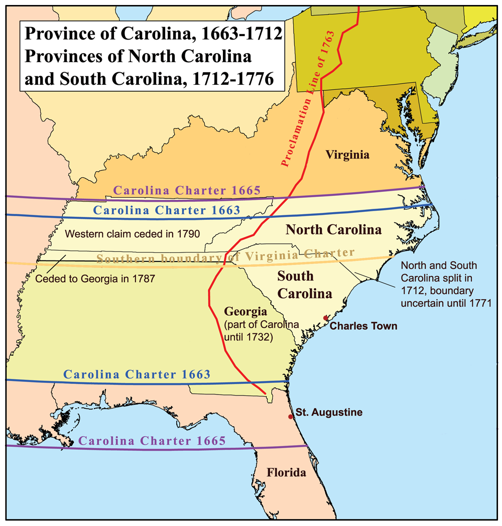
This is a map of the Province of Carolina that I made. Boundary disputes between colonies not involving Carolina are not shown.
授權條款
[編輯]
我,本作品的著作權持有者,決定用以下授權條款發佈本作品:
此檔案採用創用CC 姓名標示-相同方式分享 2.5 通用版授權條款。
- 您可以自由:
- 分享 – 複製、發佈和傳播本作品
- 重新修改 – 創作演繹作品
- 惟需遵照下列條件:
- 姓名標示 – 您必須指名出正確的製作者,和提供授權條款的連結,以及表示是否有對內容上做出變更。您可以用任何合理的方式來行動,但不得以任何方式表明授權條款是對您許可或是由您所使用。
- 相同方式分享 – 如果您利用本素材進行再混合、轉換或創作,您必須基於如同原先的相同或兼容的條款,來分布您的貢獻成品。
檔案歷史
點選日期/時間以檢視該時間的檔案版本。
| 日期/時間 | 縮圖 | 尺寸 | 用戶 | 備註 | |
|---|---|---|---|---|---|
| 目前 | 2013年6月21日 (五) 17:22 | | 1,000 × 1,048(419 KB) | Kmusser(對話 | 貢獻) | 1729 corrected to 1712 |
| 2006年11月16日 (四) 21:32 |  | 500 × 524(96 KB) | Kmusser(對話 | 貢獻) | This is a map of the Province of Carolina that I made. Boundary disputes between colonies not involving Carolina are not shown. == Licensing == {{self|cc-by-sa-2.5}} Category:Maps of disputed territories [[Category:Maps |
無法覆蓋此檔案。
檔案用途
沒有使用此檔案的頁面。
全域檔案使用狀況
以下其他 wiki 使用了這個檔案:
- ar.wikipedia.org 的使用狀況
- ca.wikipedia.org 的使用狀況
- cs.wikipedia.org 的使用狀況
- de.wikipedia.org 的使用狀況
- en.wikipedia.org 的使用狀況
- es.wikipedia.org 的使用狀況
- fi.wikipedia.org 的使用狀況
- fr.wikipedia.org 的使用狀況
- fr.wiktionary.org 的使用狀況
- he.wikipedia.org 的使用狀況
- id.wikipedia.org 的使用狀況
- it.wikipedia.org 的使用狀況
- ja.wikipedia.org 的使用狀況
- ko.wikipedia.org 的使用狀況
- la.wikipedia.org 的使用狀況
- nl.wikipedia.org 的使用狀況
- nn.wikipedia.org 的使用狀況
- no.wikipedia.org 的使用狀況
- oc.wikipedia.org 的使用狀況
- pl.wikipedia.org 的使用狀況
檢視此檔案的更多全域使用狀況。
詮釋資料
分類:
- Maps of disputed territories in North America
- Maps of the Thirteen Colonies
- Province of Carolina
- Maps of the history of colonies of the United Kingdom
- Maps of the history of North Carolina
- Maps of the history of South Carolina
- Maps of the history of Georgia (U.S. state)
- Royal Proclamation of 1763
- 1732 in Georgia (U.S. state)
- Province of Georgia
- Carolina Charter
- North Carolina-South Carolina border
- Georgia-South Carolina border
- State borders of Georgia (U.S. state)
- North Carolina-Virginia border
- State borders of Florida