File:Carolinacolony.png
跳转到导航
跳转到搜索
本预览的尺寸:572 × 599像素。 其他分辨率:229 × 240像素 | 458 × 480像素 | 1,000 × 1,048像素。
原始文件 (1,000 × 1,048像素,文件大小:419 KB,MIME类型:image/png)
说明
说明
添加一行文字以描述该文件所表现的内容
摘要
[编辑]

|
此historical map图片可使用矢量图形重新创建为SVG文件。这具有很多好处;更多信息请参见共享资源:待清理媒体。如果存在此图片的SVG格式,请将其上传,然后将此模板替换为
{{vector version available|新图片名称}}。
建议您将SVG命名为“Carolinacolony.svg”,这样在使用Vector version available(或Vva)模板时就不需要填写新图片名称参数。 |
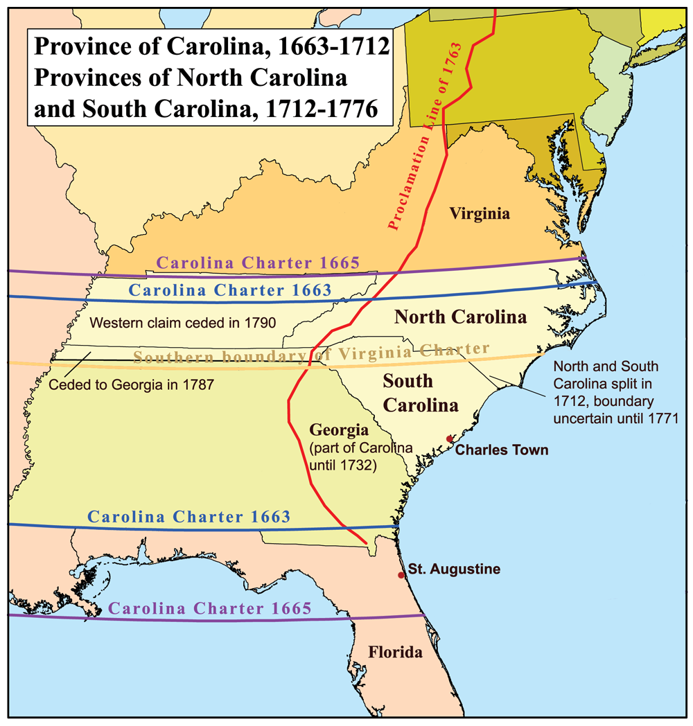
This is a map of the Province of Carolina that I made. Boundary disputes between colonies not involving Carolina are not shown.
许可协议
[编辑]
我,本作品著作权人,特此采用以下许可协议发表本作品:
本文件采用知识共享署名-相同方式共享 2.5 通用许可协议授权。
- 您可以自由地:
- 共享 – 复制、发行并传播本作品
- 修改 – 改编作品
- 惟须遵守下列条件:
- 署名 – 您必须对作品进行署名,提供授权条款的链接,并说明是否对原始内容进行了更改。您可以用任何合理的方式来署名,但不得以任何方式表明许可人认可您或您的使用。
- 相同方式共享 – 如果您再混合、转换或者基于本作品进行创作,您必须以与原先许可协议相同或相兼容的许可协议分发您贡献的作品。
文件历史
点击某个日期/时间查看对应时刻的文件。
| 日期/时间 | 缩略图 | 大小 | 用户 | 备注 | |
|---|---|---|---|---|---|
| 当前 | 2013年6月21日 (五) 17:22 | | 1,000 × 1,048(419 KB) | Kmusser(留言 | 贡献) | 1729 corrected to 1712 |
| 2006年11月16日 (四) 21:32 |  | 500 × 524(96 KB) | Kmusser(留言 | 贡献) | This is a map of the Province of Carolina that I made. Boundary disputes between colonies not involving Carolina are not shown. == Licensing == {{self|cc-by-sa-2.5}} Category:Maps of disputed territories [[Category:Maps |
您不可以覆盖此文件。
文件用途
没有页面使用本文件。
全域文件用途
以下其他wiki使用此文件:
- ar.wikipedia.org上的用途
- ca.wikipedia.org上的用途
- cs.wikipedia.org上的用途
- de.wikipedia.org上的用途
- en.wikipedia.org上的用途
- es.wikipedia.org上的用途
- fi.wikipedia.org上的用途
- fr.wikipedia.org上的用途
- fr.wiktionary.org上的用途
- he.wikipedia.org上的用途
- id.wikipedia.org上的用途
- it.wikipedia.org上的用途
- ja.wikipedia.org上的用途
- ko.wikipedia.org上的用途
- la.wikipedia.org上的用途
- nl.wikipedia.org上的用途
- nn.wikipedia.org上的用途
- no.wikipedia.org上的用途
- oc.wikipedia.org上的用途
- pl.wikipedia.org上的用途
查看此文件的更多全域用途。
元数据
分类:
- Maps of disputed territories in North America
- Maps of the Thirteen Colonies
- Province of Carolina
- Maps of the history of colonies of the United Kingdom
- Maps of the history of North Carolina
- Maps of the history of South Carolina
- Maps of the history of Georgia (U.S. state)
- Royal Proclamation of 1763
- 1732 in Georgia (U.S. state)
- Province of Georgia
- Carolina Charter
- North Carolina-South Carolina border
- Georgia-South Carolina border
- State borders of Georgia (U.S. state)
- North Carolina-Virginia border
- State borders of Florida