File:Carpathians-satellite.jpg
Aller à la navigation
Aller à la recherche

Taille de cet aperçu : 624 × 599 pixels. Autres résolutions : 250 × 240 pixels | 500 × 480 pixels | 800 × 768 pixels | 1 066 × 1 024 pixels | 2 133 × 2 048 pixels | 2 625 × 2 521 pixels.
Fichier d’origine (2 625 × 2 521 pixels, taille du fichier : 2,6 Mio, type MIME : image/jpeg)
Légendes
Légendes
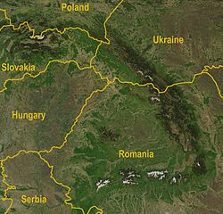
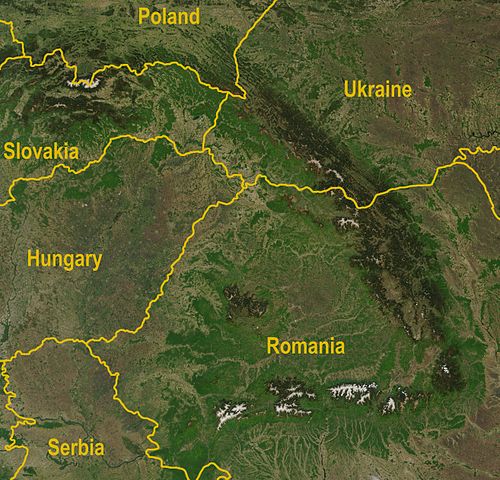
Image satellite des Carpates (la terminaison occidentale en est ici hors cadre).
Description[modifier]
| Description | A satellite map of the Carpathians |
| Date | |
| Source |
http://visibleearth.nasa.gov/view_rec.php?id=5348
|
| Auteur | Jeff Schmaltz, MODIS Rapid Response Team, NASA/GSFC |
| Autres versions | Image:Karpaty zdjęcie satelitarne.jpg |
Conditions d’utilisation[modifier]
| Ce fichier provient de la NASA. Sauf exception, les documents créés par la NASA ne sont pas soumis à copyright. Pour plus d'informations, voir la politique de copyright de la NASA. | ||
 |
Attention :
|
Historique du fichier
Cliquer sur une date et heure pour voir le fichier tel qu'il était à ce moment-là.
| Date et heure | Vignette | Dimensions | Utilisateur | Commentaire | |
|---|---|---|---|---|---|
| actuel | 30 août 2009 à 12:36 | | 2 625 × 2 521 (2,6 Mio) | Qorilla (d | contributions) | Better resolution, yellow country names |
| 18 avril 2005 à 18:47 |  | 434 × 413 (111 kio) | Bogdan (d | contributions) | A satellite map of the Carpathians Source: Created by NASA, modified by Bogdan Giuşcă {{GFDL}} Category:CarpathiansCategory:Maps of RomaniaCategory:Maps of UkraineCategory:Maps of Slovakia\ |
Vous ne pouvez pas remplacer ce fichier.
Utilisations locales du fichier
La page suivante utilise ce fichier :
Utilisations du fichier sur d’autres wikis
Les autres wikis suivants utilisent ce fichier :
- Utilisation sur af.wikipedia.org
- Utilisation sur ar.wikipedia.org
- Utilisation sur az.wikipedia.org
- Utilisation sur bg.wikipedia.org
- Utilisation sur br.wikipedia.org
- Utilisation sur ca.wikipedia.org
- Utilisation sur cy.wikipedia.org
- Utilisation sur el.wikipedia.org
- Utilisation sur en.wikipedia.org
- Utilisation sur fa.wikipedia.org
- Utilisation sur fi.wikipedia.org
- Utilisation sur fi.wikivoyage.org
- Utilisation sur fy.wikipedia.org
- Utilisation sur gl.wikipedia.org
- Utilisation sur he.wikipedia.org
- Utilisation sur hi.wikipedia.org
- Utilisation sur hu.wikipedia.org
- Utilisation sur hy.wikipedia.org
- Utilisation sur hyw.wikipedia.org
- Utilisation sur it.wikipedia.org
- Utilisation sur ja.wikipedia.org
- Utilisation sur ko.wikipedia.org
- Utilisation sur ky.wikipedia.org
- Utilisation sur lb.wikipedia.org
- Utilisation sur lv.wikipedia.org
- Utilisation sur ml.wikipedia.org
- Utilisation sur nl.wikipedia.org
- Utilisation sur nn.wikipedia.org
- Utilisation sur no.wikipedia.org
- Utilisation sur pa.wikipedia.org
- Utilisation sur pl.wikipedia.org
- Utilisation sur pl.wiktionary.org
- Utilisation sur pnb.wikipedia.org
- Utilisation sur pt.wikipedia.org
- Utilisation sur ro.wikipedia.org
- Utilisation sur scn.wikipedia.org
- Utilisation sur simple.wikipedia.org
- Utilisation sur sk.wikipedia.org
- Utilisation sur sl.wikipedia.org
- Utilisation sur sq.wikipedia.org
- Utilisation sur tt.wikipedia.org
- Utilisation sur uk.wikipedia.org
- Utilisation sur vi.wikipedia.org
- Utilisation sur yi.wikipedia.org
- Utilisation sur zh.wikipedia.org
Métadonnées
Catégories :
- Maps of the Carpathian Mountains
- Maps of mountain ranges of Europe
- Satellite pictures of Poland
- Satellite pictures of Slovakia
- Satellite maps of Ukraine
- Maps of Slovakia
- Maps of Romania
- Topographic maps of Serbia
- Maps of Hungary
- Maps of Eastern Europe
- Maps of Central Europe
- NASA MODIS images of Europe
- Poland-Slovakia border