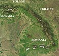
File:Carpathians-satellite.jpg
跳至導覽
跳至搜尋

預覽大小:624 × 599 像素。 其他解析度:250 × 240 像素 | 500 × 480 像素 | 800 × 768 像素 | 1,066 × 1,024 像素 | 2,133 × 2,048 像素 | 2,625 × 2,521 像素。
原始檔案 (2,625 × 2,521 像素,檔案大小:2.6 MB,MIME 類型:image/jpeg)
分類:
- Maps of the Carpathian Mountains
- Maps of mountain ranges of Europe
- Satellite pictures of Poland
- Satellite pictures of Slovakia
- Satellite maps of Ukraine
- Maps of Slovakia
- Maps of Romania
- Topographic maps of Serbia
- Maps of Hungary
- Maps of Eastern Europe
- Maps of Central Europe
- NASA MODIS images of Europe
- Poland-Slovakia border
- Satellite pictures of the Carpathian Mountains


