File:Carte Guerre de Sept Ans Europe.PNG
ナビゲーションに移動
検索に移動
このプレビューのサイズ: 800 × 582 ピクセル。 その他の解像度: 320 × 233 ピクセル | 640 × 466 ピクセル | 884 × 643 ピクセル。
元のファイル (884 × 643 ピクセル、ファイルサイズ: 77キロバイト、MIME タイプ: image/png)
キャプション
キャプション
このファイルの内容を1行で記述してください
Incorrect Information[編集]
- After the Russian-Swedisch war of 1741–1743 Finnland was russian in the East, up to the river Kymijoki, and Swedish in the western part. --El bes (talk) 21:02, 10 August 2008 (UTC)
An even bigger error here is that the UK, formed in 1707, is listed as England. Also, Ireland didn't join the Union until 1801, and at the time was still a kingdom in its own right.
Poland should be shown as the Polish-Lithuanian Commonwealth.
Austro-Ottoman borders shown here are actually from 1718-1739 period, between Treaty of Požarevac and Treaty of Belgrade

|
このhistorical map画像は、ベクターイメージである SVG ファイルとして再作成されるべきです。これにはいくつかの利点があります。詳しくはCommons:Media for cleanupを参照してください。この画像の SVG 形式がすでに利用可能である場合は、アップロードしてください。アップロード後、この画像にあるこのテンプレートを{{Vector version available|新しい画像ファイル名.svg}}テンプレートで置き換えてください。
|
概要[編集]
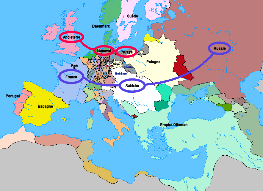
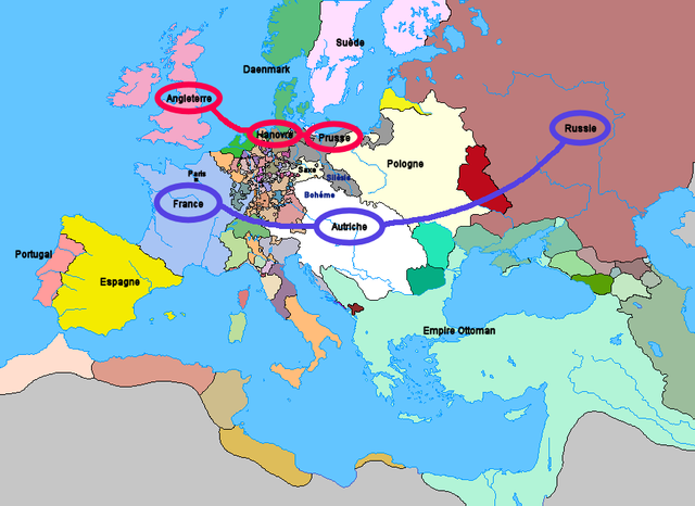
Carte de l'Europe et des alliances à la veille de la guerre de Sept Ans (1757)
ライセンス[編集]
アップロード: Wordelle
| この著作物の著作権者である私は、この著作物における権利を放棄しパブリックドメインとします。これは全世界で適用されます。 一部の国では、これが法的に可能ではない場合があります。その場合は、次のように宣言します。 私は、あらゆる人に対して、法により必要とされている条件を除き、如何なる条件も課すことなく、あらゆる目的のためにこの著作物を使用する権利を与えます。 |
コンピュータが読み取れる情報は提供されていませんが、投稿者自身による著作物だと推定されます(著作権の主張に基づく)
ファイルの履歴
過去の版のファイルを表示するには、その版の日時をクリックしてください。
| 日付と時刻 | サムネイル | 寸法 | 利用者 | コメント | |
|---|---|---|---|---|---|
| 現在の版 | 2012年1月1日 (日) 21:25 | | 884 × 643 (77キロバイト) | Artemis Dread (トーク | 投稿記録) | Republic of Ragusa |
| 2011年12月24日 (土) 22:19 |  | 884 × 643 (77キロバイト) | Artemis Dread (トーク | 投稿記録) | Prince-Bishopric of Montenegro | |
| 2011年9月18日 (日) 10:58 |  | 884 × 643 (77キロバイト) | Artemis Dread (トーク | 投稿記録) | Kingdom of Imereti and Kingdom of Kartli-Kakheti, minor changes | |
| 2011年9月17日 (土) 14:31 |  | 884 × 643 (76キロバイト) | Artemis Dread (トーク | 投稿記録) | Finland | |
| 2011年9月17日 (土) 13:15 |  | 884 × 643 (76キロバイト) | Artemis Dread (トーク | 投稿記録) | minor changes | |
| 2011年9月17日 (土) 12:17 |  | 884 × 643 (76キロバイト) | Artemis Dread (トーク | 投稿記録) | Duchy of Courland and Semigallia | |
| 2011年9月17日 (土) 11:13 |  | 884 × 643 (76キロバイト) | Artemis Dread (トーク | 投稿記録) | Cossack Hetmanate | |
| 2011年9月17日 (土) 10:36 |  | 884 × 643 (76キロバイト) | Artemis Dread (トーク | 投稿記録) | vassals of the Ottoman Empire | |
| 2006年10月18日 (水) 09:30 |  | 884 × 643 (72キロバイト) | Wordelle (トーク | 投稿記録) | Carte de l'Europe et des alliances à la veille de la guerre de Sept Ans (1757) |
このファイルは上書きできません。
ファイルの使用状況
以下のページがこのファイルを使用しています:
グローバルなファイル使用状況
以下に挙げる他のウィキがこの画像を使っています:
- af.wikipedia.org での使用状況
- ar.wikipedia.org での使用状況
- az.wikipedia.org での使用状況
- bg.wikipedia.org での使用状況
- br.wikipedia.org での使用状況
- ca.wikipedia.org での使用状況
- cs.wikipedia.org での使用状況
- de.wikipedia.org での使用状況
- el.wikipedia.org での使用状況
- en.wikipedia.org での使用状況
- Portal:Russia
- Military history of the Russian Empire
- Diplomatic Revolution
- Portal:Russia/Selected anniversaries
- Portal:Russia/Selected anniversaries/May
- Stately quadrille
- Wenzel Anton, Prince of Kaunitz-Rietberg
- History of the foreign relations of the United Kingdom
- User:Rjensen/International relations 1648-1814
- User:Falcaorib/Europe
- es.wikipedia.org での使用状況
- et.wikipedia.org での使用状況
- eu.wikipedia.org での使用状況
- fr.wikipedia.org での使用状況
- fr.wikiversity.org での使用状況
- he.wikipedia.org での使用状況
- hu.wikipedia.org での使用状況
- id.wikipedia.org での使用状況
- it.wikipedia.org での使用状況
- ja.wikipedia.org での使用状況
- la.wikipedia.org での使用状況
- lv.wikipedia.org での使用状況
- ms.wikipedia.org での使用状況
- nl.wikipedia.org での使用状況
- nn.wikipedia.org での使用状況
- no.wikipedia.org での使用状況
- ro.wikipedia.org での使用状況
- ru.wikipedia.org での使用状況
- sh.wikipedia.org での使用状況
- sr.wikipedia.org での使用状況
- sv.wikipedia.org での使用状況
- sw.wikipedia.org での使用状況
- th.wikipedia.org での使用状況
このファイルのグローバル使用状況を表示する。