File:Carte des Khanats du Caucase-19emeS.png
Μετάβαση στην πλοήγηση
Πήδηση στην αναζήτηση

Μέγεθος αυτής της προεπισκόπησης: 800 × 582 εικονοστοιχεία . Άλλες αναλύσεις: 320 × 233 εικονοστοιχεία | 640 × 466 εικονοστοιχεία | 1.024 × 745 εικονοστοιχεία | 1.280 × 931 εικονοστοιχεία | 2.560 × 1.862 εικονοστοιχεία | 3.118 × 2.268 εικονοστοιχεία.
Πρωτότυπο αρχείο (3.118 × 2.268 εικονοστοιχεία, μέγεθος αρχείου: 426 KB, τύπος MIME: image/png)
Λεζάντες
Λεζάντες
Δεν ορίστηκε λεζάντα
Σύνοψη
[επεξεργασία]| Περιγραφή |
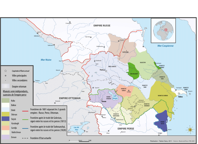
English: Map of caucasian khanates and struggle between persian and russian empire during the 19th century Français : Carte des Khanats du Caucase et de l'avancée russe dans le Caucase au XIXème siècle
|
| Ημερομηνία | |
| Πηγή | Έργο αυτού που το ανεβάζει, originally published on http://www.liranpourlesnuls.net/cartes/carte-les-khanats-independants-du-caucase-avant-le-xviiieme-s/ |
| Δημιουργός | Fabien Dany |
| Άδεια (Επαναχρησιμοποίηση αυτού του αρχείου) |
Français : L'utilisation est autorisée selon les termes ci-dessous et à condition de citer l'auteur et la source : www.liranpourlesnuls.net. Un email serait aussi grandement apprécié. |
| άλλες εκδόσεις |
.png)
Αδειοδότηση
[επεξεργασία]
Εγώ, ο κάτοχος των πνευματικών δικαιωμάτων αυτού του έργου, το δημοσιεύω δια του παρόντος υπό την εξής άδεια χρήσης:
Το αρχείο διανέμεται υπό την άδεια Creative Commons Αναφορά προέλευσης-Παρόμοια διανομή 3.0 Μη εισαγόμενη
- Είστε ελεύθερος:
- να μοιραστείτε – να αντιγράψετε, διανέμετε και να μεταδώσετε το έργο
- να διασκευάσετε – να τροποποιήσετε το έργο
- Υπό τις ακόλουθες προϋποθέσεις:
- αναφορά προέλευσης – Θα πρέπει να κάνετε κατάλληλη αναφορά, να παρέχετε σύνδεσμο για την άδεια και να επισημάνετε εάν έγιναν αλλαγές. Μπορείτε να το κάνετε με οποιοδήποτε αιτιολογήσιμο λόγο, χωρίς όμως να εννοείται με οποιονδήποτε τρόπο ότι εγκρίνουν εσάς ή τη χρήση του έργου από εσάς.
- παρόμοια διανομή – Εάν αλλάξετε, τροποποιήσετε ή δημιουργήσετε πάνω στο έργο αυτό, μπορείτε να διανείμετε αυτό που θα προκύψει μόνο υπό τους όρους της ίδιας ή συμβατής άδειας με το πρωτότυπο.
Ιστορικό αρχείου
Πατήστε σε μια ημερομηνία/ώρα για να δείτε το αρχείο όπως εμφανιζόταν εκείνη την χρονική στιγμή.
| Ημερομηνία/Ώρα | Μικρογραφία | Διαστάσεις | Χρήστης | Σχόλιο | |
|---|---|---|---|---|---|
| τρέχον | 21:34, 27 Ιανουαρίου 2012 | | 3.118 × 2.268 (426 KB) | Fadany (συζήτηση | Συνεισφορά) |
Δεν μπορείτε να αντικαταστήσετε αυτό το αρχείο.
Χρήση αρχείου
Οι ακόλουθες 2 σελίδες χρησιμοποιούν προς αυτό το αρχείο:
Καθολική χρήση αρχείου
Τα ακόλουθα άλλα wiki χρησιμοποιούν αυτό το αρχείο:
- Χρήση σε de.wikipedia.org
- Χρήση σε el.wikipedia.org
- Χρήση σε es.wikipedia.org
- Χρήση σε fr.wikipedia.org
- Χρήση σε pl.wikipedia.org
Μεταδεδομένα
Κατηγορίες:
- Maps of Khanates of the South Caucasus
- Maps of the history of Abkhazia
- PNG maps of the history of Azerbaijan
- Maps of the history of Naxçıvan
- Maps of the history of Kabardino-Balkaria
- Maps of the history of Karachay-Cherkessia
- Maps of the history of the south Caucasus region
- Maps of the history of Dagestan
- Maps of the history of Chechnya
- Maps of the history of Armenia
- Maps of the Caucasus by some users
- Khanate of Ganja