File:CarthageMapDe.png
Pāriet uz navigāciju
Pāriet uz meklēšanu
Augstāka izšķirtspēja nav pieejama.
CarthageMapDe.png (770 × 447 pikseļi, faila izmērs: 106 KB, MIME tips: image/png)
Captions
Captions
Pievieno vienas rindiņas aprakstu, ko šis fails attēlo
Kopsavilkums[labot šo sadaļu]
| Apraksts |
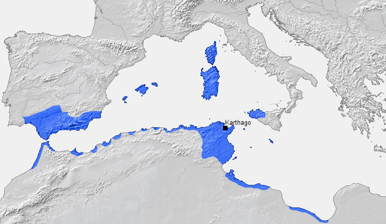
English: Location of Carthage and Carthaginian influence sphere before the First Punic War (264 BC) |
| Avots |
Paša darbs, based on Putzger Atlas und Chronik zur Weltgeschichte, Berlin, 2002 |
| Autors | BishkekRocks (diskusija · devums) |
Licence[labot šo sadaļu]
| I, the copyright holder of this work, release this work into the public domain. This applies worldwide. In some countries this may not be legally possible; if so: I grant anyone the right to use this work for any purpose, without any conditions, unless such conditions are required by law. |
Faila hronoloģija
Uzklikšķini uz datums/laiks kolonnā esošās saites, lai apskatītos, kā šis fails izskatījās tad.
| Datums/Laiks | Attēls | Izmēri | Dalībnieks | Komentārs | |
|---|---|---|---|---|---|
| tagadējais | 2006. gada 18. marts, plkst. 15.32 | | 770 × 447 (106 KB) | BishkekRocks (diskusija | devums) | Location of Carthage and Carthaginian influence sphere before the First Punic War (264 BC) Source: Self-made, based on Putzger Atlas und Chronik zur Weltgeschichte, Berlin, 2002 Template: [http://www.demis.nl/wms/mapclip.htm] Author: ~~~ [[Category:Ca |
Šo failu nevar pārrakstīt.
Faila lietojums
Šo failu izmanto šajā 1 lapā:
Globālais faila lietojums
Šīs Vikipēdijas izmanto šo failu:
- Izmantojums als.wikipedia.org
- Izmantojums ar.wikipedia.org
- Izmantojums ba.wikipedia.org
- Izmantojums be.wikipedia.org
- Izmantojums bg.wikipedia.org
- Izmantojums ca.wikipedia.org
- Izmantojums de.wikipedia.org
- Izmantojums de.wikibooks.org
- Izmantojums eo.wikipedia.org
- Izmantojums es.wikipedia.org
- Izmantojums fa.wikipedia.org
- Izmantojums fr.wikipedia.org
- Izmantojums fy.wikipedia.org
- Izmantojums ga.wikipedia.org
- Izmantojums hu.wikipedia.org
- Izmantojums hy.wikipedia.org
- Izmantojums id.wikipedia.org
- Izmantojums it.wikipedia.org
- Izmantojums ja.wikipedia.org
- Izmantojums ka.wikipedia.org
- Izmantojums ku.wikipedia.org
- Izmantojums la.wikipedia.org
- Izmantojums lt.wikipedia.org
- Izmantojums lv.wikipedia.org
- Izmantojums rm.wikipedia.org
- Izmantojums ru.wikipedia.org
- Izmantojums sh.wikipedia.org
- Izmantojums sk.wikipedia.org
- Izmantojums sl.wikipedia.org
- Izmantojums sr.wikipedia.org
- Izmantojums sw.wikipedia.org
- Izmantojums tt.wikipedia.org
- Izmantojums uk.wikipedia.org
Skatīt šī faila pilno globālo izmantojumu.