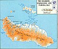
File:Casta-MAP Guadalcanal.jpg
Casta-MAP_Guadalcanal.jpg (538 × 452 píxels, mida del fitxer: 52 Ko, tipus MIME: image/jpeg)
Llegendes
Llegendes
Guadalcanal Island.
According to the University of Texas, "most of the maps scanned by the University of Texas Libraries and served from this web site are in the public domain. No permissions are needed to copy them. You may download them and use them as you wish. A few maps are copyrighted, and are clearly marked as such.". As the image, when downloaded from here was no tagged, the map is PD.
| Public domainPublic domainfalsefalse |
This file is in the public domain because it was put in PD by the University of Texas (from the Perry-Castaneda Library Map Collection hosted by http://www.lib.utexas.edu/maps/ - see above)
|
Historial del fitxer
Cliqueu una data/hora per veure el fitxer tal com era aleshores.
| Data/hora | Miniatura | Dimensions | Usuari/a | Comentari | |
|---|---|---|---|---|---|
| actual | 20:44, 6 nov 2010 |  | 538 × 452 (52 Ko) | Hohum (discussió | contribucions) | Cleaned |
| 20:32, 11 ago 2005 |  | 538 × 452 (38 Ko) | Bradipus (discussió | contribucions) | Guadalcanal Island. Maps from http://www.lib.utexas.edu/maps/ Public Domain (see http://navalhistory.flixco.info/H/118421x19817/8330/a0.htm) {{PD}} |
No podeu sobreescriure aquest fitxer.
Ús del fitxer
Les 15 pàgines següents utilitzen aquest fitxer:
- Actions along the Matanikau (September – October 1942)
- Battle for Henderson Field
- Battle of Edson's Ridge
- Battle of the Tenaru
- Cactus Air Force
- Carlson's Patrol
- Guadalcanal Campaign
- Invasion of Tulagi (May 1942)
- Solomon Islands campaign
- File:Casta-MAP Guadalcanal.png
- File:Casta-MAP Guadalcanal - it.jpg
- File:Guadalcanal & Florida Island map - fr.svg
- File:Guadalcanal & Florida Island map - mk.svg
- File:Solomon island - Guadalcanal - Florida map-ru.svg
- File:Solomon island - Guadalcanal - Florida map - en.svg
Ús global del fitxer
Utilització d'aquest fitxer en altres wikis:
- Utilització a ca.wikipedia.org
- Utilització a da.wikipedia.org
- Utilització a de.wikipedia.org
- Utilització a en.wikipedia.org
- Utilització a fr.wikipedia.org
- Utilització a he.wikipedia.org
- Utilització a id.wikipedia.org
- Utilització a it.wikipedia.org
- Utilització a pt.wikipedia.org
- Utilització a ro.wikipedia.org
- Utilització a ru.wikipedia.org
- Utilització a uk.wikipedia.org
Metadades
Aquest fitxer conté informació addicional, probablement afegida per la càmera digital o l'escàner utilitzat per a crear-lo o digitalitzar-lo. Si s'ha modificat posteriorment, alguns detalls poden no reflectir les dades reals del fitxer modificat.
| _error | 0 |
|---|
