File:Castelloplan.jpg
跳至導覽
跳至搜尋

預覽大小:800 × 588 像素。 其他解析度:320 × 235 像素 | 640 × 470 像素 | 1,024 × 753 像素 | 1,280 × 941 像素 | 2,560 × 1,881 像素 | 3,267 × 2,401 像素。
原始檔案 (3,267 × 2,401 像素,檔案大小:4.78 MB,MIME 類型:image/jpeg)
說明
說明
添加單行說明來描述出檔案所代表的內容
摘要[編輯]
| 描寫 |
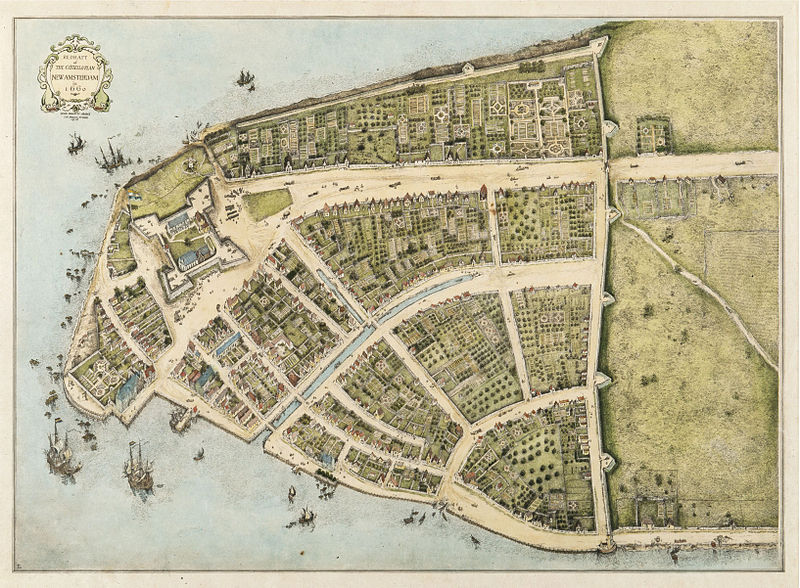
English: Redraft of the Castello Plan New Amsterdam in 1660. North is to the right.
31 x 40 cm Medium: printed map, color wash on paper العربية: خريطة نيو أمستردام في 1660
Español: Manhattan en 1660, cuando era parte de Nueva Amsterdam. El norte queda a la derecha. |
| 日期 | Drawn in 1916 |
| 來源 | New-York Historical Society Library, Maps Collection |
| 創作作者 |
John Wolcott Adams (1874–1925) and I.N. Phelps Stokes (1867–1944) |
| 授權許可 (重用此檔案) |
Published before January 1, 1923 in the United States, so it is eligible for PD-US. John Wolcott Adams died in 1925. Isaac Newton Phelps Stokes died in 1944. |
| 地理參考 | 如果不合適,請設定「warp_status = skip」為隱藏。 |
| 其他版本 |

|

_Castello_Plan_1660.jpg)
|
授權條款[編輯]
|
此為如實地拍攝平面藝術品的相片複製本。原作位於公有領域,是因下列原因:
維基媒體基金會的官方立場認為:「針對平面公有領域的藝術作品進行忠實重製,其重製後的照片也屬於公有領域。」
因此,可認定本重製照片屬於公有領域。在其他司法管轄區,再利用此照片可能會被限制;參見再利用PD-Art照片以獲得進一步資訊。 | ||||
檔案歷史
點選日期/時間以檢視該時間的檔案版本。
| 日期/時間 | 縮圖 | 尺寸 | 使用者 | 備註 | |
|---|---|---|---|---|---|
| 目前 | 2011年1月19日 (三) 22:02 | | 3,267 × 2,401(4.78 MB) | P. S. Burton(留言 | 貢獻) | higher resolution |
| 2007年5月9日 (三) 14:36 |  | 781 × 576(177 KB) | Maartenvdbent~commonswiki(留言 | 貢獻) | {{Information |Description=Redraft of the Castello Plan New Amsterdam in 1660<br>31 x 40 cm Medium: printed map, color wash on paper |Source=New York Historical Society [http://www.nyhistory.org/] |Date=Drawn in 1916 |Author=John Wolcott Adams and [[w:Is |
無法覆蓋此檔案。
檔案用途
下列4個頁面有用到此檔案:
全域檔案使用狀況
以下其他 wiki 使用了這個檔案:
- af.wikipedia.org 的使用狀況
- als.wikipedia.org 的使用狀況
- ar.wikipedia.org 的使用狀況
- ast.wikipedia.org 的使用狀況
- bn.wikipedia.org 的使用狀況
- br.wikipedia.org 的使用狀況
- ca.wikipedia.org 的使用狀況
- cs.wikipedia.org 的使用狀況
- da.wikipedia.org 的使用狀況
- de.wikipedia.org 的使用狀況
- el.wikipedia.org 的使用狀況
- en.wikipedia.org 的使用狀況
- New Amsterdam
- New York Harbor
- Colonial history of the United States
- Fort Amsterdam
- Portal:Netherlands
- Geography of New York City
- Wikipedia:WikiProject Urban studies and planning
- Environmental issues in New York City
- New York (state)
- Wikipedia:WikiProject Netherlands
- Castello Plan
- Wikipedia:Featured pictures/Diagrams, drawings, and maps/Maps
- Portal:Netherlands/Featured content
- List of New York City Designated Landmarks in Manhattan below 14th Street
- User talk:P. S. Burton/Archive 1
- Wikipedia:WikiProject United States/Recognized content
- Wikipedia:Featured pictures thumbs/26
- Timeline of town creation in Downstate New York
- Wikipedia:WikiProject United States/Quality content
- Wikipedia:Featured picture candidates/January-2011
- Wikipedia:Featured picture candidates/The Castello Plan
- Wikipedia:Wikipedia Signpost/2011-02-07/Features and admins
- User:Moonraker
- Wikipedia:Picture of the day/August 2012
- Template:POTD/2012-08-28
- Wikipedia:Main Page history/2012 August 28
檢視此檔案的更多全域使用狀況。