File:Caucasus 385 AD map de.png
Aller à la navigation
Aller à la recherche
Taille de cet aperçu : 771 × 599 pixels. Autres résolutions : 309 × 240 pixels | 618 × 480 pixels | 988 × 768 pixels | 1 280 × 995 pixels | 2 560 × 1 990 pixels | 3 000 × 2 332 pixels.
Fichier d’origine (3 000 × 2 332 pixels, taille du fichier : 3,54 Mio, type MIME : image/png)
Légendes
Légendes
Ajoutez en une ligne la description de ce que représente ce fichier
Description[modifier]
| Description |
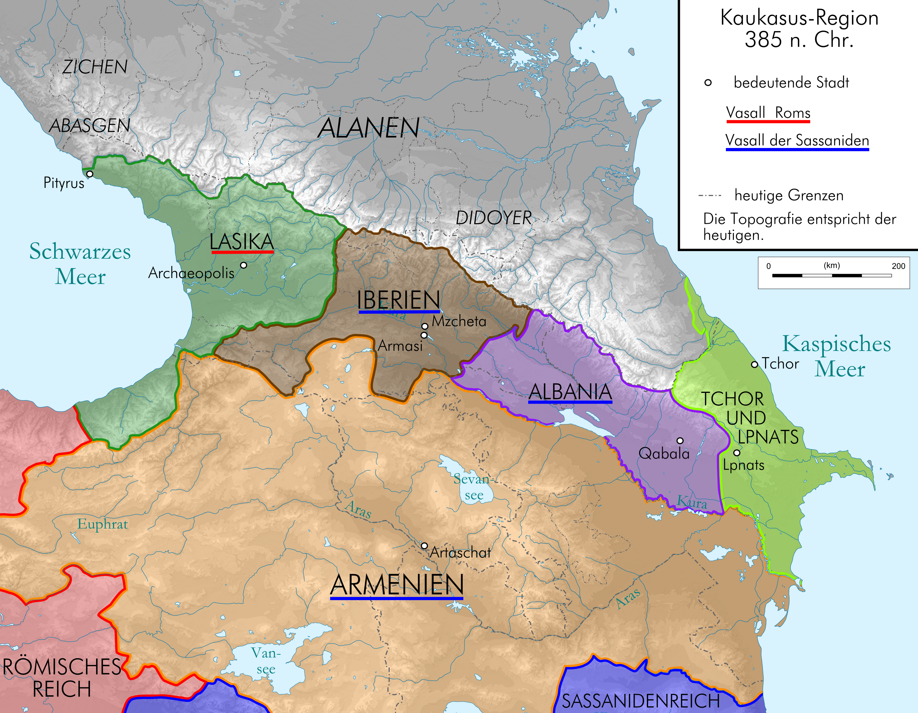
English: Map of Caucasus around 385 AC in German.
Deutsch: Kaukasus-Region um 300 n. Chr. Quellen sind File:Geor_earliest_2A.jpg , Putzger historischer Weltatlas Ausgabe 2005, Heinz Fähnrich: Geschichte Georgiens von den Anfängen bis zur Mongolenherrschaft. Shaker, Aachen 1993, ISBN 3-86111-683-9., http://www.armenica.org/cgi-bin/armenica.cgi?178711717323498=1=3==Armenia==1=3=AAA , Georgia in Antiquity - A History of Colchis and Transcaucasian Iberia by David Braund |
| Date | |
| Source | work by uploader, derivate of File:Caucasus_topographic_map-fr.svg |
| Auteur | Don-kun |
Conditions d’utilisation[modifier]
Moi, en tant que détenteur des droits d’auteur sur cette œuvre, je la publie sous les licences suivantes :
Ce fichier est disponible selon les termes de la licence Creative Commons Attribution – Partage dans les Mêmes Conditions 3.0 (non transposée).
- Vous êtes libre :
- de partager – de copier, distribuer et transmettre cette œuvre
- d’adapter – de modifier cette œuvre
- Sous les conditions suivantes :
- paternité – Vous devez donner les informations appropriées concernant l'auteur, fournir un lien vers la licence et indiquer si des modifications ont été faites. Vous pouvez faire cela par tout moyen raisonnable, mais en aucune façon suggérant que l’auteur vous soutient ou approuve l’utilisation que vous en faites.
- partage à l’identique – Si vous modifiez, transformez, ou vous basez sur cette œuvre, vous devez distribuer votre contribution sous la même licence ou une licence compatible avec celle de l’original.

|
Vous avez la permission de copier, distribuer et modifier ce document selon les termes de la GNU Free Documentation License version 1.2 ou toute version ultérieure publiée par la Free Software Foundation, sans sections inaltérables, sans texte de première page de couverture et sans texte de dernière page de couverture. Un exemplaire de la licence est inclus dans la section intitulée GNU Free Documentation License. |
Vous pouvez choisir l’une de ces licences.
Historique du fichier
Cliquer sur une date et heure pour voir le fichier tel qu'il était à ce moment-là.
| Date et heure | Vignette | Dimensions | Utilisateur | Commentaire | |
|---|---|---|---|---|---|
| actuel | 21 août 2009 à 10:26 | | 3 000 × 2 332 (3,54 Mio) | Don-kun (d | contributions) | {{Information |Description={{en|1=Map of Caucasus around 385 AC in German.}} {{de|1=Kaukasus-Region um 300 n. Chr. Quellen sind http://commons.wikimedia.org/wiki/File:Geor_earliest_2A.jpg , Putzger historischer Weltatlas Ausgabe 2005, Heinz Fähnrich: Ges |
Vous ne pouvez pas remplacer ce fichier.
Utilisations locales du fichier
Les 4 pages suivantes utilisent ce fichier :
Utilisations du fichier sur d’autres wikis
Les autres wikis suivants utilisent ce fichier :
- Utilisation sur als.wikipedia.org
- Utilisation sur de.wikipedia.org
- Utilisation sur fr.wikipedia.org
- Utilisation sur hr.wikipedia.org
- Utilisation sur lv.wikipedia.org
- Utilisation sur tr.wikipedia.org
Catégories :
- Maps of the history of Georgia
- Maps of the history of Armenia
- PNG maps of the history of Azerbaijan
- Maps of the history of the Caucasus in antiquity
- Maps of the history of Abkhazia
- Maps of the history of the south Caucasus region
- Maps of Caucasian Albania
- Maps of the Kingdom of Iberia
- Maps of Lazika
- Derivative maps of Putzgers Historischer Schul-Atlas