File:Caucasus 80 BC map de.png
Ir a la navegación
Ir a la búsqueda
Tamaño de esta previsualización: 771 × 599 píxeles. Otras resoluciones: 309 × 240 píxeles | 618 × 480 píxeles | 988 × 768 píxeles | 1280 × 995 píxeles | 2560 × 1990 píxeles | 2990 × 2324 píxeles.
Archivo original (2990 × 2324 píxeles; tamaño de archivo: 3,5 MB; tipo MIME: image/png)
Leyendas
Leyendas
Añade una explicación corta acerca de lo que representa este archivo
Resumen
[editar]
| Descripción |
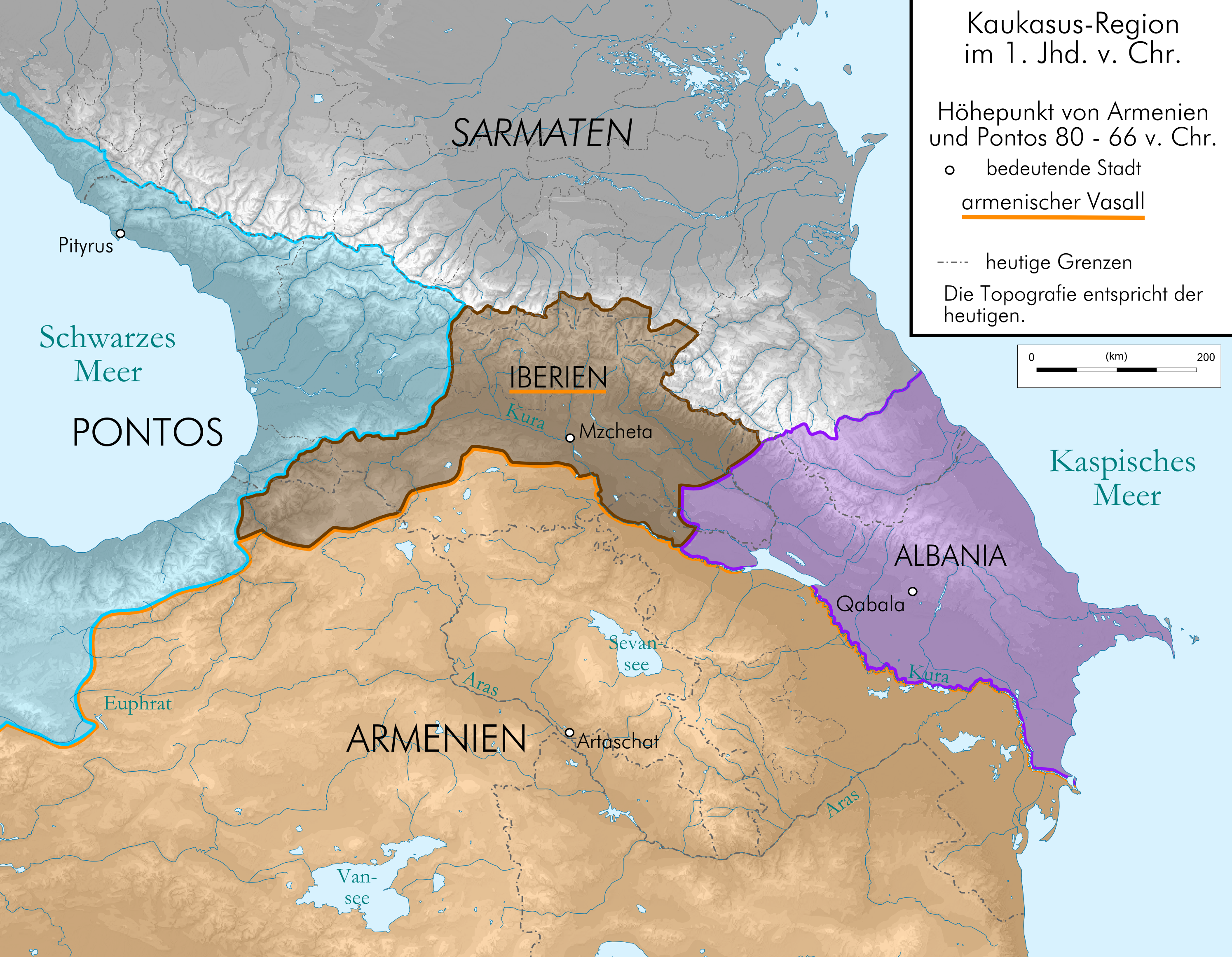
Deutsch: Kaukasus-Region um 80 v. Chr. Quellen sind File:Geor_earliest_2A.jpg , Putzger historischer Weltatlas Ausgabe 2005, http://www.armenica.org/cgi-bin/armenica.cgi?178711717323498=1=3==Armenia==1=3=AAA , Heinz Fähnrich: Geschichte Georgiens von den Anfängen bis zur Mongolenherrschaft. Shaker, Aachen 1993, ISBN 3-86111-683-9. |
| Fecha | |
| Fuente | Eigenes Werk (own work), derivate of File:Caucasus_topographic_map-fr.svg and File:Artaxiad Armenia 80BC-fr.svg |
| Autor | Don-kun, Bourrichon - fr:Bourrichon |
| Otras versiones |
 |
Licencia
[editar]
Yo, titular de los derechos de autor de esta obra, la publico en los términos de las siguientes licencias:

|
Se autoriza la copia, distribución y modificación de este documento bajo los términos de la licencia de documentación libre GNU, versión 1.2 o cualquier otra que posteriormente publique la Fundación para el Software Libre; sin secciones invariables, textos de portada, ni textos de contraportada. Se incluye una copia de la dicha licencia en la sección titulada Licencia de Documentación Libre GNU. |
Este archivo se encuentra bajo la licencia Creative Commons Attribution-Share Alike 3.0 Unported, 2.5 Generic, 2.0 Generic and 1.0 Generic
- Eres libre:
- de compartir – de copiar, distribuir y transmitir el trabajo
- de remezclar – de adaptar el trabajo
- Bajo las siguientes condiciones:
- atribución – Debes otorgar el crédito correspondiente, proporcionar un enlace a la licencia e indicar si realizaste algún cambio. Puedes hacerlo de cualquier manera razonable pero no de manera que sugiera que el licenciante te respalda a ti o al uso que hagas del trabajo.
- compartir igual – En caso de mezclar, transformar o modificar este trabajo, deberás distribuir el trabajo resultante bajo la misma licencia o una compatible como el original.
Puedes usar la licencia que prefieras.
Historial del archivo
Haz clic sobre una fecha y hora para ver el archivo tal como apareció en ese momento.
| Fecha y hora | Miniatura | Dimensiones | Usuario | Comentario | |
|---|---|---|---|---|---|
| actual | 18:12 23 ago 2009 | | 2990 × 2324 (3,5 MB) | Don-kun (discusión | contribs.) | cor, former source was Armenian Foreign Ministry, now armenica.org and Fähnrich |
| 11:23 8 ago 2009 |  | 3000 × 2332 (3,54 MB) | Don-kun (discusión | contribs.) | {{Information |Description={{de|1=Kaukasus-Region um 300 n. Chr. Quellen sind http://commons.wikimedia.org/wiki/File:Geor_earliest_2A.jpg , File:Artaxiad Armenia 80BC-fr.svg , Putzger historischer Weltatlas Ausgabe 2005, Heinz Fähnrich: Geschichte Georgi |
No puedes sobrescribir este archivo.
Usos del archivo
Las siguientes páginas usan este archivo:
Uso global del archivo
Las wikis siguientes utilizan este archivo:
- Uso en cs.wikipedia.org
- Uso en es.wikipedia.org
- Uso en ko.wikipedia.org
Categorías:
- Maps of the history of Georgia
- Maps of the history of Armenia
- PNG maps of the history of Azerbaijan
- Maps of the history of the Caucasus in antiquity
- Maps of the history of Abkhazia
- Maps of the history of the south Caucasus region
- Maps of Caucasian Albania
- Maps of the Kingdom of Iberia
- Derivative maps of Putzgers Historischer Schul-Atlas