File:Cenepa river basin.jpg
Salta a la navegació
Salta a la cerca
Mida d'aquesta previsualització: 476 × 600 píxels. Altres resolucions: 190 × 240 píxels | 381 × 480 píxels | 965 × 1.216 píxels.
Fitxer original (965 × 1.216 píxels, mida del fitxer: 900 Ko, tipus MIME: image/jpeg)
Llegendes
Llegendes
Afegeix una explicació d'una línia del que representa aquest fitxer
Resum
[modifica]
| Descripció |
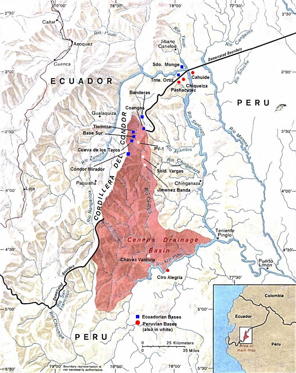
English: Peru-Ecuador (Area of Boundary Dispute). |
| Data | Data desconeguda |
| Font | |
| Autor | The University of Texas at Austin |
| Permís (Com reutilitzar aquest fitxer) |
Stated as public domain. |
Llicència
[modifica]
This work is based on a work in the public domain. It has been digitally enhanced and/or modified. This derivative work has been (or is hereby) released into the public domain by its author, Andres C.. This applies worldwide.
In some countries this may not be legally possible; if so: |
Registre original de càrregues
[modifica]
La pàgina de descripció original era aquí. Els noms d'usuari a continuació es refereixen a en.wikipedia.
- 2010-10-30 14:30 Beao 965×1216× (921862 bytes)
- 2009-10-01 21:16 Andres C. 1000×1292× (876675 bytes) A retouched image of a map located online at the University of Texas Library - PCL Map Collection website. Stated as public domain: http://www.lib.utexas.edu/maps/americas/peru_ecuador_81.jpg "Courtesy of the University of Texas Libraries, The Universit
Historial del fitxer
Cliqueu una data/hora per veure el fitxer tal com era aleshores.
| Data/hora | Miniatura | Dimensions | Usuari/a | Comentari | |
|---|---|---|---|---|---|
| actual | 05:31, 15 set 2012 | | 965 × 1.216 (900 Ko) | OgreBot (discussió | contribucions) | (BOT): Uploading old version of file from en.wikipedia; originally uploaded on 2010-10-30 14:30:35 by Beao |
| 14:47, 10 ago 2010 |  | 1.000 × 1.292 (856 Ko) | File Upload Bot (Magnus Manske) (discussió | contribucions) | {{BotMoveToCommons|en.wikipedia|year={{subst:CURRENTYEAR}}|month={{subst:CURRENTMONTHNAME}}|day={{subst:CURRENTDAY}}}} {{Information |Description={{en|A retouched image of a map located online at the University of Texas Library - PCL Map Collection websi |
No podeu sobreescriure aquest fitxer.
Ús del fitxer
Les 2 pàgines següents utilitzen aquest fitxer:
Ús global del fitxer
Utilització d'aquest fitxer en altres wikis:
- Utilització a az.wikipedia.org
- Utilització a ca.wikipedia.org
- Utilització a de.wikipedia.org
- Utilització a en.wikipedia.org
- Utilització a es.wikipedia.org
- Utilització a et.wikipedia.org
- Utilització a fi.wikipedia.org
- Utilització a he.wikipedia.org
- Utilització a id.wikipedia.org
- Utilització a it.wikipedia.org
- Utilització a ka.wikipedia.org
- Utilització a pt.wikipedia.org
- Utilització a qu.wikipedia.org
- Utilització a ru.wikipedia.org
- Utilització a sv.wikipedia.org
- Utilització a uk.wikipedia.org
- Utilització a www.wikidata.org
- Utilització a zh.wikipedia.org