File:Ceratopsian map.png
跳至導覽
跳至搜尋

預覽大小:800 × 352 像素。 其他解析度:320 × 141 像素 | 640 × 282 像素 | 1,427 × 628 像素。
原始檔案 (1,427 × 628 像素,檔案大小:72 KB,MIME 類型:image/png)
說明
說明
添加單行說明來描述出檔案所代表的內容
File:Ceratopsian map.png requires updating
[編輯]
您好,Ceratopsian map.png
感谢您为共享资源做出贡献。我注意到File:Ceratopsian map.png已经过时。Does not include localitiy of Ferrisaurus 您可以更新它么?再次感谢。 Extrapolaris (對話) 01:17, 11 November 2019 (UTC) Vahe Demirjian
- @Extrapolaris: Done. Thanks for informing me, next time you could leave message on my talk page directly (in traditional Chinese) so I can see it sooner. -- Tiouraren (對話) 10:21, 31 January 2020 (UTC)
摘要
[編輯]
| 描述 |
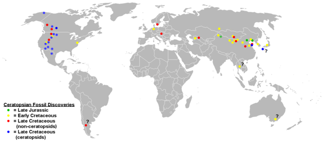
English: Map of ceratopsian fossil localities as of September 2006. I used the blank political map of the world commonly used on Wikipedia ((BlankMap-World.png).
Keep in mind that the land masses would not have been in the same places they are today in the Jurassic and Cretaceous periods. |
| 日期 | 2009年三月17日 (原始上傳日期) |
| 來源 | Transferred from en.wikipedia to Commons by FunkMonk using CommonsHelper. |
| 作者 | 英文維基百科的Sheep81 |
授權條款
[編輯]
| 此作品已由其作者,英文維基百科的Sheep81,釋出至公有領域。此授權條款在全世界均適用。 這可能在某些國家不合法,如果是的話: Sheep81授予任何人有權利使用此作品於任何用途,除受法律約束外,不受任何限制。 |
原始上傳日誌
[編輯]
The original description page was here. All following user names refer to en.wikipedia.
- 2009-03-17 18:48 Dinoguy2 1427×628× (47473 bytes) ''Turanoceratops'' as a ceratopsid, not non-ceratopsid (red dot -> blue dot).
- 2006-09-20 06:18 Sheep81 1427×628× (45407 bytes)
- 2006-09-20 04:44 Sheep81 1427×628× (45348 bytes) Map of ceratopsian fossil localities as of September 2006. I used the blank political map of the world commonly used on Wikipedia ((BlankMap-World.png). Keep in mind that the land masses would not have been in the same places they are today in the Jurass
檔案歷史
點選日期/時間以檢視該時間的檔案版本。
| 日期/時間 | 縮圖 | 尺寸 | 用戶 | 備註 | |
|---|---|---|---|---|---|
| 目前 | 2020年1月31日 (五) 10:11 | | 1,427 × 628(72 KB) | Tiouraren(對話 | 貢獻) | Added the locality of Ferrisaurus |
| 2019年7月31日 (三) 06:07 |  | 1,427 × 628(72 KB) | Tiouraren(對話 | 貢獻) | fixing political border | |
| 2019年7月17日 (三) 14:51 |  | 1,427 × 628(71 KB) | Tiouraren(對話 | 貢獻) | Records from Sweden (Lindgren et al., 2007) and Japan (Manabe et al., 2016) added | |
| 2019年7月14日 (日) 07:38 |  | 1,427 × 628(70 KB) | Tiouraren(對話 | 貢獻) | Add locality of 50+ basal ceratopsian fossils and Crittendenceratops. | |
| 2019年7月14日 (日) 06:18 |  | 1,427 × 628(70 KB) | Tiouraren(對話 | 貢獻) | Turanocertops update | |
| 2018年7月4日 (三) 06:53 |  | 1,427 × 628(61 KB) | Tiouraren(對話 | 貢獻) | Add ''Sinoceratops'', ''Koreaceratops'', ''Yehuecauhceratops'', and ''Machairoceratops'' | |
| 2009年3月26日 (四) 21:46 |  | 1,427 × 628(46 KB) | File Upload Bot (Magnus Manske)(對話 | 貢獻) | {{BotMoveToCommons|en.wikipedia|year={{subst:CURRENTYEAR}}|month={{subst:CURRENTMONTHNAME}}|day={{subst:CURRENTDAY}}}} {{Information |Description={{en|Map of ceratopsian fossil localities as of September 2006. I used the blank political map of the world |
無法覆蓋此檔案。
檔案用途
沒有使用此檔案的頁面。
全域檔案使用狀況
以下其他 wiki 使用了這個檔案:
- en.wikipedia.org 的使用狀況
- es.wikipedia.org 的使用狀況
- hr.wikipedia.org 的使用狀況
- hu.wikipedia.org 的使用狀況
- ko.wikipedia.org 的使用狀況
- ml.wikipedia.org 的使用狀況
- pl.wikipedia.org 的使用狀況
- sh.wikipedia.org 的使用狀況
- tr.wikipedia.org 的使用狀況
- uk.wikipedia.org 的使用狀況
- zh.wikipedia.org 的使用狀況