File:Chariot spread.png
跳至導覽
跳至搜尋
無更高解析度可提供。
Chariot_spread.png (400 × 231 像素,檔案大小:154 KB,MIME 類型:image/png)
說明
說明
添加單行說明來描述出檔案所代表的內容
| 描述 |
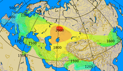
Historical spread of the chariot. This map combines various classes of information, historical and archaeological. The 'isochrones' as given should not be considered more than rough approximations, give or take a century.
|
||||||||
| 日期 | |||||||||
| 來源 | 自己的作品 by by en:User:Dbachmann | ||||||||
| 作者 | by en:User:Dbachmann | ||||||||
| 授權許可 (重用此檔案) |
|
||||||||
| 其他版本 |
|


檔案歷史
點選日期/時間以檢視該時間的檔案版本。
| 日期/時間 | 縮圖 | 尺寸 | 使用者 | 備註 | |
|---|---|---|---|---|---|
| 目前 | 2021年9月27日 (一) 04:00 | | 400 × 231(154 KB) | GPinkerton(留言 | 貢獻) | Reverted to version as of 14:14, 17 August 2005 (UTC) COM:CROP |
| 2021年5月2日 (日) 19:28 |  | 400 × 231(161 KB) | Claude Zygiel(留言 | 貢獻) | North Africa too (Raymond Vaufrey, Préhistoire de l'Afrique, tome II, Service des Publications de l'Université de Tunis, 1969) | |
| 2005年8月17日 (三) 14:14 |  | 400 × 231(154 KB) | Dbachmann(留言 | 貢獻) | correction, labels | |
| 2005年8月17日 (三) 07:14 |  | 350 × 202(119 KB) | Dbachmann(留言 | 貢獻) | by en:User:Dbachmann {{GFDL}} |
無法覆蓋此檔案。
檔案用途
下列6個頁面有用到此檔案:
全域檔案使用狀況
以下其他 wiki 使用了這個檔案:
- az.wikipedia.org 的使用狀況
- ba.wikipedia.org 的使用狀況
- bn.wikipedia.org 的使用狀況
- ca.wikipedia.org 的使用狀況
- cs.wikipedia.org 的使用狀況
- da.wikipedia.org 的使用狀況
- de.wikipedia.org 的使用狀況
- en.wikipedia.org 的使用狀況
- es.wikipedia.org 的使用狀況
- eu.wikipedia.org 的使用狀況
- fa.wikipedia.org 的使用狀況
- fi.wikipedia.org 的使用狀況
- fi.wikibooks.org 的使用狀況
- fr.wikipedia.org 的使用狀況
- hak.wikipedia.org 的使用狀況
- he.wikipedia.org 的使用狀況
- hu.wikipedia.org 的使用狀況
- hy.wikipedia.org 的使用狀況
檢視此檔案的更多全域使用狀況。
詮釋資料
分類:
- Ancient four-wheeled chariots
- War chariots
- Maps of the Sintashta culture
- Archaeological maps
- Maps showing 2nd-millennium BC history
- Maps showing 1st-millennium BC history
- Maps showing 20th-century BC history
- Maps showing 19th-century BC history
- Maps showing 18th-century BC history
- Maps showing 17th-century BC history
- Maps showing 16th-century BC history
- 12th century BC
- 10th century BC
- 6th century BC
- 5th century BC
- Maps of the Bronze Age in China
- Isochrone maps
- Transport statistics