File:China.A2004040.0245.250m.jpg

原始檔案 (5,600 × 7,200 像素,檔案大小:5.4 MB,MIME 類型:image/jpeg)
說明
說明
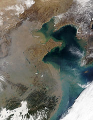
Haze over Eastern China 華北/華東的空氣污染
Credit: Jacques Descloitres, MODIS Rapid Response Team, NASA/GSFC
Across eastern China, the increased use of coal and wood for heating in the winter often leads to widespread haze, such as that seen in this Moderate Resolution Imaging Spectroradiometer (MODIS, [1]) image from the Terra satellite [2] on February 9, 2004. The topography contributes to the effect, as this region is very bowl-like and ringed by mountainous terrain to the west, which prevents the pollution from dispersing.
照片來源:美國國家航空暨太空總署 Jacques Descloitres
在整個華東地區,因冬季取暖而燃燒的煤炭和木材越來越多,經常引起廣泛分布的霧霾,譬如這張2004年2月9日從Terra衛星拍攝的照片所示。地形也是該現象的成因之一,因為這個地區地勢較低,西面又環繞了山地,從而阻止了污染的疏散。
參見:中國的空氣污染
| 本作品由NASA創作,屬於公有領域。根據NASA的版權政策:“NASA的創作除非另有聲明否則不受版權保護。”(參見:Template:PD-USGov/zh,NASA版權政策或JPL圖像使用政策) | ||
 |
警告:
|
檔案歷史
點選日期/時間以檢視該時間的檔案版本。
| 日期/時間 | 縮圖 | 尺寸 | 用戶 | 備註 | |
|---|---|---|---|---|---|
| 目前 | 2005年3月20日 (日) 01:08 | | 5,600 × 7,200(5.4 MB) | R.O.C(對話 | 貢獻) | Haze over Eastern China 華北/華東的空氣污染 |
無法覆蓋此檔案。
檔案用途
下列頁面有用到此檔案:
全域檔案使用狀況
以下其他 wiki 使用了這個檔案:
- de.wikipedia.org 的使用狀況
- he.wikiquote.org 的使用狀況
- id.wikipedia.org 的使用狀況
- it.wikipedia.org 的使用狀況
- ms.wikipedia.org 的使用狀況
- vi.wikipedia.org 的使用狀況
- zh.wikipedia.org 的使用狀況