File:China administrative.png

Πρωτότυπο αρχείο (857 × 699 εικονοστοιχεία, μέγεθος αρχείου: 95 KB, τύπος MIME: image/png)
Λεζάντες
Λεζάντες
NOTE by original author
This map is no longer being updated. The newest version is in GIF format and is located at:

|
This map has been uploaded by Electionworld from en.wikipedia.org to enable the |
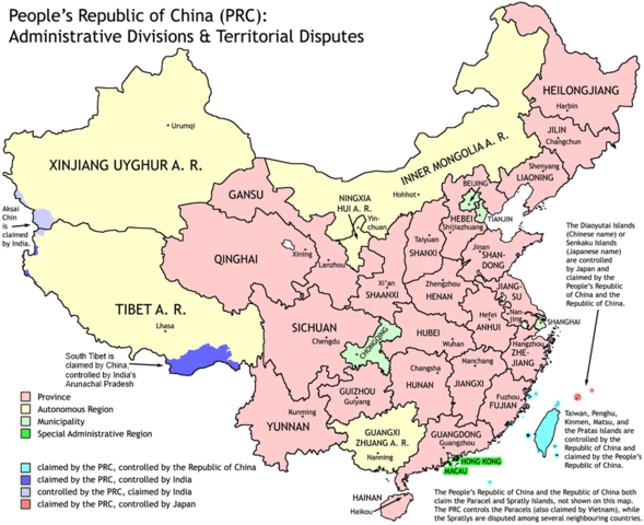
Administrative divisions of China. Made by Ran.
Features:
- Latest borders as of 2004. Qinghai-Gansu border readjustments are reflected; Sino-Russian agreement on the Amur-Ussuri delta is also (approximately) reflected.
- Disputed areas are given as neutral a treatment as possible.
The map was made based on a large-scale map of China made by woodhome and hunry of the XZQH forums.
Looking for translators!: If you want to translate the map into another language, here's a blank map that you can work with:
Alternatively, you can message me with the translated texts, and I will incorporate your translations for you and credit you for your work. (You don't have to translate the place names; I'll attempt to get them, as far as possible, from the Wikipedia in that language.) Same goes for any additions or corrections you'd like to make.
Translations have already been done for Spanish, German, Chinese (Simplified/Traditional), Japanese, French, Russian, Macedonian, Vietnamese, and Hebrew.
See also: en:Wikipedia:WikiProject Chinese provinces/Locator maps

|
Παραχωρείται η άδεια προς αντιγραφή, διανομή και/ή τροποποίηση αυτού του εγγράφου υπό τους όρους της Άδειας Ελεύθερης Τεκμηρίωσης GNU, Έκδοση 1.2 ή οποιασδήποτε νεότερης έκδοσης δημοσιευμένης από το Ίδρυμα Ελεύθερου Λογισμικού· χωρίς Απαράλαχτους Τομείς, χωρίς Κείμενα Εξωφύλλου, και χωρίς Κείμενα Οπισθοφύλλου. Αντίγραφο της άδειας περιλαμβάνεται στην σελίδα με τίτλο GNU Free Documentation License. |
| Το αρχείο διανέμεται υπό την άδεια Creative Commons Αναφορά προέλευσης-Παρόμοια διανομή 3.0 Μη εισαγόμενη | ||
| ||
| Αυτή η ετικέτα άδειας χρήσης προστέθηκε στο αρχείο ως μέρους της αναθεώρησης της άδειας GFDL . |
Ιστορικό αρχείου
Πατήστε σε μια ημερομηνία/ώρα για να δείτε το αρχείο όπως εμφανιζόταν εκείνη την χρονική στιγμή.
| Ημερομηνία/Ώρα | Μικρογραφία | Διαστάσεις | Χρήστης | Σχόλιο | |
|---|---|---|---|---|---|
| τρέχον | 19:43, 1 Οκτωβρίου 2011 | | 857 × 699 (95 KB) | Quigley (συζήτηση | Συνεισφορά) | Southwest disputed area has its own name |
| 20:13, 26 Αυγούστου 2007 |  | 857 × 699 (83 KB) | Ran (συζήτηση | Συνεισφορά) | {{Information |Description= |Source= |Date= |Author= |Permission= |other_versions= }} | |
| 13:52, 16 Δεκεμβρίου 2006 |  | 857 × 699 (83 KB) | Electionworld (συζήτηση | Συνεισφορά) | {{ew|en|Ran}} Administrative divisions of China. Made by Ranr. Features: * Latest borders as of 2004. {{link|Qinghai}}-{{link|Gansu}} border readjustments are reflected; Sino-Russian agreement on the Amur-Ussuri delta is also (approxim |
Δεν μπορείτε να αντικαταστήσετε αυτό το αρχείο.
Χρήση αρχείου
Οι ακόλουθες 9 σελίδες χρησιμοποιούν προς αυτό το αρχείο:
- User talk:Ubold
- File:China administrative zh-hans.svg
- File:China on the globe (all claims hatched) (Asia centered) (alternative).svg
- File:Kitai delenie.png
- File:RP Chine administrative.svg
- File:RP Chine administrative ru.svg
- File:RP Chine administrative uk.svg
- File:Volksrepublik China administrative Gliederung.svg
- Template:Other versions/China administrative
_(Asia_centered)_(alternative).svg)
Καθολική χρήση αρχείου
Τα ακόλουθα άλλα wiki χρησιμοποιούν αυτό το αρχείο:
- Χρήση σε avk.wikipedia.org
- Χρήση σε bg.wikipedia.org
- Χρήση σε blk.wikipedia.org
- Χρήση σε bs.wikipedia.org
- Χρήση σε ca.wikipedia.org
- Χρήση σε cs.wikipedia.org
- Χρήση σε cu.wikipedia.org
- Χρήση σε el.wikipedia.org
- Χρήση σε en.wikipedia.org
- China
- User talk:Yug/Archive01
- File talk:India-locator-map-blank.svg
- User:Ahmadiskandarshah
- User:Palaeovia/sinology
- User:Jonny-mt/Gallery of current first-level administrative country subdivisions maps
- Template:PRC provinces big imagemap
- Outline of China
- Talk:Renminbi/Archive 1
- Talk:Chinese civilization/Archive 26
- User:Riley.W.Uhr/sandbox
- User:Falcaorib
- User:Centralismo
- User talk:FuzionEXA
- User:Sanskar shingare/sandbox
- Χρήση σε en.wikibooks.org
- Χρήση σε en.wikinews.org
- Χρήση σε eu.wikipedia.org
- Χρήση σε fa.wikipedia.org
- Χρήση σε hr.wikipedia.org
- Χρήση σε hy.wikipedia.org
- Χρήση σε incubator.wikimedia.org
- Χρήση σε lt.wikipedia.org
- Χρήση σε mn.wikipedia.org
- Χρήση σε ms.wikipedia.org
- Χρήση σε mwl.wikipedia.org
- Χρήση σε my.wikipedia.org
- Χρήση σε pam.wikipedia.org
- Χρήση σε pt.wikipedia.org
- Χρήση σε qu.wikipedia.org
- Χρήση σε ro.wikipedia.org
- Χρήση σε sd.wikipedia.org
Δείτε περισσότερη καθολική χρήση αυτού του αρχείου.