File:China administrative.png

Исходный файл (857 × 699 пкс, размер файла: 95 КБ, MIME-тип: image/png)
Краткие подписи
Краткие подписи
NOTE by original author
This map is no longer being updated. The newest version is in GIF format and is located at:

|
This map has been uploaded by Electionworld from en.wikipedia.org to enable the |
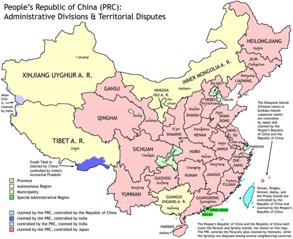
Administrative divisions of China. Made by Ran.
Features:
- Latest borders as of 2004. Qinghai-Gansu border readjustments are reflected; Sino-Russian agreement on the Amur-Ussuri delta is also (approximately) reflected.
- Disputed areas are given as neutral a treatment as possible.
The map was made based on a large-scale map of China made by woodhome and hunry of the XZQH forums.
Looking for translators!: If you want to translate the map into another language, here's a blank map that you can work with:
Alternatively, you can message me with the translated texts, and I will incorporate your translations for you and credit you for your work. (You don't have to translate the place names; I'll attempt to get them, as far as possible, from the Wikipedia in that language.) Same goes for any additions or corrections you'd like to make.
Translations have already been done for Spanish, German, Chinese (Simplified/Traditional), Japanese, French, Russian, Macedonian, Vietnamese, and Hebrew.
See also: en:Wikipedia:WikiProject Chinese provinces/Locator maps

|
Разрешается копировать, распространять и/или изменять этот документ в соответствии с условиями GNU Free Documentation License версии 1.2 или более поздней, опубликованной Фондом свободного программного обеспечения, без неизменяемых разделов, без текстов, помещаемых на первой и последней обложке. Копия лицензии включена в раздел, озаглавленный GNU Free Documentation License. |
| Этот файл доступен по лицензии Creative Commons Attribution-Share Alike 3.0 Unported. | ||
| ||
| Этот признак лицензирования был добавлен к этому файлу как часть обновления лицензии GFDL. |
История файла
Нажмите на дату/время, чтобы увидеть версию файла от того времени.
| Дата/время | Миниатюра | Размеры | Участник | Примечание | |
|---|---|---|---|---|---|
| текущий | 19:43, 1 октября 2011 | | 857 × 699 (95 КБ) | Quigley (обсуждение | вклад) | Southwest disputed area has its own name |
| 20:13, 26 августа 2007 |  | 857 × 699 (83 КБ) | Ran (обсуждение | вклад) | {{Information |Description= |Source= |Date= |Author= |Permission= |other_versions= }} | |
| 13:52, 16 декабря 2006 |  | 857 × 699 (83 КБ) | Electionworld (обсуждение | вклад) | {{ew|en|Ran}} Administrative divisions of China. Made by Ranr. Features: * Latest borders as of 2004. {{link|Qinghai}}-{{link|Gansu}} border readjustments are reflected; Sino-Russian agreement on the Amur-Ussuri delta is also (approxim |
Вы не можете перезаписать этот файл.
Использование файла
Следующие 9 страниц используют этот файл:
- User talk:Ubold
- File:China administrative zh-hans.svg
- File:China on the globe (all claims hatched) (Asia centered) (alternative).svg
- File:Kitai delenie.png
- File:RP Chine administrative.svg
- File:RP Chine administrative ru.svg
- File:RP Chine administrative uk.svg
- File:Volksrepublik China administrative Gliederung.svg
- Template:Other versions/China administrative
_(Asia_centered)_(alternative).svg)
Глобальное использование файла
Данный файл используется в следующих вики:
- Использование в avk.wikipedia.org
- Использование в bg.wikipedia.org
- Использование в blk.wikipedia.org
- Использование в bs.wikipedia.org
- Использование в ca.wikipedia.org
- Использование в cs.wikipedia.org
- Использование в cu.wikipedia.org
- Использование в el.wikipedia.org
- Использование в en.wikipedia.org
- China
- User talk:Yug/Archive01
- File talk:India-locator-map-blank.svg
- User:Ahmadiskandarshah
- User:Palaeovia/sinology
- User:Jonny-mt/Gallery of current first-level administrative country subdivisions maps
- Template:PRC provinces big imagemap
- Outline of China
- Talk:Renminbi/Archive 1
- Talk:Chinese civilization/Archive 26
- User:Riley.W.Uhr/sandbox
- User:Centralismo
- User talk:FuzionEXA
- User:Sanskar shingare/sandbox
- User:Falcaorib/China
- Использование в en.wikibooks.org
- Использование в en.wikinews.org
- Использование в eu.wikipedia.org
- Использование в fa.wikipedia.org
- Использование в hr.wikipedia.org
- Использование в hy.wikipedia.org
- Использование в incubator.wikimedia.org
- Использование в lt.wikipedia.org
- Использование в mn.wikipedia.org
- Использование в ms.wikipedia.org
- Использование в mwl.wikipedia.org
- Использование в my.wikipedia.org
- Использование в pam.wikipedia.org
- Использование в pt.wikipedia.org
- Использование в qu.wikipedia.org
- Использование в rm.wikipedia.org
- Использование в ro.wikipedia.org
Просмотреть глобальное использование этого файла.