File:Cities in China.png
跳至導覽
跳至搜尋
預覽大小:759 × 600 像素。 其他解析度:304 × 240 像素 | 607 × 480 像素 | 972 × 768 像素 | 1,280 × 1,012 像素 | 2,560 × 2,023 像素 | 6,246 × 4,937 像素。
原始檔案 (6,246 × 4,937 像素,檔案大小:895 KB,MIME 類型:image/png)
說明
說明
添加單行說明來描述出檔案所代表的內容

|
該圖像需要長期保持更新。如果有需要請更新該圖像。
|

|
This file may be updated to reflect new information. If you wish to use a specific version of the file without new updates being mirrored, please upload the required version as a separate file. |
摘要[編輯]
| 描述 |
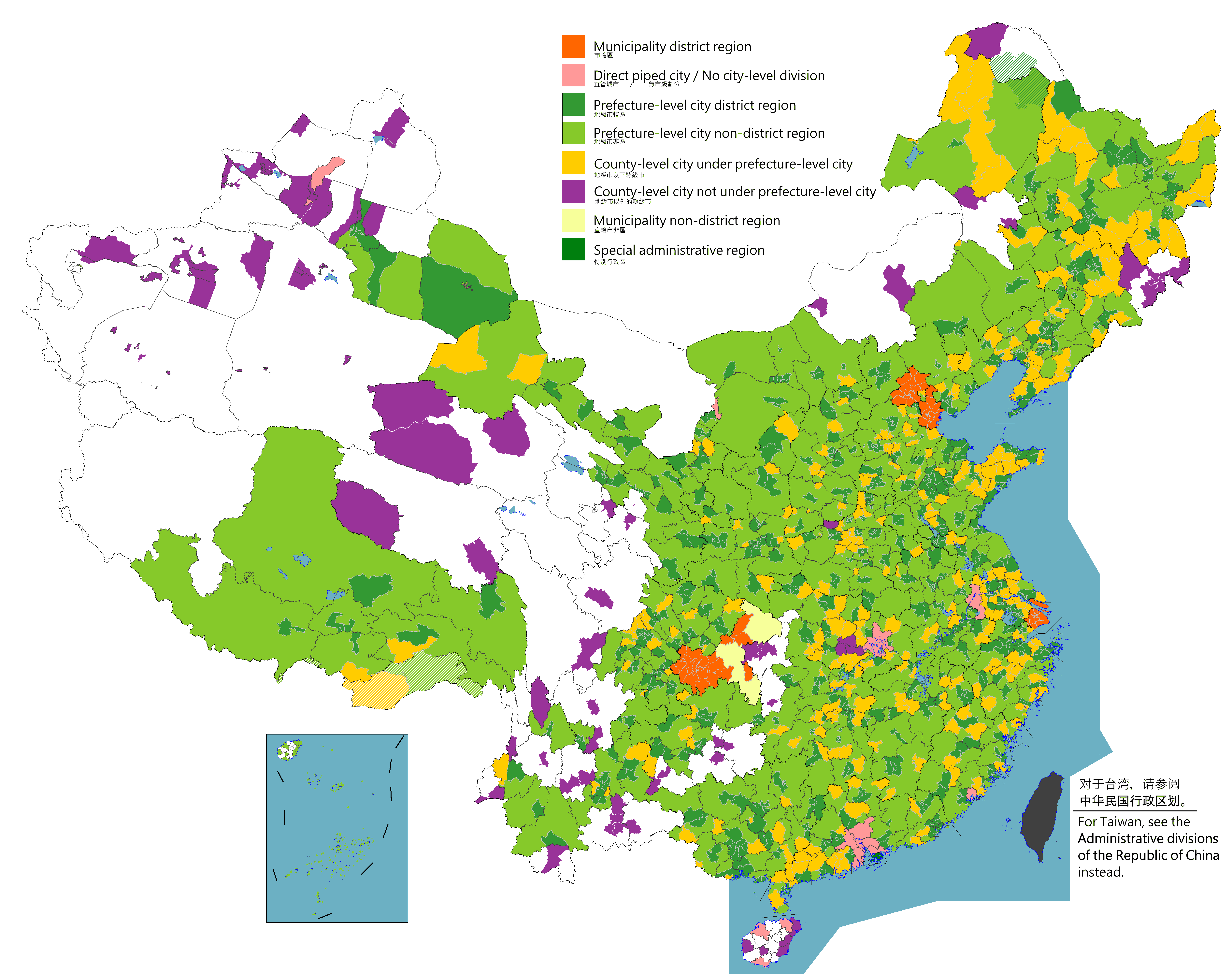
English: Map of China's types of cities.
日本語: 中国の都市の種類の地図。
Русский: Карта типов городов Китая.
Монгол: Хятадын төрлийн хотуудын газрын зураг.
中文(简体):中国城市类型图。(包含未實際控制之疆域)
中文(繁體):中國城市類型圖。 (包含未實際控制之疆域) |
| 日期 |
|
| 來源 |
Legend: Municipality district region
Direct piped city / No city-level division
Prefecture-level city district region
Prefecture-level city non-district region
County-level city under prefecture-level city
County-level city not prefecture-level city
Municipality non-district region
Special administrative region
Source appearances:
[]
|
| 作者 |
|
| 授權許可 (重用此檔案) |
Map of China, types of cities: |
.png)
.png)
授權條款[編輯]
我,本作品的著作權持有者,決定用以下授權條款發佈本作品:
此檔案採用創用CC 姓名標示-相同方式分享 4.0 國際授權條款。
- 您可以自由:
- 分享 – 複製、發佈和傳播本作品
- 重新修改 – 創作演繹作品
- 惟需遵照下列條件:
- 姓名標示 – 您必須指名出正確的製作者,和提供授權條款的連結,以及表示是否有對內容上做出變更。您可以用任何合理的方式來行動,但不得以任何方式表明授權條款是對您許可或是由您所使用。
- 相同方式分享 – 如果您利用本素材進行再混合、轉換或創作,您必須基於如同原先的相同或兼容的條款,來分布您的貢獻成品。

|
本圖片是以PNG、GIF或JPEG格式上傳。然而,其中包含的資料或訊息,應該重新建立成可縮放向量圖形(SVG)檔案,以更有效率或更準確的方式儲存。如有可能,請上傳本圖片的SVG格式版本。在上傳之後,請修改維基各姊妹計畫中所有使用舊版圖片的條目(列在圖像連結章節中),替換為新版圖片,並在舊圖片的描述頁中加入{{Vector version available|新圖片名稱.svg}}模板,同時移除本模板。
|
|
|
本圖片是以PNG、GIF或JPEG格式上傳。然而,其中包含的資料或訊息,應該重新建立成可縮放向量圖形(SVG)檔案,以更有效率或更準確的方式儲存。如有可能,請上傳本圖片的SVG格式版本。在上傳之後,請修改維基各姊妹計畫中所有使用舊版圖片的條目(列在圖像連結章節中),替換為新版圖片,並在舊圖片的描述頁中加入{{Vector version available|新圖片名稱.svg}}模板,同時移除本模板。
|
| 註解 | 該圖片含有註解:在維基媒體共享資源上查看註解 |
檔案歷史
點選日期/時間以檢視該時間的檔案版本。
| 日期/時間 | 縮圖 | 尺寸 | 使用者 | 備註 | |
|---|---|---|---|---|---|
| 目前 | 2023年8月2日 (三) 10:09 | | 6,246 × 4,937(895 KB) | Maanshen(留言 | 貢獻) | |
| 2023年8月2日 (三) 09:59 |  | 6,246 × 4,937(897 KB) | Maanshen(留言 | 貢獻) | ||
| 2023年8月2日 (三) 09:51 |  | 6,246 × 4,937(893 KB) | Maanshen(留言 | 貢獻) | ||
| 2023年8月1日 (二) 08:59 |  | 6,246 × 4,937(891 KB) | Maanshen(留言 | 貢獻) | ||
| 2022年8月2日 (二) 23:06 |  | 6,246 × 4,937(901 KB) | Maanshen(留言 | 貢獻) | Update disputed/claimed borders, white with stroke is not claimed and filled in color is claimed | |
| 2022年4月20日 (三) 00:08 |  | 6,246 × 4,937(893 KB) | Maanshen(留言 | 貢獻) | Fix borders between Ili's Kuytun, Huyanghe, and Karamay | |
| 2022年3月31日 (四) 01:45 |  | 6,246 × 4,937(893 KB) | Maanshen(留言 | 貢獻) | Fix some colors | |
| 2022年3月29日 (二) 00:59 |  | 6,246 × 4,937(893 KB) | Maanshen(留言 | 貢獻) | Fix colors in Shanxi with Fenyang and Xiaoyi | |
| 2022年3月17日 (四) 01:00 |  | 6,246 × 4,937(893 KB) | Maanshen(留言 | 貢獻) | Fix Dongtai as a county-level city | |
| 2022年3月1日 (二) 03:51 |  | 6,246 × 4,937(893 KB) | Maanshen(留言 | 貢獻) | Update Shanghai land reclamation and cpunty border changes as of 2022 |
無法覆蓋此檔案。
檔案用途
沒有使用此檔案的頁面。
全域檔案使用狀況
以下其他 wiki 使用了這個檔案:
- en.wikipedia.org 的使用狀況
- fi.wikipedia.org 的使用狀況
- id.wikipedia.org 的使用狀況
- ilo.wikipedia.org 的使用狀況
- ko.wikipedia.org 的使用狀況
- ku.wikipedia.org 的使用狀況
- mk.wikipedia.org 的使用狀況
- mn.wikipedia.org 的使用狀況
- ne.wikipedia.org 的使用狀況
- th.wikipedia.org 的使用狀況
- tr.wikipedia.org 的使用狀況
- uz.wikipedia.org 的使用狀況
- zh.wikipedia.org 的使用狀況