File:Clay City National Bank Building.jpg
Salta a la navegació
Salta a la cerca

Mida d'aquesta previsualització: 800 × 532 píxels. Altres resolucions: 320 × 213 píxels | 640 × 426 píxels | 1.024 × 681 píxels | 1.280 × 851 píxels | 2.560 × 1.702 píxels | 6.016 × 4.000 píxels.
Fitxer original (6.016 × 4.000 píxels, mida del fitxer: 7,17 Mo, tipus MIME: image/jpeg)
Llegendes
Llegendes
Afegeix una explicació d'una línia del que representa aquest fitxer
|
This is an image of a place or building that is listed on the National Register of Historic Places in the United States of America. Its reference number is 76000940. |
| Posició de la càmera | | Aquesta i altres imatges properes a: OpenStreetMap |
|---|
| Descripció |
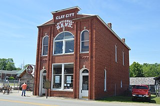
English: Front and northwestern side of the Clay City National Bank Building, located on the southwestern side of Main Street (Kentucky Routes 11/15) in central Clay City, Kentucky, United States. Built in 1890 and now a museum, it is listed on the National Register of Historic Places. |
||
| Data | Taken on 14 de juny de 2014 | ||
| Font | Treball propi | ||
| Autor | Nyttend | ||
| Permís (Com reutilitzar aquest fitxer) |
|
Historial del fitxer
Cliqueu una data/hora per veure el fitxer tal com era aleshores.
| Data/hora | Miniatura | Dimensions | Usuari/a | Comentari | |
|---|---|---|---|---|---|
| actual | 05:22, 23 juny 2014 | | 6.016 × 4.000 (7,17 Mo) | Nyttend (discussió | contribucions) | {{NRHP|76000940}} {{Location|37|51|38|N|83|55|16|W}} {{Information |Description={{en|Front and northwestern side of the {{w|Clay City National Bank Building}}, located on the southwestern side of Main Street (Kentucky Routes {{w|Kentucky Route 11|11}}/... |
No podeu sobreescriure aquest fitxer.
Ús del fitxer
La pàgina següent utilitza aquest fitxer:
Ús global del fitxer
Utilització d'aquest fitxer en altres wikis:
- Utilització a ar.wikipedia.org
- Utilització a arz.wikipedia.org
- Utilització a azb.wikipedia.org
- Utilització a ca.wikipedia.org
- Utilització a ceb.wikipedia.org
- Utilització a ce.wikipedia.org
- Utilització a en.wikipedia.org
- Utilització a es.wikipedia.org
- Utilització a eu.wikipedia.org
- Utilització a fr.wikipedia.org
- Utilització a ht.wikipedia.org
- Utilització a it.wikipedia.org
- Utilització a ky.wikipedia.org
- Utilització a lld.wikipedia.org
- Utilització a pl.wikipedia.org
- Utilització a pt.wikipedia.org
- Utilització a sr.wikipedia.org
- Utilització a sv.wikipedia.org
- Utilització a tt.wikipedia.org
- Utilització a uk.wikipedia.org
- Utilització a uz.wikipedia.org
- Utilització a www.wikidata.org
- Utilització a zh-min-nan.wikipedia.org