File:Cleveland Ohio aerial view.jpg
ナビゲーションに移動
検索に移動

このプレビューのサイズ: 800 × 534 ピクセル。 その他の解像度: 320 × 214 ピクセル | 640 × 427 ピクセル | 1,024 × 683 ピクセル | 1,500 × 1,001 ピクセル。
元のファイル (1,500 × 1,001 ピクセル、ファイルサイズ: 680キロバイト、MIME タイプ: image/jpeg)
キャプション
キャプション
このファイルの内容を1行で記述してください
概要[編集]
| 解説 |
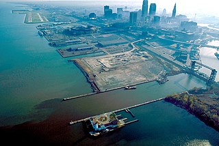
English: Aerial view of Cleveland, Ohio, USA, on the shores of Lake Erie. The mouth of the Cuyahoga River is visible in the foreground and Cleveland's Burke-Lakefront Airport is visible in the top left of the picture. View is to the northeast |
| 日付 | |
| 原典 |
U.S. Army Corps of Engineers Digital Visual Library Image page Image description page Digital Visual Library home page |
| 作者 | Ken Winters, U.S. Army Corps of Engineers |
| 場所 | Cleveland, Ohio, USA |
| カメラの位置 | | 以下のサービスでこの位置を確認する: オープンストリートマップ |
|---|
概要[編集]
This image or file is a work of a U.S. Army Corps of Engineers soldier or employee, taken or made as part of that person's official duties. As a work of the U.S. federal government, the image is in the public domain.
|
ファイルの履歴
過去の版のファイルを表示するには、その版の日時をクリックしてください。
| 日付と時刻 | サムネイル | 寸法 | 利用者 | コメント | |
|---|---|---|---|---|---|
| 現在の版 | 2007年3月25日 (日) 01:58 | | 1,500 × 1,001 (680キロバイト) | DanMS (トーク | 投稿記録) | {{Information | Description = {{en|Aerial view of Cleveland, Ohio, USA, on the shores of Lake Erie. The mouth of the Cuyahoga River is visible in the foreground and Cleveland Airport is visible in the top left of the picture. View is to the northeast}} |
このファイルは上書きできません。
ファイルの使用状況
このファイルを使用しているページはありません。
グローバルなファイル使用状況
以下に挙げる他のウィキがこの画像を使っています:
- de.wikivoyage.org での使用状況
- en.wikipedia.org での使用状況
- eu.wikipedia.org での使用状況
- fr.wikipedia.org での使用状況
- it.wikipedia.org での使用状況
- ja.wikipedia.org での使用状況