File:Climatic zones and antipodes.png
Climatic_zones_and_antipodes.png (180 × 180 píxeles; tamaño de archivo: 31 kB; tipo MIME: image/png)
Leyendas
Leyendas
Resumen
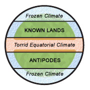
[editar]Diagram illustrating the classical climatic zones. The torrid (and "unhabitable") climatic zone of the equator is in red, the cold (and "unhabitable") climatic zones at the poles are in white/blue.
"Dating back to classical times, most people thought of the world as divided into zones of climate: a frozen climate at the poles, a torrid climate at the equator, and a blissfully mild (and therefore habitable) climate in between. They logically connected the temperature difference of these zones with proximity to the sun, and to a large extent they were right. Where they were wrong, however, was in their belief that the cold and torrid zones were impassable." [1] archive copy at the Wayback Machine
This image was made by Leinad-Z. Based on Image:Mappaemundi vertical.gif by John Hamer and inspired by images from Macrobius' Commentarii in Somnium Scipionis. More specifically, the picture is related with the two diagrams below.
-
 The five climatic zones of the earth.
 -
 Figure of the Earth from Macrobius.


Licencia
[editar]
- Eres libre:
- de compartir – de copiar, distribuir y transmitir el trabajo
- de remezclar – de adaptar el trabajo
- Bajo las siguientes condiciones:
- atribución – Debes otorgar el crédito correspondiente, proporcionar un enlace a la licencia e indicar si realizaste algún cambio. Puedes hacerlo de cualquier manera razonable pero no de manera que sugiera que el licenciante te respalda a ti o al uso que hagas del trabajo.

|
Esta imagen debería volverse a crear como imágenes vectoriales SVG. Esto proporciona muchas ventajas, véase Commons:Media for cleanup (en inglés) para más información. Si ya hay una versión SVG de esta imagen disponible, por favor súbala a Commons. Tras subirla, reemplace esta plantilla con la plantilla
{{vector version available|nuevo nombre de imagen.svg}} en esta imagen. |
Historial del archivo
Haz clic sobre una fecha y hora para ver el archivo tal como apareció en ese momento.
| Fecha y hora | Miniatura | Dimensiones | Usuario | Comentario | |
|---|---|---|---|---|---|
| actual | 21:25 18 ago 2006 | | 180 × 180 (31 kB) | Leinad-Z~commonswiki (discusión | contribs.) | "Texturized" version. |
| 21:23 18 ago 2006 |  | 180 × 180 (12 kB) | Leinad-Z~commonswiki (discusión | contribs.) | New colors and text position. | |
| 19:44 17 ago 2006 |  | 180 × 180 (12 kB) | Leinad-Z~commonswiki (discusión | contribs.) | Made by by Leinad-Z. Based on Image:Mappaemundi vertical.gif by John Hamer. |
No puedes sobrescribir este archivo.
Usos del archivo
La siguiente página usa este archivo:
Uso global del archivo
Las wikis siguientes utilizan este archivo:
- Uso en ar.wikipedia.org
- Uso en en.wikipedia.org
- Uso en es.wikipedia.org
- Uso en hu.wikipedia.org
- Uso en no.wikipedia.org