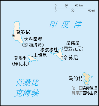
File:Cn-map-zh.png
出自Wikimedia Commons
跳至導覽
跳至搜尋
Cn-map-zh.png (330 × 355 像素,檔案大小:13 KB,MIME 類型:image/png)
檔案資訊
結構化資料
說明
說明
添加單行說明來描述出檔案所代表的內容
摘要[編輯]
| 描述Cn-map-zh.png |
此檔案沒有任何描述,並且可能缺少其他資訊。
請提供此檔案更具意義的描述。 |
| 日期 | (UTC) |
| 來源 |
本檔案衍生自: Cn-map.png:  |
| 作者 |
|
| 這是一張修飾過的圖片,即本圖片是用軟體修改過後的版本,修改的方式或內容有:Translated into Chinese。原版圖片來源:Cn-map.png。修改者:GnolizX。
|
授權條款[編輯]
| Public domainPublic domainfalsefalse |
|
Bahasa Indonesia ∙ čeština ∙ Deutsch ∙ eesti ∙ English ∙ español ∙ Esperanto ∙ français ∙ galego ∙ hrvatski ∙ italiano ∙ Nederlands ∙ norsk nynorsk ∙ polski ∙ português ∙ sicilianu ∙ slovenščina ∙ suomi ∙ Türkçe ∙ Zazaki ∙ беларуская (тарашкевіца) ∙ македонски ∙ русский ∙ српски / srpski ∙ українська ∙ ქართული ∙ বাংলা ∙ தமிழ் ∙ മലയാളം ∙ 한국어 ∙ 日本語 ∙ 中文 ∙ 中文(简体) ∙ 中文(繁體) ∙ العربية ∙ +/− |
 |
原始上傳日誌[編輯]
This image is a derivative work of the following images:
- File:Cn-map.png licensed with PD-USGov-CIA-WF
- 2005-02-28T20:13:36Z Alfio 330x355 (5728 Bytes) CIA map of the Comoros
Uploaded with derivativeFX
檔案歷史
點選日期/時間以檢視該時間的檔案版本。
| 日期/時間 | 縮圖 | 尺寸 | 使用者 | 備註 | |
|---|---|---|---|---|---|
| 目前 | 2020年4月6日 (一) 04:03 |  | 330 × 355(13 KB) | GnolizX(留言 | 貢獻) | == {{int:filedesc}} == {{Information |Description= |Source={{Derived from|Cn-map.png|display=50}} |Date=2020-04-06 04:02 (UTC) |Author=* File:Cn-map.png * derivative work: [[User:{{subst:REVISIONUSER}}|{{subst:REVISIONUSER}}]] |Permission= |other_versions= }} {{RetouchedPicture|Translated into Chinese|editor=GnolizX|orig=Cn-map.png}} == {{int:license-header}} == {{self|PD-USGov-CIA-WF}} == {{Original upload log}} == This image is a derivative work of the following imag... |
無法覆蓋此檔案。
檔案用途
沒有使用此檔案的頁面。
全域檔案使用狀況
詮釋資料
此檔案中包含其他資訊,這些資訊可能是由數位相機或掃描器在建立或數位化過程中所新增的。若檔案自原始狀態已被修改,一些詳細資料可能無法完整反映出已修改的檔案。
| 水平解析度 | 37.8 dpc |
|---|---|
| 垂直解析度 | 37.8 dpc |
