File:Cochise County Incorporated and Unincorporated areas Sierra Vista highlighted.svg
Spring til navigation
Spring til søgning

Size of this PNG preview of this SVG file: 800 × 565 pixels. Andre opløsninger: 320 × 226 pixels | 640 × 452 pixels | 1.024 × 723 pixels | 1.280 × 904 pixels | 2.560 × 1.807 pixels.
Oprindelig fil (SVG fil, basisstørrelse 850 × 600 pixels, filstørrelse: 50 KB)
Captions
Captions
Tilføj en kort forklaring på en enkelt linje om hvad filen viser
Beskrivelse[redigér]
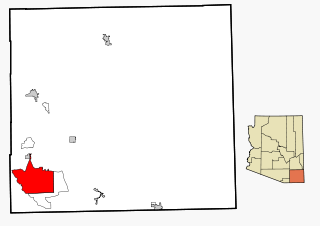
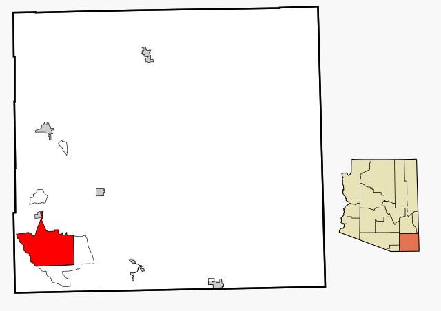
| Beskrivelse | This map shows the incorporated areas and unincorporated areas in Cochise County, Arizona. Sierra Vista is highlighted in red. Incorporated cities are shown in gray and unincorporated communities or CDPs are shown in white. Data for the borders and locations are based on files from the SouthEastern Arizona Governments Organization HPMS Maps and Records and maps from the US Census Bureau TIGER Map Server. I created this map in Inkscape. |
| Dato | |
| Kilde | My own work, based on public domain information |
| Forfatter | Ixnayonthetimmay |
| Tilladelse (Genbrug af denne fil) |
Copyleft-type licensing. See below. |
| Andre versioner | See Category:Maps of Cochise County for other versions of this image. |
Licensering[redigér]
| Jeg, indehaveren af ophavsretten til dette værk, udgiver dette værk som offentlig ejendom. Dette gælder i hele verden. I nogle lande er dette ikke juridisk muligt. I så fald: Jeg giver enhver ret til at anvende dette værk til ethvert formål, uden nogen restriktioner, medmindre sådanne restriktioner er påkrævede ved lov. |
Filhistorik
Klik på en dato/tid for at se filen som den så ud på det tidspunkt.
| Dato/tid | Miniaturebillede | Dimensioner | Bruger | Kommentar | |
|---|---|---|---|---|---|
| nuværende | 27. feb. 2007, 18:18 | | 850 × 600 (50 KB) | Ixnayonthetimmay (diskussion | bidrag) | {{Information |Description=This map shows the incorporated areas and unincorporated areas in Cochise County, Arizona. [[:en:Sierra Vista, Arizona|Sierra Vista |
Du kan ikke overskrive denne fil.
Filanvendelse
Den følgende side bruger denne fil:
Global filanvendelse
Følgende andre wikier anvender denne fil:
- Anvendelser på ar.wikipedia.org
- Anvendelser på arz.wikipedia.org
- Anvendelser på ca.wikipedia.org
- Anvendelser på ceb.wikipedia.org
- Anvendelser på cy.wikipedia.org
- Anvendelser på da.wikipedia.org
- Anvendelser på de.wikipedia.org
- Anvendelser på eu.wikipedia.org
- Anvendelser på fa.wikipedia.org
- Anvendelser på fr.wikipedia.org
- Anvendelser på ga.wikipedia.org
- Anvendelser på ht.wikipedia.org
- Anvendelser på hu.wikipedia.org
- Anvendelser på ja.wikipedia.org
- Anvendelser på mrj.wikipedia.org
- Anvendelser på pt.wikipedia.org
- Anvendelser på sr.wikipedia.org
- Anvendelser på tt.wikipedia.org
- Anvendelser på ur.wikipedia.org
- Anvendelser på vo.wikipedia.org
- Anvendelser på www.wikidata.org
- Anvendelser på zh-min-nan.wikipedia.org