File:Cold War-1970.png
跳至導覽
跳至搜尋
預覽大小:800 × 370 像素。 其他解析度:320 × 148 像素 | 640 × 296 像素 | 1,357 × 628 像素。
原始檔案 (1,357 × 628 像素,檔案大小:57 KB,MIME 類型:image/png)
說明
說明
添加單行說明來描述出檔案所代表的內容
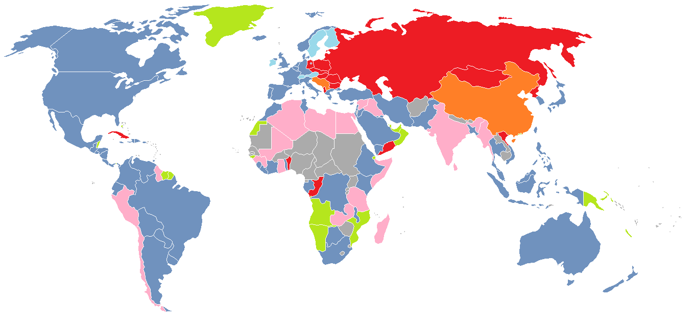
The main areas of Cold War 1962 - 1979
摘要
[編輯]
| 描述 |
English: A color-coded map of the world in 1970, showing various groups of countries depending on their position in the Cold War
Français : Carte du monde montrant par un code couleur les alliances en 1970 pendant la Guerre Froide
Русский: Политическая карта мира на 1970 год, показывающая отношение стран к противникам Холодной войны
Latviešu: Pasaules politiskā karte uz 1970. gadu, kas parāda valstu nostāju Aukstā kara laikā
|
| 日期 | |
| 來源 | 自己的作品 |
| 作者 | J_intela (talk) (Uploads) |
授權條款
[編輯]
| 此作品已由其作者,英文維基百科的J intela,釋出至公有領域。此授權條款在全世界均適用。 這可能在某些國家不合法,如果是的話: J intela授予任何人有權利使用此作品於任何用途,除受法律約束外,不受任何限制。 |
原始上傳日誌
[編輯]
The original description page was here. All following user names refer to en.wikipedia.
| 日期/時間 | 尺寸 | 用戶 | 備註 |
|---|---|---|---|
| 2012-07-10 17:09 | 1357×628× (58145 bytes) | J intela | Fixed Guyana and Jamaca |
| 2012-07-09 19:26 | 1357×628× (58146 bytes) | J intela | Forgot Malawi |
| 2012-07-09 19:23 | 1357×628× (58150 bytes) | J intela | Forgot Farro Islands |
| 2012-07-09 19:15 | 1357×628× (58174 bytes) | J intela | A thorough map of the cold war in the world in 1970 |
檔案歷史
點選日期/時間以檢視該時間的檔案版本。
| 日期/時間 | 縮圖 | 尺寸 | 用戶 | 備註 | |
|---|---|---|---|---|---|
| 目前 | 2015年2月23日 (一) 01:15 | | 1,357 × 628(57 KB) | BD2412(對話 | 貢獻) | Transferred from en.wikipedia |
無法覆蓋此檔案。
檔案用途
沒有使用此檔案的頁面。
全域檔案使用狀況
以下其他 wiki 使用了這個檔案:
- en.wikipedia.org 的使用狀況
- fr.wikipedia.org 的使用狀況
- hu.wikipedia.org 的使用狀況
- id.wikipedia.org 的使用狀況
- ru.wikipedia.org 的使用狀況
- uk.wikipedia.org 的使用狀況
- zh.wikipedia.org 的使用狀況