File:Cold War border changes.png
Salta a la navegació
Salta a la cerca
No hi ha cap versió amb una resolució més gran.
Cold_War_border_changes.png (599 × 436 píxels, mida del fitxer: 25 Ko, tipus MIME: image/png)
Llegendes
Llegendes
Afegeix una explicació d'una línia del que representa aquest fitxer
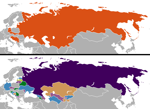
Internationally recognized borders and countries after the Cold War.
Resum[modifica]
| Descripció |
English: Changes in internationally recognized boundaries of countries after the end of the Cold War. Orange in the "before" map represents the territories as of 1991 which were affected. |
| Data | |
| Font | Treball propi |
| Autor | Aivazovsky (talk) (Uploads) |
Llicència[modifica]
| S'ha alliberat aquesta obra al domini públic pel seu autor Aivazovsky de la Viquipèdia en anglès. Això s'aplica a tot el món. En alguns països això pot no ser legalment possible, en tal cas: Aivazovsky concedeix a tothom el dret d'usar aquesta obra per a qualsevol propòsit, sense cap condició llevat d'aquelles requerides per la llei. |
Colored by User:Aivazovsky from public domain Wikimedia Commons source.
Registre original de càrregues[modifica]
La pàgina de descripció original era aquí. Els noms d'usuari a continuació es refereixen a en.wikipedia.
| Data/hora | Dimensions | Usuari/a | Comentari |
|---|---|---|---|
| 2009-12-11 10:57 | 599×436× (15723 bytes) | Ithanyx | Switched to most up-to-date template version. |
| 2008-07-19 07:01 | 599×436× (15610 bytes) | Hoshie | added the last change of the cold war: Kosovo |
| 2007-09-24 04:24 | 599×436× (20607 bytes) | Hoshie | fixed shading on two islands west of the Estonian SSR |
| 2007-02-27 02:21 | 599×436× (15749 bytes) | Aivazovsky | |
| 2006-10-10 06:35 | 599×436× (17502 bytes) | Hoshie | I have updated the map to include Montenegro, the last nation formed out of the cold war. |
| 2006-04-13 01:44 | 602×373× (14138 bytes) | Aivazovsky |
Historial del fitxer
Cliqueu una data/hora per veure el fitxer tal com era aleshores.
| Data/hora | Miniatura | Dimensions | Usuari/a | Comentari | |
|---|---|---|---|---|---|
| actual | 01:08, 26 nov 2023 | | 599 × 436 (25 Ko) | Ljutikecap2021 (discussió | contribucions) | Reverted to version as of 23:24, 21 June 2023 (UTC) |
| 20:52, 18 set 2023 |  | 599 × 436 (18 Ko) | GPinkerton (discussió | contribucions) | Reverted to version as of 12:49, 19 March 2023 (UTC) Most of UN member states recognize Kosovo. Reverting pro-Serbian irredentist claims. | |
| 23:24, 21 juny 2023 |  | 599 × 436 (25 Ko) | Ljutikecap2021 (discussió | contribucions) | Reverted to version as of 21:56, 18 March 2023 (UTC) Most countries is nothing, if the UN doesn't recognize Kosovo as independent then it isn't. | |
| 12:49, 19 març 2023 |  | 599 × 436 (18 Ko) | GPinkerton (discussió | contribucions) | Reverted to version as of 15:41, 11 January 2023 (UTC) Kosovo is recognized as independent by most countries | |
| 21:56, 18 març 2023 |  | 599 × 436 (25 Ko) | Ljutikecap2021 (discussió | contribucions) | If we are going by international recognititon, then Kosovo is Serbia. | |
| 15:41, 11 gen 2023 |  | 599 × 436 (18 Ko) | GPinkerton (discussió | contribucions) | Reverted to version as of 20:15, 17 October 2022 (UTC) The map shows internationally recognized borders not Russian Lebensraum | |
| 14:52, 11 gen 2023 |  | 599 × 436 (25 Ko) | Ljutikecap2021 (discussió | contribucions) | If Kosovo is included, why shouldn't the disputed Russian territories in Eastern Ukraine, Transnistria and Artsakh be included? | |
| 02:59, 26 des 2022 |  | 599 × 436 (18 Ko) | GPinkerton (discussió | contribucions) | Reverted to version as of 20:15, 17 October 2022 (UTC) Undiscussed and unhelpful pro-Russian changes | |
| 21:58, 11 des 2022 |  | 599 × 436 (25 Ko) | Ljutikecap2021 (discussió | contribucions) | New Russian territories, Artsakh and Transnistria added. | |
| 21:08, 4 des 2022 |  | 599 × 436 (21 Ko) | Savasampion (discussió | contribucions) | . |
No podeu sobreescriure aquest fitxer.
Ús del fitxer
No hi ha pàgines que utilitzin aquest fitxer.
Ús global del fitxer
Utilització d'aquest fitxer en altres wikis:
- Utilització a af.wikipedia.org
- Utilització a arz.wikipedia.org
- Utilització a bn.wikipedia.org
- Utilització a ca.wikipedia.org
- Utilització a ckb.wikipedia.org
- Utilització a cs.wikipedia.org
- Utilització a cy.wikipedia.org
- Utilització a el.wikipedia.org
- Utilització a en.wikipedia.org
- History of Europe
- Irredentism
- Mikhail Gorbachev
- Nation state
- Nationalism
- Self-determination
- Eastern Bloc
- Secession
- Balkanization
- Cold War
- Revanchism
- Territorial evolution of Russia
- Revolutions of 1989
- List of national border changes (1914–present)
- Post–Cold War era
- Dissolution of the Soviet Union
- User:Falcaorib/World Alliances
- Utilització a en.wikibooks.org
- Utilització a es.wikipedia.org
- Utilització a hu.wikipedia.org
- Utilització a hy.wikipedia.org
- Utilització a id.wikipedia.org
- Utilització a ja.wikipedia.org
- Utilització a kk.wikipedia.org
- Utilització a ko.wikipedia.org
- Utilització a mk.wikipedia.org
- Utilització a ml.wikipedia.org
- Utilització a pa.wikipedia.org
- Utilització a pnb.wikipedia.org
- Utilització a pt.wikipedia.org
- Utilització a rm.wikipedia.org
- Utilització a sl.wikipedia.org
- Utilització a sr.wikipedia.org
- Utilització a ta.wikipedia.org
- Utilització a ur.wikipedia.org
Vegeu més usos globals d'aquest fitxer.