File:Colonisation 1812.png
跳去導覽
跳去搵嘢

預覽大細:800 × 370 像素。 第啲解像度:320 × 148 像素 | 640 × 296 像素 | 1,357 × 628 像素。
原本檔案 (1,357 × 628 像素,檔案大細:16 KB ,MIME類型:image/png)
Captions
Captions
Add a one-line explanation of what this file represents
摘要
[編輯]| 描述 |
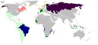
English: Colonial empires in 1812 Français : Empires coloniaux en 1812 Español: Imperios coloniales en 1812 Português: Impérios Coloniais em 1812
Britain
French Empire
French satellite states
Russia
Denmark
Portugal
others
|
||||||||||||||||
| 日期 | |||||||||||||||||
| 來源 | 自己作品 | ||||||||||||||||
| 作者 | Hruska | ||||||||||||||||
| 許可 (重用呢個檔案) |
|
||||||||||||||||
| Other versions |
|
||||||||||||||||


.jpg)
._LOC_2001620596.jpg)
協議
[編輯]
| I, the copyright holder of this work, release this work into the public domain. This applies worldwide. In some countries this may not be legally possible; if so: I grant anyone the right to use this work for any purpose, without any conditions, unless such conditions are required by law. |
檔案歷史
撳個日期/時間去睇響嗰個時間出現過嘅檔案。
| 日期/時間 | 縮圖 | 尺寸 | 用戶 | 註解 | |
|---|---|---|---|---|---|
| 現時 | 2022年3月17號 (四) 23:54 | | 1,357 × 628(16 KB) | M.Bitton(傾偈 | 貢獻) | per Commons:Graphic_Lab/Map_workshop&oldid=640501111#Wrong_borders |
| 2014年12月12號 (五) 21:37 |  | 1,357 × 628(34 KB) | Hruska~commonswiki(傾偈 | 貢獻) | colores | |
| 2014年12月6號 (六) 15:17 |  | 1,357 × 628(34 KB) | Hruska~commonswiki(傾偈 | 貢獻) | borders, colores Portugal | |
| 2014年12月6號 (六) 10:06 |  | 1,357 × 628(34 KB) | Hruska~commonswiki(傾偈 | 貢獻) | broders and colores | |
| 2014年12月6號 (六) 09:49 |  | 1,357 × 628(33 KB) | Hruska~commonswiki(傾偈 | 貢獻) | broders, + Satellite states of France | |
| 2014年11月18號 (二) 18:08 |  | 1,357 × 628(34 KB) | Hruska~commonswiki(傾偈 | 貢獻) | =={{int:filedesc}}== {{Information |Description = {{en|1=Colonial empires in 1812}}{{fr|1=Empires coloniaux en 1812}}{{es|1=Imperios coloniales en 1812}}{{pt|1=Impérios Coloniais em 1812}} {{Maps of world history}} |Source = {{Own}} |Date = 2014 |Auth... |
你無得衾咗個檔案。
檔案用途
以下嘅1版用到呢個檔:
全域檔案使用情況
下面嘅維基都用緊呢個檔案:
- de.wikipedia.org嘅使用情況
- en.wikipedia.org嘅使用情況