File:Colonizacion de l'Africa Occidentala.png
Aller à la navigation
Aller à la recherche
Taille de cet aperçu : 800 × 354 pixels. Autres résolutions : 320 × 142 pixels | 640 × 283 pixels | 1 268 × 561 pixels.
Fichier d’origine (1 268 × 561 pixels, taille du fichier : 311 kio, type MIME : image/png)
Légendes
Légendes
Ajoutez en une ligne la description de ce que représente ce fichier
Description[modifier]
| Description |
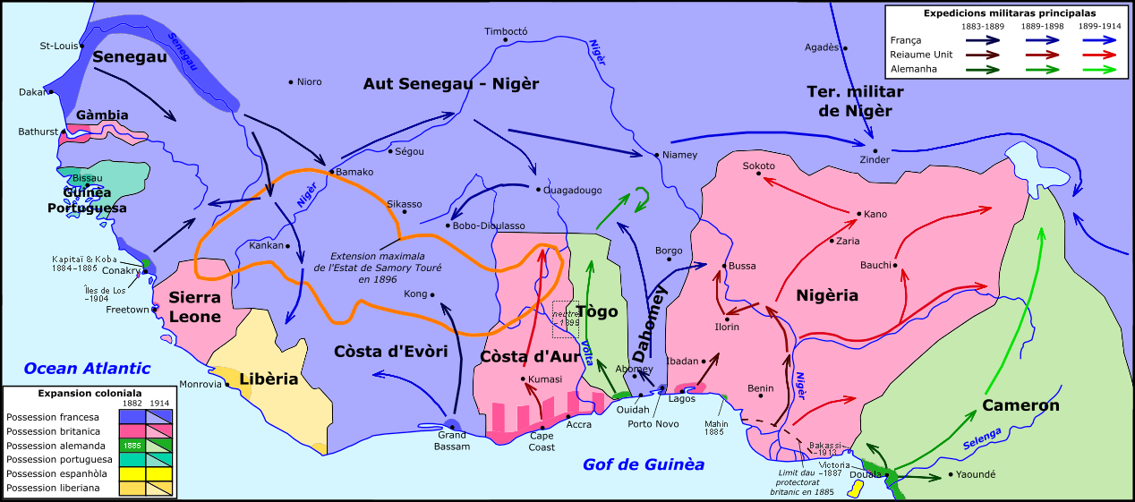
Occitan : Colonizacion de l'Africa Occidentala. English: Colonisation of West Africa, 1882-1914 |
| Date | |
| Source | Travail personnel |
| Auteur | Nicolas Eynaud |
Conditions d’utilisation[modifier]
Moi, en tant que détenteur des droits d’auteur sur cette œuvre, je la publie sous la licence suivante :
Ce fichier est sous la licence Creative Commons Attribution – Partage dans les Mêmes Conditions 4.0 International.
- Vous êtes libre :
- de partager – de copier, distribuer et transmettre cette œuvre
- d’adapter – de modifier cette œuvre
- Sous les conditions suivantes :
- paternité – Vous devez donner les informations appropriées concernant l'auteur, fournir un lien vers la licence et indiquer si des modifications ont été faites. Vous pouvez faire cela par tout moyen raisonnable, mais en aucune façon suggérant que l’auteur vous soutient ou approuve l’utilisation que vous en faites.
- partage à l’identique – Si vous modifiez, transformez, ou vous basez sur cette œuvre, vous devez distribuer votre contribution sous la même licence ou une licence compatible avec celle de l’original.
Historique du fichier
Cliquer sur une date et heure pour voir le fichier tel qu'il était à ce moment-là.
| Date et heure | Vignette | Dimensions | Utilisateur | Commentaire | |
|---|---|---|---|---|---|
| actuel | 17 septembre 2016 à 13:54 | | 1 268 × 561 (311 kio) | Chrischerf (d | contributions) | details, see discussion |
| 1 janvier 2016 à 12:10 |  | 1 268 × 561 (315 kio) | Nicolas Eynaud (d | contributions) | User created page with UploadWizard |
Vous ne pouvez pas remplacer ce fichier.
Utilisations locales du fichier
Aucune page n’utilise ce fichier.
Utilisations du fichier sur d’autres wikis
Les autres wikis suivants utilisent ce fichier :
- Utilisation sur ar.wikipedia.org
- Utilisation sur de.wikipedia.org
- Utilisation sur en.wikipedia.org
- Utilisation sur es.wikipedia.org
- Utilisation sur eu.wikipedia.org
- Utilisation sur fr.wikipedia.org
- Utilisation sur ja.wikipedia.org
- Utilisation sur mt.wikipedia.org
- Utilisation sur oc.wikipedia.org
- Utilisation sur ru.wikipedia.org
Métadonnées
Catégories :
- Maps of the history of Senegal
- Maps of the history of the Gambia
- Maps of the history of Guinea-Bissau
- Maps of the history of Guinea
- Maps of the history of Sierra Leone
- Maps of the history of Liberia
- Maps of the history of Ghana
- Maps of the history of Togo
- Maps of the history of Benin
- Maps of the history of Burkina Faso
- Maps of the history of Niger
- Maps of the history of Mali
- Maps of the history of Cameroon
- Maps of French West Africa
- Maps of former colonies of Germany in Africa
- Maps of British West Africa