File:Comanche County Oklahoma Incorporated areas highlighting Lawton.svg
Salta a la navegació
Salta a la cerca

Mida d'aquesta previsualització PNG del fitxer SVG: 582 × 599 píxels. Altres resolucions: 233 × 240 píxels | 466 × 480 píxels | 746 × 768 píxels | 995 × 1.024 píxels | 1.990 × 2.048 píxels.
Fitxer original (fitxer SVG, nominalment 582 × 599 píxels, mida del fitxer: 801 Ko)
Llegendes
Llegendes
Afegeix una explicació d'una línia del que representa aquest fitxer
Resum[modifica]
| Descripció |
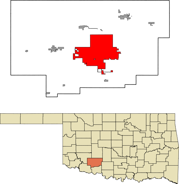
English: A map highlighting the city of Lawton in Comanche County in the US state of Oklahoma. Data provided from geo.ou.edu Based on similar maps from Ixnayonthetimmay |
| Data | |
| Font | Treball propi |
| Autor | Crimsonedge34 |
| SVG genesis | Aquesta imatge vectorial ha estat creada amb Inkscape. and with QGIS. |
Llicència[modifica]
Jo, el titular dels drets d'autor d'aquest treball, el public sota la següent llicència:
| L'ús d'aquest fitxer és regulat sota les condicions de Creative Commons de CC0 1.0 lliurament al domini públic universal. | |
| La persona que ha associat un treball amb aquest document ha dedicat l'obra domini públic, renunciant en tot el món a tots els seus drets de d'autor i a tots els drets legals relacionats que tenia en l'obra, en la mesura permesa per la llei. Podeu copiar, modificar, distribuir i modificar l'obra, fins i tot amb fins comercials, tot sense demanar permís.
|
Historial del fitxer
Cliqueu una data/hora per veure el fitxer tal com era aleshores.
| Data/hora | Miniatura | Dimensions | Usuari/a | Comentari | |
|---|---|---|---|---|---|
| actual | 07:47, 13 oct 2011 | | 582 × 599 (801 Ko) | Crimsonedge34 (discussió | contribucions) | Margins |
| 06:49, 13 oct 2011 |  | 692 × 646 (727 Ko) | Crimsonedge34 (discussió | contribucions) | Would help if I uploaded the correct map. | |
| 06:48, 13 oct 2011 |  | 1.052 × 744 (42 Ko) | Crimsonedge34 (discussió | contribucions) | {{Information |Description ={{en|1=A map highlighting the city of Lawton in Comanche County in the US state of Oklahoma. Based on similar maps from Ixnayonthetimmay}} |Source ={{own}} |Author =[[User:Crimso |
No podeu sobreescriure aquest fitxer.
Ús del fitxer
Les 3 pàgines següents utilitzen aquest fitxer:
Ús global del fitxer
Utilització d'aquest fitxer en altres wikis:
- Utilització a ar.wikipedia.org
- Utilització a arz.wikipedia.org
- Utilització a azb.wikipedia.org
- Utilització a br.wikipedia.org
- Utilització a ca.wikipedia.org
- Utilització a en.wikipedia.org
- Utilització a eu.wikipedia.org
- Utilització a fa.wikipedia.org
- Utilització a fi.wikipedia.org
- Utilització a fr.wikipedia.org
- Utilització a ga.wikipedia.org
- Utilització a gd.wikipedia.org
- Utilització a ht.wikipedia.org
- Utilització a hu.wikipedia.org
- Utilització a ia.wikipedia.org
- Utilització a id.wikipedia.org
- Utilització a kw.wikipedia.org
- Utilització a no.wikipedia.org
- Utilització a pt.wikipedia.org
- Utilització a sh.wikipedia.org
- Utilització a simple.wikipedia.org
- Utilització a sr.wikipedia.org
- Utilització a sv.wikipedia.org
- Utilització a tr.wikipedia.org
- Utilització a tt.wikipedia.org
- Utilització a ur.wikipedia.org
- Utilització a vo.wikipedia.org
- Utilització a www.wikidata.org
- Utilització a zh.wikipedia.org