File:Concord Retreat.png
跳转到导航
跳转到搜索
本预览的尺寸:800 × 342像素。 其他分辨率:320 × 137像素 | 640 × 273像素 | 1,024 × 437像素 | 1,280 × 546像素 | 3,235 × 1,381像素。
原始文件 (3,235 × 1,381像素,文件大小:780 KB,MIME类型:image/png)
说明
说明
添加一行文字以描述该文件所表现的内容
摘要
[编辑]| 描述 |
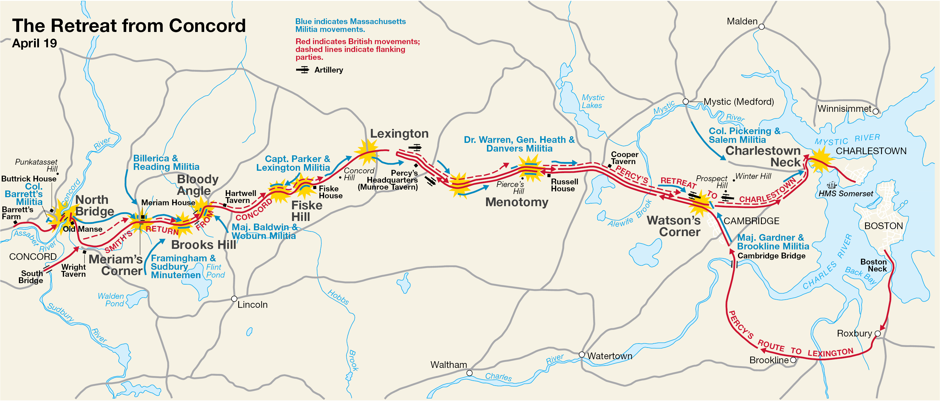
English: This is a map showing the route of the British army's 18-mile retreat from Concord to Charlestown in the Battles of Lexington and Concord on April 19, 1775. It shows the major points of conflict, as well as showing the route taken by Hugh, Earl Percy's reinforcements. |
| 日期 | 未知日期; source PDF created in 2000 |
| 来源 | http://data2.itc.nps.gov/parks/mima/ppMaps/MIMAmap2.pdf |
| 作者 | National Park Service |
| 其他版本 |
|

许可协议
[编辑]
| This image or media file contains material based on a work of a National Park Service employee, created as part of that person's official duties. As a work of the U.S. federal government, such work is in the public domain in the United States. See the NPS website and NPS copyright policy for more information. |
原始上传日志
[编辑]
Transferred from en.wikipedia to Commons by Andrei Stroe using CommonsHelper.
The original description page was here. All following user names refer to en.wikipedia.
- 2006-11-30 17:35 Irayo 3235×1381× (799048 bytes) The Retreat from Concord April 19 (1775) Minute Man National Historical Park Battle Map http://data2.itc.nps.gov/parks/mima/ppMaps/MIMAmap2.pdf {{PD-USGov-Interior-NPS}}
文件历史
点击某个日期/时间查看对应时刻的文件。
| 日期/时间 | 缩略图 | 大小 | 用户 | 备注 | |
|---|---|---|---|---|---|
| 当前 | 2010年11月29日 (一) 19:11 | | 3,235 × 1,381(780 KB) | File Upload Bot (Magnus Manske)(留言 | 贡献) | {{BotMoveToCommons|en.wikipedia|year={{subst:CURRENTYEAR}}|month={{subst:CURRENTMONTHNAME}}|day={{subst:CURRENTDAY}}}} {{Information |Description={{en|This is a map showing the route of the British army's 18-mile retreat from [[:en:Concord, Massachusetts |
您不可以覆盖此文件。
文件用途
以下页面使用本文件:
全域文件用途
以下其他wiki使用此文件:
- ar.wikipedia.org上的用途
- azb.wikipedia.org上的用途
- cs.wikipedia.org上的用途
- en.wikipedia.org上的用途
- es.wikipedia.org上的用途
- fr.wikipedia.org上的用途
- it.wikipedia.org上的用途
- ro.wikipedia.org上的用途
- ru.wikipedia.org上的用途
- th.wikipedia.org上的用途
- zh.wikipedia.org上的用途