File:Conical mound in trough on Mars' north pole.jpg
跳至導覽
跳至搜尋

預覽大小:800 × 548 像素。 其他解析度:320 × 219 像素 | 640 × 438 像素 | 1,024 × 702 像素 | 1,280 × 877 像素 | 1,734 × 1,188 像素。
原始檔案 (1,734 × 1,188 像素,檔案大小:1.23 MB,MIME 類型:image/jpeg)
說明
說明
添加單行說明來描述出檔案所代表的內容
摘要[編輯]
| 描述 |
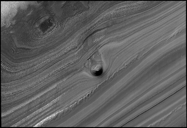
English: This striking image of a mound within the area of a trough cutting into Mars' north polar layered deposits was taken by the High Resolution Imaging Science Experiment (HiRISE) camera on NASA's Mars Reconnaissance Orbiter on September 2, 2008.
The north polar layered deposits are a stack of discernible layers that are rich in water-ice. The stack is up to several miles thick. Each layer is thought to contain information about the climate that existed when it was deposited. If true, the stack could represent a record of how climate has varied on Mars in the recent past. The internal layers are exposed in troughs and scarps where erosion has cut into the stack. The trough shown in this image contains a 1,640-foot thick section of the layering. A conical mound partway down the slope stands approximately 130 feet high. One possible explanation for this unusual mound is that it may be the remnant of a buried impact crater now being exhumed. As the north polar layered deposits accumulated, impacts occurred throughout their surface area, then the impact craters were buried by additional ice. These buried craters are generally inaccessible, but, in a few locations, erosion that forms a trough (like this one) can uncover these buried structures. For reasons poorly understood, the ice beneath the site of the crater is more resistant to this erosion, so when material is removed by erosion the ice beneath the old impact site remains, forming this isolated hill. |
| 日期 | |
| 來源 | NASA website; description,[1] high resolution image.[2] |
| 作者 | NASA/JPL-Caltech/University of Arizona |
![[2]](http://www.nasa.gov/images/content/283447main_PIA11231_full.jpg)
| 這是一張修飾過的圖片,即本圖片是用軟體修改過後的版本,修改的方式或內容有:Rotated source image。
|
授權條款[編輯]
| 本作品由NASA創作,屬於公有領域。根據NASA的版權政策:“NASA的創作除非另有聲明否則不受版權保護。”(參見:Template:PD-USGov/zh,NASA版權政策或JPL圖像使用政策) | ||
 |
警告:
|
檔案歷史
點選日期/時間以檢視該時間的檔案版本。
| 日期/時間 | 縮圖 | 尺寸 | 使用者 | 備註 | |
|---|---|---|---|---|---|
| 目前 | 2008年10月28日 (二) 11:31 | | 1,734 × 1,188(1.23 MB) | Elipongo(留言 | 貢獻) | {{Information |Description={{en|1=This striking image of a mound within the area of a trough cutting into Mars' north polar layered deposits was taken by the High Resolution Imaging Science Experiment (HiRISE) camera on NASA's [[Mars Reconnaissance Or |
無法覆蓋此檔案。
檔案用途
沒有使用此檔案的頁面。
全域檔案使用狀況
以下其他 wiki 使用了這個檔案:
- ca.wikipedia.org 的使用狀況
- de.wikipedia.org 的使用狀況
- en.wikipedia.org 的使用狀況
- es.wikipedia.org 的使用狀況
- lb.wikipedia.org 的使用狀況
- pnb.wikipedia.org 的使用狀況
- tr.wikipedia.org 的使用狀況
- ur.wikipedia.org 的使用狀況
- zh.wikipedia.org 的使用狀況