File:Continental pole of inaccessibility.png
跳转到导航
跳转到搜索

本预览的尺寸:600 × 600像素。 其他分辨率:240 × 240像素 | 480 × 480像素 | 960 × 960像素。
原始文件 (960 × 960像素,文件大小:152 KB,MIME类型:image/png)
说明
说明
添加一行文字以描述该文件所表现的内容
摘要
[编辑]

|
此map图片可使用矢量图形重新创建为SVG文件。这具有很多好处;更多信息请参见共享资源:待清理媒体。如果存在此图片的SVG格式,请将其上传,然后将此模板替换为
{{vector version available|新图片名称}}。
建议您将SVG命名为“Continental pole of inaccessibility.svg”,这样在使用Vector version available(或Vva)模板时就不需要填写新图片名称参数。 |
| 描述 |
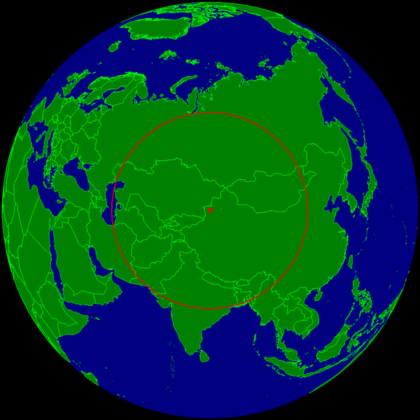
English: Spherical Earth centered on the continental pole of inaccessibility in the middle of Eurasia. The circle indicates the distance to the nearest ocean (the Caspian Sea on the left is not connected with the ocean).
Deutsch: Erdkugel, zentriert auf dem kontinentalen Pol der Unzugänglichkeit in der Mitte von Eurasien. Der Kreis zeigt den Abstand zum nächsten Ozean (das Kaspische Meer links im Bild ist nicht mit dem Ozean verbunden). |
| 日期 | |
| 来源 | 自己的作品 |
| 作者 | Timwi |
许可协议
[编辑]
| 我,本作品著作权人,释出本作品至公有领域。这适用于全世界。 在一些国家这可能不合法;如果是这样的话,那么: 我无条件地授予任何人以任何目的使用本作品的权利,除非这些条件是法律规定所必需的。 |
文件历史
点击某个日期/时间查看对应时刻的文件。
| 日期/时间 | 缩略图 | 大小 | 用户 | 备注 | |
|---|---|---|---|---|---|
| 当前 | 2015年3月24日 (二) 10:20 | | 960 × 960(152 KB) | RokerHRO(留言 | 贡献) | optipng -o7 -i0 → 29.75% decrease |
| 2008年7月25日 (五) 23:35 |  | 960 × 960(216 KB) | Timwi(留言 | 贡献) | {{Information |Description={{en|1=Spherical Earth centered on the continental pole of inaccessibility in the middle of Eurasia. The circle indicates the distance to the nearest ocean (the body of water on the left is not co |
您不可以覆盖此文件。
文件用途
以下页面使用本文件:
全域文件用途
以下其他wiki使用此文件:
- ast.wikipedia.org上的用途
- ca.wikipedia.org上的用途
- de.wikipedia.org上的用途
- en.wikipedia.org上的用途
- es.wikipedia.org上的用途
- et.wikipedia.org上的用途
- frr.wikipedia.org上的用途
- fr.wikipedia.org上的用途
- it.wikipedia.org上的用途
- ja.wikipedia.org上的用途
- lb.wikipedia.org上的用途
- pl.wikipedia.org上的用途
- pt.wikipedia.org上的用途
- ro.wikipedia.org上的用途
- sk.wikipedia.org上的用途
- uk.wikipedia.org上的用途
- vi.wikipedia.org上的用途
- www.wikidata.org上的用途
- zh.wikipedia.org上的用途