File:Corsica (Landsat 7).png
跳至導覽
跳至搜尋

預覽大小:370 × 600 像素。 其他解析度:148 × 240 像素 | 296 × 480 像素 | 474 × 768 像素 | 631 × 1,024 像素 | 1,263 × 2,048 像素 | 2,689 × 4,359 像素。
原始檔案 (2,689 × 4,359 像素,檔案大小:15.96 MB,MIME 類型:image/png)
說明
說明
添加單行說明來描述出檔案所代表的內容
摘要
[編輯].png&action=edit§ion=1)
Note: this image was scaled down to allow thumbnail generation, and brightness was slightly increased to enhance display on a computer screen. For the high-definition version, see File:Corsica (Landsat 7) - high definition.png.
_-_high_definition.png)
| 描述 |
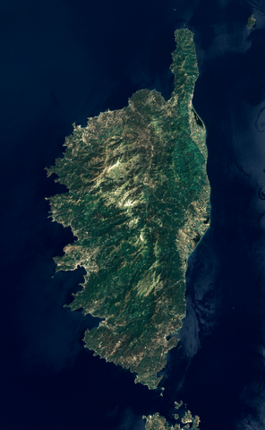
English: View of Corsica from the Landsat 7 satellite. This picture was built using data from the ETM+ instrument, by merging two datasets covering each half of the island. Bands 1, 2 and 3 (respectively blue, green and red) were combined to get a true-color image. Data from band 8 (panchromatic, visible + near infrared) was used as intensity value. Colors were then enhanced using an image manipulation program. Bands 1, 2 and 3 have a resolution of 30 m, and band 8 has a resolution of 15 m. Data was acquired on 2002-06-17. Most of the mountains thus lack snow, but névés can still be seen on highest peaks.
Français : Vue de la Corse depuis le satellite Landsat 7. Cette image a été obtenue à partir des données de l'instrument ETM+, en fusionnant deux ensembles de données pour couvrir toute la surface de l'île. Les bandes 1, 2 et 3 (correspondant respectivement aux couleurs bleu, vert, et rouge) ont été combinées pour former une image en couleurs réelles. Les données de la bande 8 (capteur panchromatique sensible à la fois aux couleurs visibles et à l'infrarouge proche) ont été utilisées comme valeurs d'intensité. Les couleurs ont ensuite été réajustées dans un logiciel de retouche d'image. La résolution des bandes 1, 2 et 3 (couleurs visibles) est de 30 m, et celle de la bande 8 est de 15 m. Les photos satellite ont été prises le 17 juin 2002. On peut constater l'absence de neige sur la plupart des montagnes corses, sauf quelques névés encore présents sur les plus hauts sommets. |
| 日期 | |
| 來源 | Data from USGS EarthExplorer. Links to metadata of individual images: LE71930312002168EDC00 and LE71930302002168EDC00 |
| 作者 |
|
| 其他版本 | File:Corsica (Landsat 7) - high definition.png (high-definition version) |
| 目標地點 | | 位於此地的本圖片與其他圖片: OpenStreetMap |
|---|
.png¶ms=042.163403_N_0009.129639_E_globe:Earth_class:object_type:object_region:FR_dim:220km_&language=zh-hk)
| 本作品由NASA創作,屬於公有領域。根據NASA的版權政策:“NASA的創作除非另有聲明否則不受版權保護。”(參見:Template:PD-USGov/zh,NASA版權政策或JPL圖像使用政策) | ||
 |
警告:
|
檔案歷史
點選日期/時間以檢視該時間的檔案版本。
| 日期/時間 | 縮圖 | 尺寸 | 用戶 | 備註 | |
|---|---|---|---|---|---|
| 目前 | 2011年9月28日 (三) 19:42 | | 2,689 × 4,359(15.96 MB) | Telperion(對話 | 貢獻) | removed bogus color profile |
| 2011年9月25日 (日) 13:22 |  | 2,689 × 4,359(16.02 MB) | Telperion(對話 | 貢獻) | small color correction | |
| 2011年9月24日 (六) 15:24 |  | 2,689 × 4,359(15.81 MB) | Telperion(對話 | 貢獻) | another try | |
| 2011年9月24日 (六) 15:10 |  | 2,843 × 4,609(17.51 MB) | Telperion(對話 | 貢獻) | {{Information |Description ={{en|1=View of Corsica from the Landsat 7 satellite. This picture was built using data from the ETM+ instrument, by merging two datasets covering each half of the island. Bands 1, 2 and 3 (r |
無法覆蓋此檔案。
檔案用途
下列6個頁面有用到此檔案:
全域檔案使用狀況
以下其他 wiki 使用了這個檔案:
- es.wikipedia.org 的使用狀況
- fr.wikipedia.org 的使用狀況
- fr.wikinews.org 的使用狀況
- Catégorie:15 mai 2008
- Catégorie:15 mai 2009
- Catégorie:15 mai 2010
- Catégorie:15 mai 2011
- Catégorie:15 mai 2012
- Modèle:Éphéméride-15 mai
- Évènements du 15 mai 2012
- Catégorie:15 mai 2013
- Évènements du 15 mai 2013
- Catégorie:15 mai 2014
- Évènements du 15 mai 2014
- Catégorie:15 mai 2015
- Évènements du 15 mai 2015
- Catégorie:15 mai 2016
- Évènements du 15 mai 2016
- Catégorie:15 mai 2017
- Évènements du 15 mai 2017
- Catégorie:15 mai 2018
- Évènements du 15 mai 2018
- Catégorie:15 mai 2019
- Évènements du 15 mai 2019
- Catégorie:15 mai 2020
- Évènements du 15 mai 2020
- Catégorie:15 mai 2021
- Catégorie:15 mai 2022
- Catégorie:15 mai 2023
- gcr.wikipedia.org 的使用狀況
- www.wikidata.org 的使用狀況
- zh.wikipedia.org 的使用狀況
.png&oldid=868730916)