File:Cryosphere Fuller Projection.png

Fichier d’origine (2 703 × 1 079 pixels, taille du fichier : 1,03 Mio, type MIME : image/png)
Légendes
Légendes
Description
[modifier]
| Description |
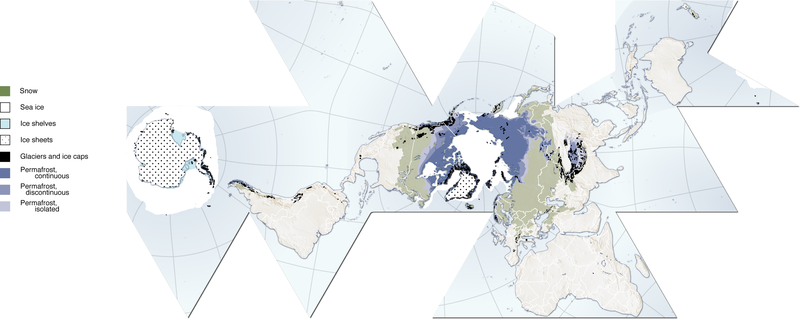
(Cryosphere) English: Author, Hugo Ahlenius, UNEP/GRID-Arendal. Full graphic, including sources, referencing etc are available here: http://maps.grida.no/go/graphic/cryosphere
.Image donated by author, no restrictions on use. Notes: Snow cover extent for Northern Hemisphere is represented by the 1966-2005 February average, for Southern Hemisphere by the 1987-2003 August average. Sea ice extent for Northern Hemisphere is represented by the 1979-2003 March average, for Southern Hemisphere by the 1979-2002 September average. Permafrost data for mountain areas and for the Southern Hemisphere are not represented in this map, neither are river and lake ice. Data sources: Armstrong, R.L. and Brodzik, M.J. (2005). Northern Hemisphere EASE-Grid weekly snow cover and sea ice extent version 3. (Digital media). National Snow and Ice Data Center, Boulder Armstrong, R.L., Brodzik, M.J., Knowles, K. and Savoie, M. (2005). Global monthly EASE-Grid snow water equivalent climatology. (Digital media). National Snow and Ice Data Center, Boulder Brown, J., Ferrians Jr., O.J., Heginbottom, J.A. and Melnikov, E.S. (1998 revised February 2001). Circum-Arctic map of permafrost and ground-ice conditions. (Digital media). National Snow and Ice Data Center/World Data Center for Glaciology, Boulder NGA (2000). Vector Map Level 0. National Geospatial-Intelligence Agency. http://geoengine.nima.mil/ftpdir/archive/vpf_ data/v0soa.tar.gz [Accessed 1 September 2006] Stroeve, J. and Meier, W. (1999, updated 2005). Sea Ice Trends and Climatologies from SMMR and SSM/I. National Snow and Ice Data Center. http://nsidc.org/data/smmr_ssmi_ ancillary/monthly_means.html [Accessed 20 April 2007] |
| Date | 12 juin 2007 (date de téléversement originale) |
| Source |
http://www.grida.no/graphicslib/detail/the-cryosphere-world-map_e290 Transféré de en.wikipedia à Commons par Pixeltoo utilisant CommonsHelper. |
| Auteur | Fraxen sur Wikipédia anglais |
Conditions d’utilisation
[modifier]

|
Vous avez la permission de copier, distribuer et modifier ce document selon les termes de la GNU Free Documentation License version 1.2 ou toute version ultérieure publiée par la Free Software Foundation, sans sections inaltérables, sans texte de première page de couverture et sans texte de dernière page de couverture. Un exemplaire de la licence est inclus dans la section intitulée GNU Free Documentation License. |
| Ce fichier est disponible selon les termes de la licence Creative Commons Attribution – Partage dans les Mêmes Conditions 3.0 (non transposée). | ||
| Attribution: Fraxen sur Wikipédia anglais | ||
| ||
| Ce bandeau de licence a été ajouté à ce fichier dans le cadre de la procédure de mise à jour des licences des images sous GFDL. |
- Vous êtes libre :
- de partager – de copier, distribuer et transmettre cette œuvre
- d’adapter – de modifier cette œuvre
- Sous les conditions suivantes :
- paternité – Vous devez donner les informations appropriées concernant l'auteur, fournir un lien vers la licence et indiquer si des modifications ont été faites. Vous pouvez faire cela par tout moyen raisonnable, mais en aucune façon suggérant que l’auteur vous soutient ou approuve l’utilisation que vous en faites.
- partage à l’identique – Si vous modifiez, transformez, ou vous basez sur cette œuvre, vous devez distribuer votre contribution sous la même licence ou une licence compatible avec celle de l’original.
Journal des téléversements d’origine
[modifier]
- 2007-06-12 08:06 Fraxen 2703×1079× (1080674 bytes)
- 2007-06-12 08:04 Fraxen 500×200× (73656 bytes)
- 2007-06-12 08:00 Fraxen 2703×1079× (1080674 bytes) Author, Hugo Ahlenius, UNEP/GRID-Arendal. Full graphic, including sources, referencing etc are available here: http://maps.grida.no/go/graphic/cryosphere Image donated by author, no restrictions on use. Notes: Snow cover extent for Northern Hemisphere is
Historique du fichier
Cliquer sur une date et heure pour voir le fichier tel qu'il était à ce moment-là.
| Date et heure | Vignette | Dimensions | Utilisateur | Commentaire | |
|---|---|---|---|---|---|
| actuel | 3 décembre 2014 à 16:48 | 2 703 × 1 079 (1,03 Mio) | Gabrielsanz (d | contributions) | Added the areas of glaciers and ice sheet in Sierra Nevada de Mérida (see Pico Bolívar, Pico Humboldt and [[Category:Glaciers of Venezuela|Glacier... | |
| 3 décembre 2014 à 15:57 | 2 703 × 1 079 (1,03 Mio) | Gabrielsanz (d | contributions) | Added the area of glaciers and ice cap located in Sierra Nevada de Mérida (see Pico Bolívar and Pico Humboldt) | ||
| 23 novembre 2008 à 10:56 | 2 703 × 1 079 (1,03 Mio) | File Upload Bot (Magnus Manske) (d | contributions) | {{BotMoveToCommons|en.wikipedia}} {{Information |Description={{en|Author, Hugo Ahlenius, UNEP/GRID-Arendal. Full graphic, including sources, referencing etc are available here: http://maps.grida.no/go/graphic/cryosphere Image donated by author, no restri |
Vous ne pouvez pas remplacer ce fichier.
Utilisations locales du fichier
Aucune page n’utilise ce fichier.
Utilisations du fichier sur d’autres wikis
Les autres wikis suivants utilisent ce fichier :
- Utilisation sur ar.wikipedia.org
- Utilisation sur ast.wikipedia.org
- Utilisation sur az.wikipedia.org
- Utilisation sur ca.wikipedia.org
- Utilisation sur el.wikipedia.org
- Utilisation sur en.wikipedia.org
- Utilisation sur en.wikiversity.org
- User:Marshallsumter/Rocks/Glaciers/Astroglaciology
- User:Marshallsumter/Rocks/Glaciers/Astroglaciology/Quiz
- Callisto/Quiz
- User:Marshallsumter/Rocks/Ice sheets/Europa/Quiz
- User:Marshallsumter/Rocks/Rocky objects/Ganymede/Quiz
- Stars/Solar systems/Quiz
- User:Marshallsumter/Rocks/Rocky objects/Earth
- Minerals/Ices/Brittle ices/Quiz
- User:Marshallsumter/Rocks/Glaciers/Quiz
- User:Marshallsumter/Rocks/Glaciers/Glaciology/Quiz
- User:Marshallsumter/Rocks/Ice sheets/Enceladus/Quiz
- Minerals/Ices/Black ices/Quiz
- Ice sheets/Quiz
- User:Marshallsumter/Radiation astronomy/Earth
- Utilisation sur es.wikipedia.org
- Utilisation sur et.wikipedia.org
- Utilisation sur eu.wikipedia.org
- Utilisation sur fa.wikipedia.org
- Utilisation sur fr.wikipedia.org
- Utilisation sur id.wikipedia.org
- Utilisation sur it.wikipedia.org
- Utilisation sur ja.wikipedia.org
- Utilisation sur ka.wikipedia.org
- Utilisation sur la.wikipedia.org
- Utilisation sur nn.wikipedia.org
- Utilisation sur om.wikipedia.org
- Utilisation sur ro.wikipedia.org
- Utilisation sur si.wikipedia.org
- Utilisation sur sr.wikipedia.org
- Utilisation sur th.wikipedia.org
- Utilisation sur tr.wikipedia.org
- Utilisation sur uk.wikipedia.org
- Utilisation sur ur.wikipedia.org
- Utilisation sur vi.wikipedia.org
- Utilisation sur zh.wikipedia.org
- Utilisation sur zu.wikipedia.org