File:Curiosity Rover Landing Site - Quadmapping Yellowknife.jpg
原始文件 (1,024 × 768像素,文件大小:173 KB,MIME类型:image/jpeg)
说明
说明
摘要
[编辑]
| 描述 |
English: 08.09.2012
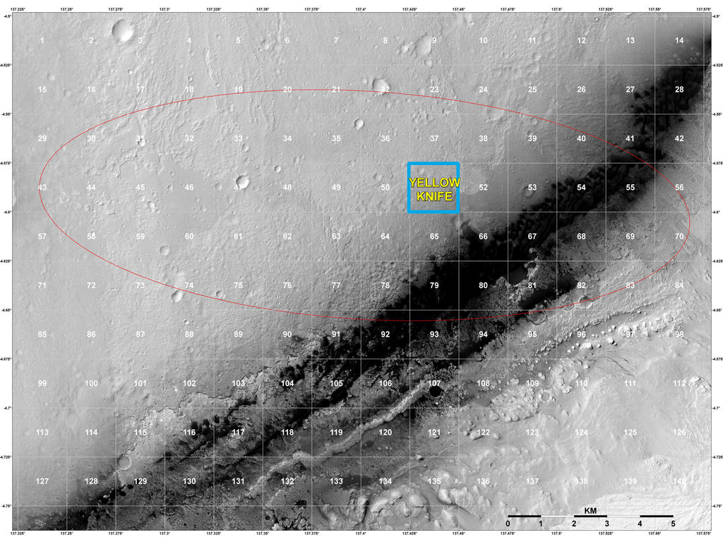
Staking out Curiosity's Landing Site The geological context for the landing site of NASA's Curiosity rover is visible in this image mosaic obtained by the High-Resolution Imaging Science Experiment (HiRISE) camera on NASA's Mars Reconnaissance Orbiter. The area around the landing site has been divided into square areas of interest about .9-mile (1.5-kilometers) wide. The mission has divided the surface into those quadrangles, or quads, so that groups of team members can focus their analysis on a particular part of the surface. Mt. Sharp is to the bottom right, out of the picture. HiRISE is one of six instruments on NASA's Mars Reconnaissance Orbiter. The University of Arizona, Tucson, operates the orbiter's HiRISE camera, which was built by Ball Aerospace & Technologies Corp., Boulder, Colo. NASA's Jet Propulsion Laboratory, a division of the California Institute of Technology in Pasadena, manages the Mars Reconnaissance Orbiter Project for the NASA Science Mission Directorate, Washington. Lockheed Martin Space Systems, Denver, built the spacecraft. Image Credit: NASA/JPL-Caltech/Univ. of Arizona |
| 日期 | |
| 来源 | http://mars.jpl.nasa.gov/msl/images/pia16031_Sumner_2MSL_Quadmapping_yellowknife-br2.jpg |
| 作者 | NASA/JPL-Caltech/Univ. of Arizona |
许可协议
[编辑]
| 本文件完全由NASA创作,在美国属于公有领域。根据NASA的版权方针,NASA的材料除非另有声明否则不受版权保护。(参见Template:PD-USGov/zh、NASA版权方针页面或JPL图片使用方针。) | ||
 |
警告:
|
文件历史
点击某个日期/时间查看对应时刻的文件。
| 日期/时间 | 缩略图 | 大小 | 用户 | 备注 | |
|---|---|---|---|---|---|
| 当前 | 2012年8月15日 (三) 18:30 | | 1,024 × 768(173 KB) | Drbogdan(留言 | 贡献) |
您不可以覆盖此文件。
文件用途
没有页面使用本文件。
全域文件用途
以下其他wiki使用此文件:
- bg.wikipedia.org上的用途
- bn.wikipedia.org上的用途
- ca.wikipedia.org上的用途
- en.wikipedia.org上的用途
- es.wikipedia.org上的用途
- fa.wikipedia.org上的用途
- it.wikipedia.org上的用途
- ja.wikipedia.org上的用途
- ko.wikipedia.org上的用途
- test.wikipedia.org上的用途
- tr.wikipedia.org上的用途
- uk.wikipedia.org上的用途
- zh.wikipedia.org上的用途