File:Custer Battlefield marked on the 1851 De Smet map of the Indian territories as defined in the Fort Laramie treaty (1851).png
Перейти к навигации
Перейти к поиску

Размер этого предпросмотра: 800 × 536 пкс. Другие разрешения: 320 × 214 пкс | 640 × 429 пкс | 1024 × 686 пкс | 1280 × 857 пкс | 2560 × 1714 пкс | 4255 × 2849 пкс.
Исходный файл (4255 × 2849 пкс, размер файла: 15,64 МБ, MIME-тип: image/png)
Краткие подписи
Краткие подписи
Добавьте однострочное описание того, что собой представляет этот файл
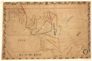
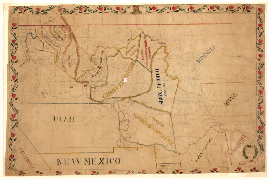
Father De Smets 1851 map of the native territories as put down in the Fort Laramie treaty (1851). The white X marks the Custer Battlefield at the Little Bighorn River (1876) in treaty defined territory of the Crow
Краткое описание
[править].png&action=edit§ion=1)
| Описание |
Dansk: De Smets forvrængede kort over de forskellige præriestammers territorier som fastlagt i 1851 med Fort Laramie traktaten. Custer slaget ved Little Bighorn River i 1876 mellem lakotaer og den amerikanske hær er markeret med hvidt. Kampen fandt sted i hjertet af et område anerkendt af lakotaerne som deres fjender i crow-stammens territorium i 1851
English: De Smets twisted map of the territories of the plains tribes as agreed upon in the Fort Laramie treaty (1851). The white X marks the Custer Battlefield at the Little Bighorn River (1876) between the Lakotas and the U.S. Army in the heart of a territory recognized by the Lakota as the land of their enemies in the Crow Nation in 1851 |
| Дата | |
| Источник | Library of Congress. hdl.loc.gov/loc.gmd/g4050.ct000883. “Map of the Upper Great Plains and Rocky Mountains region.” (The map is adapted to show the Custer Battlefield in Crow treaty defined territory (Fort Laramie Treaty 1851)) |
| Автор | Father De Smet (1801-1873). |
Лицензирование
[править].png&action=edit§ion=2)
Это произведение находится в общественном достоянии (англ. public domain) в США, так как оно было опубликовано до 1 января 1929 года.
Чтобы быть размещёнными на Викискладе, произведения в общественном достоянии не должны быть защищены авторским правом одновременно и в США, и в стране-источнике данного произведения. Если произведение опубликовано не в США, файл должен иметь дополнительный шаблон лицензии, показывающий его статус в стране-источнике с точки зрения охраны авторских прав.
|

|
This is a file uploaded through the Danish Wikipedia, which has not been reviewed on Commons:
|
История файла
Нажмите на дату/время, чтобы увидеть версию файла от того времени.
| Дата/время | Миниатюра | Размеры | Участник | Примечание | |
|---|---|---|---|---|---|
| текущий | 09:07, 18 сентября 2022 | | 4255 × 2849 (15,64 МБ) | Indianertosset (обсуждение | вклад) | Uploaded a work by Father De Smet (1801-1873). from Library of Congress. hdl.loc.gov/loc.gmd/g4050.ct000883. “Map of the Upper Great Plains and Rocky Mountains region.” (The map is adapted to show the Custer Battlefield in Crow treaty defined territory (Fort Laramie Treaty 1851)) with UploadWizard |
Вы не можете перезаписать этот файл.
Использование файла
Нет страниц, использующих этот файл.
Глобальное использование файла
Данный файл используется в следующих вики:
- Использование в da.wikipedia.org
.png&oldid=876389131)