File:Czechoslovakia IV.png
跳至導覽
跳至搜尋
預覽大小:800 × 364 像素。 其他解析度:320 × 146 像素 | 640 × 291 像素 | 1,128 × 513 像素。
原始檔案 (1,128 × 513 像素,檔案大小:130 KB,MIME 類型:image/png)
說明
說明
添加單行說明來描述出檔案所代表的內容
| 描述 |
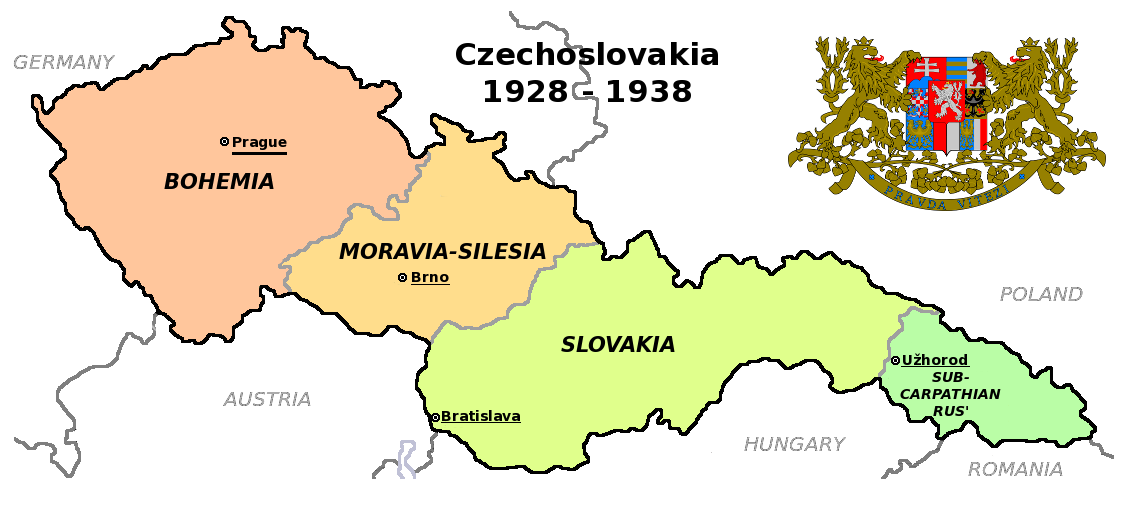
Čeština: Zemská mapa Československa v letech 1928 až 1938 s vyznačenými zemskými hlavními městy English: Maps of Czechoslovakia in 1928-1938 with marked borders of all four Czechoslovak lands and their regional capital cities |
| 日期 | (UTC) |
| 來源 | |
| 作者 |
|
| 其他版本 |
Derivative works of this file: |
| 這是一張修飾過的圖片,即本圖片是用軟體修改過後的版本,修改的方式或內容有:Simplified map。原版圖片來源:Czechoslovakia COA large.svg。修改者:Millenium187。
|
此檔案採用共享創意 姓名標示-相同方式分享 3.0 未在地化版本授權條款。
- 您可以自由:
- 分享 – 複製、發佈和傳播本作品
- 重新修改 – 創作演繹作品
- 惟需遵照下列條件:
- 姓名標示 – 您必須指名出正確的製作者,和提供授權條款的連結,以及表示是否有對內容上做出變更。您可以用任何合理的方式來行動,但不得以任何方式表明授權條款是對您許可或是由您所使用。
- 相同方式分享 – 如果您利用本素材進行再混合、轉換或創作,您必須基於如同原先的相同或兼容的條款,來分布您的貢獻成品。
原始上傳日誌
[編輯]
This image is a derivative work of the following images:
- File:Czechoslovakia01.png licensed with PD-self
- 2011-05-19T10:54:48Z PANONIAN 1128x513 (64020 Bytes) minor change, marked provincial capitals
- 2011-05-17T09:53:27Z PANONIAN 1128x513 (63994 Bytes) Reverted to version as of 10:38, 24 April 2011 - because this is map of Czechoslovakia and it was capital of Czechoslovakia
- 2011-05-17T05:07:38Z Millenium187 1128x513 (56086 Bytes) Why was Prague underlined and Vienna, Brno, Bratislava and other capital cities were not? -- corrected
- 2011-04-24T10:38:30Z PANONIAN 1128x513 (63994 Bytes) few corrections
- 2011-04-23T11:31:49Z PANONIAN 1128x509 (62348 Bytes) improved version
- 2008-12-20T20:58:14Z Kirk 1100x497 (80038 Bytes) {{Information |Description= |Source= |Date= |Author= |Permission= |other_versions= }}
- 2006-12-28T16:11:35Z Electionworld 1100x497 (92110 Bytes) {{ew|en|PANONIAN}} Map of {{link|Czechoslovakia}} (self made) Note: The provinces shown on the map were introduced by Act No. 125/1927 Zb. and became effective in 1928. {{PD-self}} [[Category:Maps of Czechoslovakia]] [[Cat
- File:Czechoslovakia_COA_large.svg licensed with Cc-by-sa-3.0-migrated, GFDL
- 2010-09-06T23:55:59Z Fry1989 635x350 (1316079 Bytes) Reverted to version as of 23:52, 6 September 2010 this version will have to stay, message me with any corrections you want and I'll see what I can do
- 2010-09-06T23:53:49Z Kwasura 635x350 (1440388 Bytes) correction
- 2010-09-06T23:52:33Z Fry1989 635x350 (1316079 Bytes) lets see if it'll upload for me, checks out fine in inkscape
- 2010-09-06T23:50:19Z Kwasura 635x350 (1440373 Bytes) correction
- 2010-08-12T19:52:16Z Delta 51 635x350 (1440480 Bytes) Reverted to version as of 08:13, 5 November 2006 (the new versions don't work at all)
- 2010-08-09T20:16:25Z Kwasura 635x350 (1026422 Bytes) trying
- 2010-08-09T20:06:57Z Kwasura 635x350 (1976 Bytes) well, I just don't know how to do it...
- 2010-08-09T20:05:24Z Kwasura 635x350 (1976 Bytes) one more try
- 2010-08-09T20:02:09Z Kwasura 635x350 (1976 Bytes) correction 2nd try
- 2010-08-09T19:57:24Z Kwasura 635x350 (1976 Bytes) correction
- 2006-11-05T08:13:30Z Happenstance 635x350 (1440480 Bytes) crowns for the eagles
- 2006-06-17T05:00:05Z Happenstance 635x350 (1439900 Bytes) ==Author:== * commons: [[user:Shazz|Shazz]] * pl.wiki: [[w:pl:user:Shazz|Shazz]] ==Description== * '''cs:''' Znak Československa - velký * '''pl:''' Godło Czechosłowacji - duże * '''en:''' Coat of Arms of Czechoslovakia
Uploaded with derivativeFX
檔案歷史
點選日期/時間以檢視該時間的檔案版本。
| 日期/時間 | 縮圖 | 尺寸 | 用戶 | 備註 | |
|---|---|---|---|---|---|
| 目前 | 2011年8月12日 (五) 18:36 | | 1,128 × 513(130 KB) | Millenium187(對話 | 貢獻) | {{Information |Description={{cs|Zemská mapa Československa v letech 1928 až 1938}} {{en|Maps of Czechoslovakia in 1928-1938 with marked borders of all four Czechoslovak countries}} |Source=*File:Czechoslovakia01.png *[[:File:Czechoslovakia_COA_l |
無法覆蓋此檔案。
檔案用途
全域檔案使用狀況
以下其他 wiki 使用了這個檔案:
- ca.wikipedia.org 的使用狀況
- en.wikipedia.org 的使用狀況
- fa.wikipedia.org 的使用狀況
- fr.wikipedia.org 的使用狀況
- ps.wikipedia.org 的使用狀況