File:D-A-Independent inter-city rail.png
ナビゲーションに移動
検索に移動

このプレビューのサイズ: 517 × 600 ピクセル。 その他の解像度: 207 × 240 ピクセル | 414 × 480 ピクセル | 662 × 768 ピクセル | 882 × 1,024 ピクセル | 1,814 × 2,105 ピクセル。
元のファイル (1,814 × 2,105 ピクセル、ファイルサイズ: 1.21メガバイト、MIME タイプ: image/png)
キャプション
キャプション
このファイルの内容を1行で記述してください
概要[編集]
| 解説 |
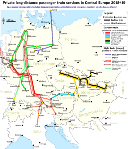
English: The map shows lines of regularly operated long-distance / inter-city passenger rail services from or to destinations in Central Europe. The open-access passenger rail services are self-sufficient and run by privately owned railway companies for profit. The rail services are being run in competition with public-sector (i.e. public body or state-owned) passenger railway companies. Companies being fully or by majority owned by the public sector are excluded from the map (as an example, Arriva plc is 100% owned by German state-owned rail company DB AG and operating all over Europe except Germany - this DB AG passenger rail company and all of its subsidiaries in which Arriva holds the majority are excluded from the map). Also excluded from the map are (i.) rail charters, (ii.) motorail services without the possibility to travel without car or motorbike and also (iii.) long-distance passenger rail services that are procured through public bodies and financed through franchise contracts (no self-sufficient operation) - plus finally (iv.) short-distance services (like shuttles, commuter trains, metros, etc...) of any kind. The map includes all-year round daylight services as well as seasonal / all-year night trains. The operation frequency covers everything between a mimimum of one connection per week up to multiple connections each day (even in the case of seasonal offers). The map shows - in different colors - the different railway lines. Branched railway lines share the same colour as their parent line. For more details, see the legend. |
| 日付 | |
| 原典 | 投稿者自身による著作物 |
| 作者 | Metrancya |
| その他のバージョン | D-A-Wettbewerber-EVU.png (geman-language version of this map) |
ライセンス[編集]
この作品の著作権者である私は、この作品を以下のライセンスで提供します。
このファイルはクリエイティブ・コモンズ 表示 4.0 国際ライセンスのもとに利用を許諾されています。
- あなたは以下の条件に従う場合に限り、自由に
- 共有 – 本作品を複製、頒布、展示、実演できます。
- 再構成 – 二次的著作物を作成できます。
- あなたの従うべき条件は以下の通りです。
- 表示 – あなたは適切なクレジットを表示し、ライセンスへのリンクを提供し、変更があったらその旨を示さなければなりません。これらは合理的であればどのような方法で行っても構いませんが、許諾者があなたやあなたの利用行為を支持していると示唆するような方法は除きます。
ファイルの履歴
過去の版のファイルを表示するには、その版の日時をクリックしてください。
| 日付と時刻 | サムネイル | 寸法 | 利用者 | コメント | |
|---|---|---|---|---|---|
| 現在の版 | 2018年12月11日 (火) 23:48 | | 1,814 × 2,105 (1.21メガバイト) | Metrancya (トーク | 投稿記録) | 2019 update, mainly winter 18/19 |
| 2018年5月16日 (水) 21:24 |  | 1,814 × 2,105 (1.2メガバイト) | Metrancya (トーク | 投稿記録) | Flixtrain is expanding, now operating the former network of Locomore, HKX, Leo Express (all in Germany), doing cooperations with Westbahn, LEO Express and BTE. Several adjustnets made to account for the UEX urlaubs-Express network in winter 18/19. Included planned connections for 2019. | |
| 2018年3月7日 (水) 17:03 |  | 1,814 × 2,105 (1.22メガバイト) | Metrancya (トーク | 投稿記録) | Locomore and HKX stopped running in Germany. They are now being replaced by Flixtrain in March / April 2018. Flixtrain is a brand name. Under the hood, BTE and LEO Express still operate the trains. | |
| 2017年11月15日 (水) 22:10 |  | 1,814 × 2,105 (1.15メガバイト) | Metrancya (トーク | 投稿記録) | Euro-Express and BTE Autoreisezug no longer offer passenger night services w/o cars. New connections by UEX. Regiojet nighttrain going to Humenné instead of Kosice. | |
| 2017年10月23日 (月) 01:53 |  | 1,814 × 2,105 (1.19メガバイト) | Metrancya (トーク | 投稿記録) | 2018 updates: +Prague-Vienna, +Prague-Krakow, -Düsseldorf-Livorno, +Hamburg-Landeck (winter), more train stations. The brand name Locomore finally vanished and was replaced by LEO Express. | |
| 2017年8月8日 (火) 17:39 |  | 1,814 × 2,105 (1.2メガバイト) | Metrancya (トーク | 投稿記録) | General update. Extended map to include Central Europe. Contains motorail terminals for some night trains. LEO Express took over Locomore, new trains scheduled for 18 August 2017. THX to https://www.drehscheibe-online.de/foren/read.php?002,8265204,page... | |
| 2017年5月22日 (月) 23:32 |  | 1,108 × 1,651 (672キロバイト) | Metrancya (トーク | 投稿記録) | general update | |
| 2016年12月29日 (木) 15:20 |  | 1,112 × 1,503 (532キロバイト) | Metrancya (トーク | 投稿記録) | visibility enhancements | |
| 2016年12月29日 (木) 01:20 |  | 1,112 × 1,503 (472キロバイト) | Metrancya (トーク | 投稿記録) | more rail lines | |
| 2016年12月17日 (土) 04:00 |  | 1,112 × 1,499 (415キロバイト) | Metrancya (トーク | 投稿記録) | addressing small translation error |
このファイルは上書きできません。
ファイルの使用状況
以下の 36 ページがこのファイルを使用しています:
- User:Chumwa/OgreBot/Potential transport maps/2016 December 11-20
- User:Chumwa/OgreBot/Potential transport maps/2016 December 21-31
- User:Chumwa/OgreBot/Potential transport maps/2017 August 1-10
- User:Chumwa/OgreBot/Potential transport maps/2017 May 21-31
- User:Chumwa/OgreBot/Potential transport maps/2017 November 11-20
- User:Chumwa/OgreBot/Potential transport maps/2017 October 21-31
- User:Chumwa/OgreBot/Potential transport maps/2018 December 11-20
- User:Chumwa/OgreBot/Potential transport maps/2018 March 1-10
- User:Chumwa/OgreBot/Potential transport maps/2018 May 11-20
- User:Chumwa/OgreBot/Public transport information/2016 December 11-20
- User:Chumwa/OgreBot/Public transport information/2016 December 21-31
- User:Chumwa/OgreBot/Public transport information/2017 August 1-10
- User:Chumwa/OgreBot/Public transport information/2017 May 21-31
- User:Chumwa/OgreBot/Public transport information/2017 November 11-20
- User:Chumwa/OgreBot/Public transport information/2017 October 21-31
- User:Chumwa/OgreBot/Public transport information/2018 December 11-20
- User:Chumwa/OgreBot/Public transport information/2018 March 1-10
- User:Chumwa/OgreBot/Public transport information/2018 May 11-20
- User:Chumwa/OgreBot/Transport Maps/2016 December 11-20
- User:Chumwa/OgreBot/Transport Maps/2016 December 21-31
- User:Chumwa/OgreBot/Transport Maps/2017 August 1-10
- User:Chumwa/OgreBot/Transport Maps/2017 May 21-31
- User:Chumwa/OgreBot/Transport Maps/2017 November 11-20
- User:Chumwa/OgreBot/Transport Maps/2017 October 21-31
- User:Chumwa/OgreBot/Transport Maps/2018 December 11-20
- User:Chumwa/OgreBot/Transport Maps/2018 March 1-10
- User:Chumwa/OgreBot/Transport Maps/2018 May 11-20
- User:Chumwa/OgreBot/Travel and communication maps/2016 December 11-20
- User:Chumwa/OgreBot/Travel and communication maps/2016 December 21-31
- User:Chumwa/OgreBot/Travel and communication maps/2017 August 1-10
- User:Chumwa/OgreBot/Travel and communication maps/2017 May 21-31
- User:Chumwa/OgreBot/Travel and communication maps/2017 November 11-20
- User:Chumwa/OgreBot/Travel and communication maps/2017 October 21-31
- User:Chumwa/OgreBot/Travel and communication maps/2018 December 11-20
- User:Chumwa/OgreBot/Travel and communication maps/2018 March 1-10
- User:Chumwa/OgreBot/Travel and communication maps/2018 May 11-20
グローバルなファイル使用状況
以下に挙げる他のウィキがこの画像を使っています:
- cs.wikipedia.org での使用状況
- en.wikipedia.org での使用状況
- it.wikipedia.org での使用状況
- ja.wikipedia.org での使用状況
- uk.wikipedia.org での使用状況