File:DG Ariel Plantation.jpg
跳转到导航
跳转到搜索

本预览的尺寸:750 × 600像素。 其他分辨率:300 × 240像素 | 600 × 480像素 | 960 × 768像素 | 1,280 × 1,024像素 | 1,500 × 1,200像素。
原始文件 (1,500 × 1,200像素,文件大小:162 KB,MIME类型:image/jpeg)
说明
说明
添加一行文字以描述该文件所表现的内容
摘要[编辑]
| 描述 |
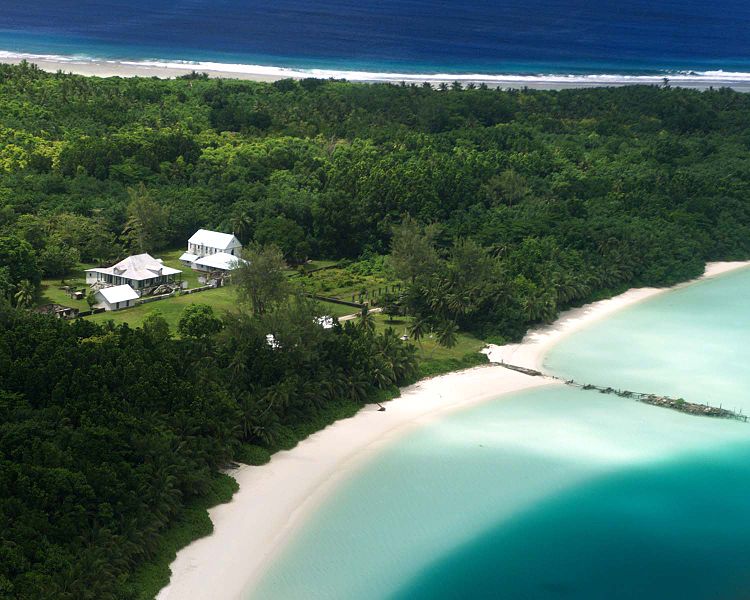
English: Aerial photograph of the coconut plantation at East Point, Diego Garcia. Photograph shows strip of land between both ocean and lagoon.
The island hosts a large airstrip used by the U.S. Armed forces during the Gulf war for operating B-52s. U.S. Submarines and Navy Seal teams have also populated the island in the past. In 1986 The USS Saratoga (CV 60) was docked at the island when it was called away to respond to threats by Lybian Leader Momar Kadaffi and the "Line of Death" in the Gulf of Sidra (also known as the Gulf of Sirte). The carrier left its port while many of its ±4500 sailors were still on the island, which subsequently had to be airlifted via helicopter as the ship made its way to the Mediterranean. The Saratoga spearheaded the assault on the African Nation. |
| 来源 | |
| 作者 |
许可协议[编辑]
此作品在美国属于公有领域,因为其是由美国政府的官员或雇员,基于其个人公务目的制作的作品,参考美国法典第17篇第1章第105条。
注意︰本模板仅适用于美国联邦政府的原创作品,不适用于任何美国州、属地、联邦个体、县、市或任何次级政府的作品。本模板也不适用于1978年以后由美国邮政署出版的邮票图案(参看美国版权局实践纲领第313.6(C)(1)条)。也不适用于部分美国硬币;参看美国铸币局使用条款。 |
 | |
| 本文件已被确认为免除已知的著作权法限制(包括所有相关权利)。 | ||
原始上传日志[编辑]
The original description page was here. All following user names refer to en.wikipedia.
- 2005-12-27 07:37 Jgrimmer 1500×1200×8 (166195 bytes) Ariel photograph of the coconut plantation at East Point, Diego Garcia. Photograph shows stip of land between both ocean and lagoon.
文件历史
点击某个日期/时间查看对应时刻的文件。
| 日期/时间 | 缩略图 | 大小 | 用户 | 备注 | |
|---|---|---|---|---|---|
| 当前 | 2008年4月20日 (日) 13:00 | | 1,500 × 1,200(162 KB) | File Upload Bot (Magnus Manske)(留言 | 贡献) | {{BotMoveToCommons|en.wikipedia}} {{Information |Description={{en|Aerial photograph of the coconut plantation at East Point, Diego Garcia. Photograph shows strip of land between both ocean and lagoon. The island hosts a large airstrip used by the U.S. |
您不可以覆盖此文件。
文件用途
以下页面使用本文件:
全域文件用途
以下其他wiki使用此文件:
- ast.wikipedia.org上的用途
- be.wikipedia.org上的用途
- ca.wikipedia.org上的用途
- ceb.wikipedia.org上的用途
- cy.wikipedia.org上的用途
- en.wikipedia.org上的用途
- eo.wikipedia.org上的用途
- es.wikipedia.org上的用途
- fa.wikipedia.org上的用途
- fr.wikipedia.org上的用途
- ga.wikipedia.org上的用途
- gl.wikipedia.org上的用途
- he.wikipedia.org上的用途
- hi.wikipedia.org上的用途
- it.wikipedia.org上的用途
- mk.wikipedia.org上的用途
- ml.wikipedia.org上的用途
- mn.wikipedia.org上的用途
- ne.wikipedia.org上的用途
- nl.wikipedia.org上的用途
- no.wikipedia.org上的用途
- os.wikipedia.org上的用途
- pt.wikipedia.org上的用途
- sh.wikipedia.org上的用途
- simple.wikipedia.org上的用途
- sr.wikipedia.org上的用途
- ta.wikipedia.org上的用途
- uk.wikipedia.org上的用途
- www.wikidata.org上的用途
- zh.wikipedia.org上的用途