File:DST Countries Map.png
跳转到导航
跳转到搜索

本预览的尺寸:800 × 355像素。 其他分辨率:320 × 142像素 | 640 × 284像素 | 1,024 × 454像素 | 1,280 × 568像素 | 2,560 × 1,136像素 | 4,952 × 2,197像素。
原始文件 (4,952 × 2,197像素,文件大小:462 KB,MIME类型:image/png)
说明
说明
添加一行文字以描述该文件所表现的内容
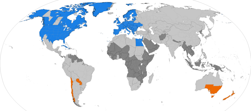
Countries that observe Daylight Saving Time
Dark grey places have never used daylight savings, light grey places formerly used it. Orange places use daylight savings in the southern hemisphere summer. Blue places use daylight savings in the northern hemisphere summer.

|
该文件可能会更新以反映新信息 如果您希望在不镜像新更新的情况下使用该文件的特定版本,请将所需版本作为单独的文件上传。 |

|
此map of the world图片可使用矢量图形重新创建为SVG文件。这具有很多好处;更多信息请参见共享资源:待清理媒体。如果存在此图片的SVG格式,请将其上传,然后将此模板替换为
{{vector version available|新图片名称}}。
建议您将SVG命名为“DST Countries Map.svg”,这样在使用Vector version available(或Vva)模板时就不需要填写新图片名称参数。 |
摘要[编辑]
| 描述 |
English: Larger map of the previous version. Distinguished from summertime in the northern hemisphere and southern hemisphere.
Northern hemisphere summer
Southern hemisphere summer
Formerly used daylight savings
Never used daylight savings |
| 日期 | |
| 来源 | 自己的作品 |
| 作者 | TimeZonesBoy |
| 其他版本 |
Supplementary map: |

许可协议[编辑]
我,本作品著作权人,特此采用以下许可协议发表本作品:
本文件采用知识共享署名-相同方式共享 3.0 未本地化版本许可协议授权。
- 您可以自由地:
- 共享 – 复制、发行并传播本作品
- 修改 – 改编作品
- 惟须遵守下列条件:
- 署名 – 您必须对作品进行署名,提供授权条款的链接,并说明是否对原始内容进行了更改。您可以用任何合理的方式来署名,但不得以任何方式表明许可人认可您或您的使用。
- 相同方式共享 – 如果您再混合、转换或者基于本作品进行创作,您必须以与原先许可协议相同或相兼容的许可协议分发您贡献的作品。
文件历史
点击某个日期/时间查看对应时刻的文件。
| 日期/时间 | 缩略图 | 大小 | 用户 | 备注 | |
|---|---|---|---|---|---|
| 当前 | 2024年3月31日 (日) 06:06 | | 4,952 × 2,197(462 KB) | Heitordp(留言 | 贡献) | Adjusted Greenland |
| 2023年12月31日 (日) 11:27 |  | 4,952 × 2,197(462 KB) | Heitordp(留言 | 贡献) | Updated Greenland, disputed borders, subdivisions of France, Morocco, DR Congo, South Sudan, Ethiopia, Somalia, India | |
| 2023年4月23日 (日) 09:44 |  | 4,952 × 2,197(463 KB) | Heitordp(留言 | 贡献) | Updated Ukraine | |
| 2023年4月5日 (三) 21:51 |  | 4,952 × 2,197(463 KB) | Heitordp(留言 | 贡献) | Updated most of Greenland, law specifies UTC–2 with no DST in 2023 | |
| 2023年3月27日 (一) 13:30 |  | 4,952 × 2,197(462 KB) | Heitordp(留言 | 贡献) | Corrected northeast Greenland and Qikiqtaaluk island | |
| 2023年3月1日 (三) 20:58 |  | 4,952 × 2,197(462 KB) | Heitordp(留言 | 贡献) | Updated Egypt, adjusted Kazakhstan | |
| 2022年11月30日 (三) 06:48 |  | 4,952 × 2,197(462 KB) | Heitordp(留言 | 贡献) | Updated Mexico | |
| 2022年11月20日 (日) 08:01 |  | 4,952 × 2,197(462 KB) | Heitordp(留言 | 贡献) | Removed Antarctica, added globe outline | |
| 2022年10月30日 (日) 09:29 |  | 4,972 × 2,492(466 KB) | Heitordp(留言 | 贡献) | Updated Mexico; adjusted US, Canada, Greenland | |
| 2022年10月6日 (四) 02:02 |  | 4,972 × 2,492(466 KB) | Heitordp(留言 | 贡献) | Updated Jordan and Syria |
您不可以覆盖此文件。
文件用途
以下42个页面使用本文件:
- User:Chumwa/OgreBot/Potential transport maps/2016 April 21-30
- User:Chumwa/OgreBot/Potential transport maps/2016 December 1-10
- User:Chumwa/OgreBot/Potential transport maps/2016 December 21-31
- User:Chumwa/OgreBot/Potential transport maps/2016 July 1-10
- User:Chumwa/OgreBot/Potential transport maps/2016 March 11-20
- User:Chumwa/OgreBot/Potential transport maps/2016 October 11-20
- User:Chumwa/OgreBot/Potential transport maps/2016 October 21-31
- User:Chumwa/OgreBot/Potential transport maps/2016 September 1-10
- User:Chumwa/OgreBot/Potential transport maps/2016 September 11-20
- User:Chumwa/OgreBot/Potential transport maps/2016 September 21-30
- User:Chumwa/OgreBot/Potential transport maps/2017 February 1-9
- User:Chumwa/OgreBot/Potential transport maps/2017 March 11-20
- User:Chumwa/OgreBot/Transport Maps/2015 April 21-30
- User:Chumwa/OgreBot/Transport Maps/2015 July 1-10
- User:Chumwa/OgreBot/Transport Maps/2015 June 21-30
- User:Chumwa/OgreBot/Transport Maps/2015 March 11-20
- User:Chumwa/OgreBot/Transport Maps/2015 May 11-20
- User:Chumwa/OgreBot/Transport Maps/2016 April 21-30
- User:Chumwa/OgreBot/Transport Maps/2016 December 1-10
- User:Chumwa/OgreBot/Transport Maps/2016 December 21-31
- User:Chumwa/OgreBot/Transport Maps/2016 July 1-10
- User:Chumwa/OgreBot/Transport Maps/2016 March 11-20
- User:Chumwa/OgreBot/Transport Maps/2016 October 11-20
- User:Chumwa/OgreBot/Transport Maps/2016 October 21-31
- User:Chumwa/OgreBot/Transport Maps/2016 September 1-10
- User:Chumwa/OgreBot/Transport Maps/2016 September 11-20
- User:Chumwa/OgreBot/Transport Maps/2016 September 21-30
- User:Chumwa/OgreBot/Transport Maps/2017 February 1-9
- User:Chumwa/OgreBot/Transport Maps/2017 March 11-20
- User:Chumwa/OgreBot/Travel and communication maps/2016 April 21-30
- User:Chumwa/OgreBot/Travel and communication maps/2016 December 1-10
- User:Chumwa/OgreBot/Travel and communication maps/2016 December 21-31
- User:Chumwa/OgreBot/Travel and communication maps/2016 July 1-10
- User:Chumwa/OgreBot/Travel and communication maps/2016 March 11-20
- User:Chumwa/OgreBot/Travel and communication maps/2016 October 11-20
- User:Chumwa/OgreBot/Travel and communication maps/2016 October 21-31
- User:Chumwa/OgreBot/Travel and communication maps/2016 September 1-10
- User:Chumwa/OgreBot/Travel and communication maps/2016 September 11-20
- User:Chumwa/OgreBot/Travel and communication maps/2016 September 21-30
- User:Chumwa/OgreBot/Travel and communication maps/2017 February 1-9
- User:Chumwa/OgreBot/Travel and communication maps/2017 March 11-20
- File:DaylightSaving-World-Subdivisions.png
全域文件用途
以下其他wiki使用此文件:
- ar.wikipedia.org上的用途
- azb.wikipedia.org上的用途
- bs.wikipedia.org上的用途
- en.wikipedia.org上的用途
- es.wikipedia.org上的用途
- fa.wikipedia.org上的用途
- ga.wikipedia.org上的用途
- hu.wikipedia.org上的用途
- hy.wikipedia.org上的用途
- ja.wikipedia.org上的用途
- lt.wikipedia.org上的用途
- pnb.wikipedia.org上的用途
- ru.wikipedia.org上的用途
- sh.wikipedia.org上的用途
- simple.wikipedia.org上的用途
- sq.wikipedia.org上的用途
- sr.wikipedia.org上的用途
- ta.wikipedia.org上的用途
- tr.wikipedia.org上的用途
- vi.wikipedia.org上的用途
- zh.wikipedia.org上的用途