File:DST Countries Map.png
跳至導覽
跳至搜尋

預覽大小:800 × 355 像素。 其他解析度:320 × 142 像素 | 640 × 284 像素 | 1,024 × 454 像素 | 1,280 × 568 像素 | 2,560 × 1,136 像素 | 4,952 × 2,197 像素。
原始檔案 (4,952 × 2,197 像素,檔案大小:462 KB,MIME 類型:image/png)
說明
說明
添加單行說明來描述出檔案所代表的內容
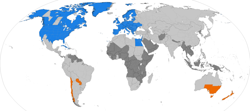
Countries that observe Daylight Saving Time
Dark grey places have never used daylight savings, light grey places formerly used it. Orange places use daylight savings in the southern hemisphere summer. Blue places use daylight savings in the northern hemisphere summer.

|
This file may be updated to reflect new information. If you wish to use a specific version of the file without new updates being mirrored, please upload the required version as a separate file. |

|
本圖片是以PNG、GIF或JPEG格式上傳。然而,其中包含的資料或訊息,應該重新建立成可縮放向量圖形(SVG)檔案,以更有效率或更準確的方式儲存。如有可能,請上傳本圖片的SVG格式版本。在上傳之後,請修改維基各姊妹計畫中所有使用舊版圖片的條目(列在圖像連結章節中),替換為新版圖片,並在舊圖片的描述頁中加入{{Vector version available|新圖片名稱.svg}}模板,同時移除本模板。
|
摘要[編輯]
| 描述 |
English: Larger map of the previous version. Distinguished from summertime in the northern hemisphere and southern hemisphere.
Northern hemisphere summer
Southern hemisphere summer
Formerly used daylight savings
Never used daylight savings |
| 日期 | |
| 來源 | 自己的作品 |
| 作者 | TimeZonesBoy |
| 其他版本 |
Supplementary map: |

授權條款[編輯]
我,本作品的著作權持有者,決定用以下授權條款發佈本作品:
此檔案採用共享創意 姓名標示-相同方式分享 3.0 未在地化版本授權條款。
- 您可以自由:
- 分享 – 複製、發佈和傳播本作品
- 重新修改 – 創作演繹作品
- 惟需遵照下列條件:
- 姓名標示 – 您必須指名出正確的製作者,和提供授權條款的連結,以及表示是否有對內容上做出變更。您可以用任何合理的方式來行動,但不得以任何方式表明授權條款是對您許可或是由您所使用。
- 相同方式分享 – 如果您利用本素材進行再混合、轉換或創作,您必須基於如同原先的相同或兼容的條款,來分布您的貢獻成品。
檔案歷史
點選日期/時間以檢視該時間的檔案版本。
| 日期/時間 | 縮圖 | 尺寸 | 用戶 | 備註 | |
|---|---|---|---|---|---|
| 目前 | 2024年3月31日 (日) 06:06 | | 4,952 × 2,197(462 KB) | Heitordp(對話 | 貢獻) | Adjusted Greenland |
| 2023年12月31日 (日) 11:27 |  | 4,952 × 2,197(462 KB) | Heitordp(對話 | 貢獻) | Updated Greenland, disputed borders, subdivisions of France, Morocco, DR Congo, South Sudan, Ethiopia, Somalia, India | |
| 2023年4月23日 (日) 09:44 |  | 4,952 × 2,197(463 KB) | Heitordp(對話 | 貢獻) | Updated Ukraine | |
| 2023年4月5日 (三) 21:51 |  | 4,952 × 2,197(463 KB) | Heitordp(對話 | 貢獻) | Updated most of Greenland, law specifies UTC–2 with no DST in 2023 | |
| 2023年3月27日 (一) 13:30 |  | 4,952 × 2,197(462 KB) | Heitordp(對話 | 貢獻) | Corrected northeast Greenland and Qikiqtaaluk island | |
| 2023年3月1日 (三) 20:58 |  | 4,952 × 2,197(462 KB) | Heitordp(對話 | 貢獻) | Updated Egypt, adjusted Kazakhstan | |
| 2022年11月30日 (三) 06:48 |  | 4,952 × 2,197(462 KB) | Heitordp(對話 | 貢獻) | Updated Mexico | |
| 2022年11月20日 (日) 08:01 |  | 4,952 × 2,197(462 KB) | Heitordp(對話 | 貢獻) | Removed Antarctica, added globe outline | |
| 2022年10月30日 (日) 09:29 |  | 4,972 × 2,492(466 KB) | Heitordp(對話 | 貢獻) | Updated Mexico; adjusted US, Canada, Greenland | |
| 2022年10月6日 (四) 02:02 |  | 4,972 × 2,492(466 KB) | Heitordp(對話 | 貢獻) | Updated Jordan and Syria |
無法覆蓋此檔案。
檔案用途
下列42個頁面有用到此檔案:
- User:Chumwa/OgreBot/Potential transport maps/2016 April 21-30
- User:Chumwa/OgreBot/Potential transport maps/2016 December 1-10
- User:Chumwa/OgreBot/Potential transport maps/2016 December 21-31
- User:Chumwa/OgreBot/Potential transport maps/2016 July 1-10
- User:Chumwa/OgreBot/Potential transport maps/2016 March 11-20
- User:Chumwa/OgreBot/Potential transport maps/2016 October 11-20
- User:Chumwa/OgreBot/Potential transport maps/2016 October 21-31
- User:Chumwa/OgreBot/Potential transport maps/2016 September 1-10
- User:Chumwa/OgreBot/Potential transport maps/2016 September 11-20
- User:Chumwa/OgreBot/Potential transport maps/2016 September 21-30
- User:Chumwa/OgreBot/Potential transport maps/2017 February 1-9
- User:Chumwa/OgreBot/Potential transport maps/2017 March 11-20
- User:Chumwa/OgreBot/Transport Maps/2015 April 21-30
- User:Chumwa/OgreBot/Transport Maps/2015 July 1-10
- User:Chumwa/OgreBot/Transport Maps/2015 June 21-30
- User:Chumwa/OgreBot/Transport Maps/2015 March 11-20
- User:Chumwa/OgreBot/Transport Maps/2015 May 11-20
- User:Chumwa/OgreBot/Transport Maps/2016 April 21-30
- User:Chumwa/OgreBot/Transport Maps/2016 December 1-10
- User:Chumwa/OgreBot/Transport Maps/2016 December 21-31
- User:Chumwa/OgreBot/Transport Maps/2016 July 1-10
- User:Chumwa/OgreBot/Transport Maps/2016 March 11-20
- User:Chumwa/OgreBot/Transport Maps/2016 October 11-20
- User:Chumwa/OgreBot/Transport Maps/2016 October 21-31
- User:Chumwa/OgreBot/Transport Maps/2016 September 1-10
- User:Chumwa/OgreBot/Transport Maps/2016 September 11-20
- User:Chumwa/OgreBot/Transport Maps/2016 September 21-30
- User:Chumwa/OgreBot/Transport Maps/2017 February 1-9
- User:Chumwa/OgreBot/Transport Maps/2017 March 11-20
- User:Chumwa/OgreBot/Travel and communication maps/2016 April 21-30
- User:Chumwa/OgreBot/Travel and communication maps/2016 December 1-10
- User:Chumwa/OgreBot/Travel and communication maps/2016 December 21-31
- User:Chumwa/OgreBot/Travel and communication maps/2016 July 1-10
- User:Chumwa/OgreBot/Travel and communication maps/2016 March 11-20
- User:Chumwa/OgreBot/Travel and communication maps/2016 October 11-20
- User:Chumwa/OgreBot/Travel and communication maps/2016 October 21-31
- User:Chumwa/OgreBot/Travel and communication maps/2016 September 1-10
- User:Chumwa/OgreBot/Travel and communication maps/2016 September 11-20
- User:Chumwa/OgreBot/Travel and communication maps/2016 September 21-30
- User:Chumwa/OgreBot/Travel and communication maps/2017 February 1-9
- User:Chumwa/OgreBot/Travel and communication maps/2017 March 11-20
- File:DaylightSaving-World-Subdivisions.png
全域檔案使用狀況
以下其他 wiki 使用了這個檔案:
- ar.wikipedia.org 的使用狀況
- azb.wikipedia.org 的使用狀況
- bs.wikipedia.org 的使用狀況
- en.wikipedia.org 的使用狀況
- es.wikipedia.org 的使用狀況
- fa.wikipedia.org 的使用狀況
- ga.wikipedia.org 的使用狀況
- hu.wikipedia.org 的使用狀況
- hy.wikipedia.org 的使用狀況
- ja.wikipedia.org 的使用狀況
- lt.wikipedia.org 的使用狀況
- pnb.wikipedia.org 的使用狀況
- ru.wikipedia.org 的使用狀況
- sh.wikipedia.org 的使用狀況
- simple.wikipedia.org 的使用狀況
- sq.wikipedia.org 的使用狀況
- sr.wikipedia.org 的使用狀況
- ta.wikipedia.org 的使用狀況
- tr.wikipedia.org 的使用狀況
- vi.wikipedia.org 的使用狀況
- zh.wikipedia.org 的使用狀況