File:Da-ming-hun-yi-tu.jpg
跳转到导航
跳转到搜索

本预览的尺寸:683 × 600像素。 其他分辨率:273 × 240像素 | 547 × 480像素 | 895 × 786像素。
原始文件 (895 × 786像素,文件大小:493 KB,MIME类型:image/jpeg)
说明
说明
添加一行文字以描述该文件所表现的内容
摘要[编辑]
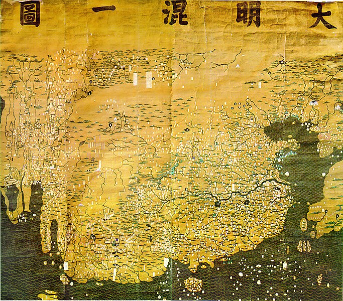
| 描述 | The Composite Map of the Ming Empire (Da Ming Hunyi Tu) reflects the political situation in AD 1389 but was likely painted much later. Original Chinese labels were later covered with Manchu on paper slips. |
| 日期 | 在1389年之后 |
| 来源 | http://geog.hkbu.edu.hk/GEOG1150/Chinese/Catalog/am31_map1.htm |
| 作者 | Chinese (image enhanced by contributor) |
许可协议[编辑]
|
这是一个平面公有领域艺术品的忠实摄影副本。原艺术品本身因为下列原因属于公有领域:
维基媒体基金会的官方立场认为:“对平面公有领域艺术品的忠实再制作品也属于公有领域。”
因此,可以认为此摄影副本在美国也属于公有领域。在其他司法管辖区,再利用此内容可能存在限制;参见再利用PD-Art照片了解详细信息。 | ||||
文件历史
点击某个日期/时间查看对应时刻的文件。
| 日期/时间 | 缩略图 | 大小 | 用户 | 备注 | |
|---|---|---|---|---|---|
| 当前 | 2008年3月17日 (一) 01:14 | | 895 × 786(493 KB) | David Trochos(留言 | 贡献) | {{Information |Description=The Da Ming Hun Yi Tu (Great Ming Dynasty Amalagamated Map), painted on silk in AD 1389 but with Manchu language captions superimposed on paper slips several centuries later, is the oldest surviving Chinese world map. |Source= h |
| 2008年3月16日 (日) 22:54 |  | 895 × 786(487 KB) | David Trochos(留言 | 贡献) | {{Information |Description=The Da Ming Hun Yi Tu (Great Ming Dynasty Amalagamated Map), painted on silk in AD 1389 but with Manchu language captions superimposed on paper slips several centuries later, is the oldest surviving Chinese world map. |Source= h |
您不可以覆盖此文件。
文件用途
以下2个页面使用本文件:
全域文件用途
以下其他wiki使用此文件:
- bn.wikipedia.org上的用途
- de.wikipedia.org上的用途
- en.wikipedia.org上的用途
- es.wikipedia.org上的用途
- fa.wikipedia.org上的用途
- fa.wikibooks.org上的用途
- fr.wikipedia.org上的用途
- hr.wikipedia.org上的用途
- id.wikipedia.org上的用途
- it.wikipedia.org上的用途
- ja.wikipedia.org上的用途
- ko.wikipedia.org上的用途
- sl.wikipedia.org上的用途
- ur.wikipedia.org上的用途
- www.wikidata.org上的用途
- zh.wikipedia.org上的用途