File:Dakotatribesmap.jpg
Skočit na navigaci
Skočit na vyhledávání
Velikost tohoto náhledu: 800 × 583 pixelů. Jiná rozlišení: 320 × 233 pixelů | 640 × 466 pixelů | 891 × 649 pixelů.
Původní soubor (891 × 649 pixelů, velikost souboru: 212 KB, MIME typ: image/jpeg)
Popisky
Popisky
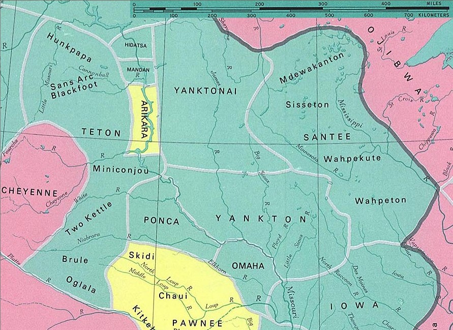
Území siouxských a sousedních kmenů (verzálky) a podkmenů ca v 1. pol. 19. stol. Tmavá čára vyznačuje hranici mezi kult. oblastmi. Jazykové skup.: siouxská zeleně (ne všechny kmeny patří k siouxskému národu), algonkinská růžově a kaddoská žlutě
Dakota tribes
fragment from: http://www.lib.utexas.edu/maps/national_atlas_1970/ca000097.jpg
Most of the maps scanned by the University of Texas Libraries and served from this web site are in the public domain. No permissions are needed to copy them. You may download them and use them as you wish.
This file is in the public domain because Most of the maps scanned by the University of Texas Libraries and served from this web site (www.lib.utexas.edu) are in the public domain. No permissions are needed to copy them. You may download them and use them as you wish.
|
also see

Historie souboru
Kliknutím na datum a čas se zobrazí tehdejší verze souboru.
| Datum a čas | Náhled | Rozměry | Uživatel | Komentář | |
|---|---|---|---|---|---|
| současná | 10. 1. 2006, 23:37 | | 891 × 649 (212 KB) | Pitert (diskuse | příspěvky) | Dakota tribes fragment from: http://www.lib.utexas.edu/maps/national_atlas_1970/ca000097.jpg {{PD}} |
Tento soubor nemůžete přepsat.
Využití souboru
Na Commons na soubor odkazuje tato stránka:
Globální využití souboru
Tento soubor využívají následující wiki:
- Využití na ca.wikipedia.org
- Využití na cs.wikipedia.org
- Využití na es.wikipedia.org
- Využití na fi.wikipedia.org
- Využití na fr.wikipedia.org
- Využití na ja.wikipedia.org
- Využití na pl.wikipedia.org