File:Danubemap.png
Μετάβαση στην πλοήγηση
Πήδηση στην αναζήτηση
Δεν διατίθεται υψηλότερη ανάλυση.
Danubemap.png (747 × 480 εικονοστοιχεία, μέγεθος αρχείου: 601 KB, τύπος MIME: image/png)
Λεζάντες
Λεζάντες
Δεν ορίστηκε λεζάντα
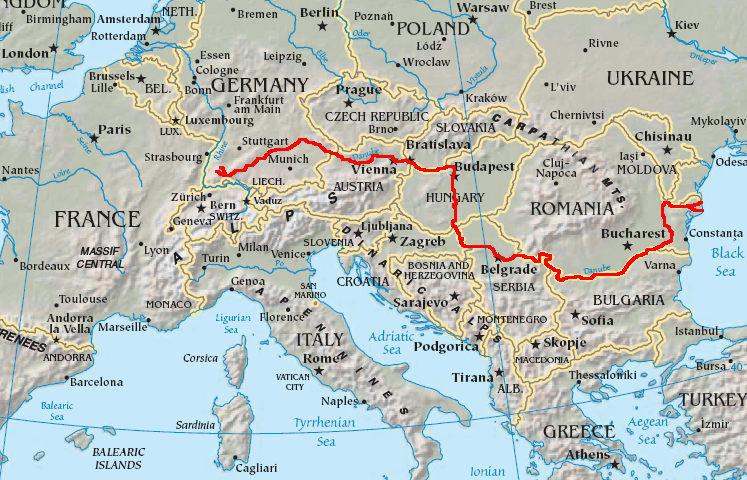
Path of the Danube

|
This map image could be re-created using vector graphics as an SVG file. This has several advantages; see Commons:Media for cleanup for more information. If an SVG form of this image is available, please upload it and afterwards replace this template with
{{vector version available|new image name}}.
It is recommended to name the SVG file “Danubemap.svg”—then the template Vector version available (or Vva) does not need the new image name parameter. |
Σύνοψη
[επεξεργασία]
English: Map showing the flow of the Danube River. Uses the map of Europe from the CIA World Factbook.
Αδειοδότηση
[επεξεργασία]
This image is in the public domain because it contains materials that originally came from the United States Central Intelligence Agency's World Factbook.
|
 |
Ιστορικό αρχείου
Πατήστε σε μια ημερομηνία/ώρα για να δείτε το αρχείο όπως εμφανιζόταν εκείνη την χρονική στιγμή.
| Ημερομηνία/Ώρα | Μικρογραφία | Διαστάσεις | Χρήστης | Σχόλιο | |
|---|---|---|---|---|---|
| τρέχον | 05:34, 12 Φεβρουαρίου 2007 | | 747 × 480 (601 KB) | Geologik (συζήτηση | Συνεισφορά) | Map showing the flow of the Danube River. Uses the map of Europe from the CIA World Factbook. |
Δεν μπορείτε να αντικαταστήσετε αυτό το αρχείο.
Χρήση αρχείου
Οι ακόλουθες 4 σελίδες χρησιμοποιούν προς αυτό το αρχείο:
Καθολική χρήση αρχείου
Τα ακόλουθα άλλα wiki χρησιμοποιούν αυτό το αρχείο:
- Χρήση σε ang.wikipedia.org
- Χρήση σε ast.wikipedia.org
- Χρήση σε av.wikipedia.org
- Χρήση σε azb.wikipedia.org
- Χρήση σε ban.wikipedia.org
- Χρήση σε be-tarask.wikipedia.org
- Χρήση σε bg.wikipedia.org
Δείτε περισσότερη καθολική χρήση αυτού του αρχείου.