File:Dao Niger and Harmakhis Vallis PIA02810.jpg
Ir a la navegación
Ir a la búsqueda

Tamaño de esta previsualización: 800 × 519 píxeles. Otras resoluciones: 320 × 208 píxeles | 640 × 415 píxeles | 1024 × 664 píxeles | 1280 × 830 píxeles | 1637 × 1062 píxeles.
Archivo original (1637 × 1062 píxeles; tamaño de archivo: 168 kB; tipo MIME: image/jpeg)
Leyendas
Leyendas
Añade una explicación corta acerca de lo que representa este archivo
Resumen
[editar]
| Descripción |
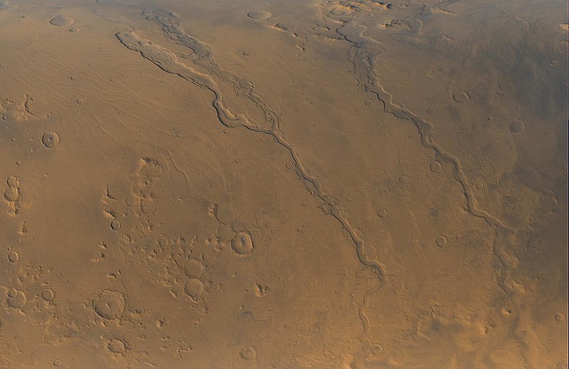
English: The Mars Global Surveyor (MGS) Mars Orbiter Camera (MOC) opened its fourth year orbiting the red planet with this mid-autumn view of three major valley systems east of the Hellas plains. From left to right, the first major valley, Dao Vallis, runs diagonally from the upper left to just past the lower center of the image. Niger Vallis joins Dao Vallis just above the center of the frame. Harmakhis Vallis extends diagonally across the right half of the picture, toward the lower right. These valleys are believed by some to have been formed--at least in part--by large outbursts of liquid water some time far back in the martian past, though there is no way to know exactly how many hundreds of millions or billions of years ago this might have occurred. In each valley, water would have flowed toward the bottom of the image. Although their dimensions vary along their courses, the valleys are all roughly 1 km (0.6 miles) deep and range in width from about 40 km (25 miles) down to about 8 km (5 mi). Located around 40°S, 270°W, the picture covers an area approximately 800 km across and is illuminated by sunlight from the lower left. North is toward the left; the picture is a composite of red and blue wide angle images obtained by MOC on September 13, 2000, |
| Fuente | http://photojournal.jpl.nasa.gov/catalog/PIA02810 |
| Autor | NASA/JPL/MSSS |
Licencia
[editar]
| Este archivo es de dominio público porque fue creado por la NASA. Las políticas sobre copyright de la NASA estipulan que «el material de la NASA no está protegido con copyright a menos que se indique lo contrario». (Políticas sobre copyright de la NASA o Políticas sobre la utilización de imágenes del Jet Propulsion Laboratory). | ||
 |
Advertencias:
|
Historial del archivo
Haz clic sobre una fecha y hora para ver el archivo tal como apareció en ese momento.
| Fecha y hora | Miniatura | Dimensiones | Usuario | Comentario | |
|---|---|---|---|---|---|
| actual | 06:55 12 abr 2008 | | 1637 × 1062 (168 kB) | Bryan Derksen (discusión | contribs.) | {{Information |Description={{en| The Mars Global Surveyor (MGS) Mars Orbiter Camera (MOC) opened its fourth year orbiting the red planet with this mid-autumn view of three major valley systems east of the Hellas plains. From left to right, the first ma |
No puedes sobrescribir este archivo.
Usos del archivo
Las siguientes páginas usan este archivo:
Uso global del archivo
Las wikis siguientes utilizan este archivo:
- Uso en ca.wikipedia.org
- Uso en cs.wikipedia.org
- Uso en en.wikipedia.org
- Uso en es.wikipedia.org
- Uso en fr.wikipedia.org
- Uso en it.wikipedia.org
- Uso en ja.wikipedia.org
- Uso en pl.wikipedia.org
- Uso en pt.wikipedia.org
- Uso en uk.wikipedia.org
- Uso en www.wikidata.org
- Uso en zh.wikipedia.org