File:Darcha Padum Road Below Shinku La Lahaul Oct22 A7C 03533.jpg
跳至導覽
跳至搜尋

預覽大小:800 × 533 像素。 其他解析度:320 × 213 像素 | 640 × 427 像素 | 1,024 × 683 像素 | 1,280 × 853 像素 | 2,560 × 1,707 像素 | 6,000 × 4,000 像素。
原始檔案 (6,000 × 4,000 像素,檔案大小:20.05 MB,MIME 類型:image/jpeg)
說明
說明
添加單行說明來描述出檔案所代表的內容
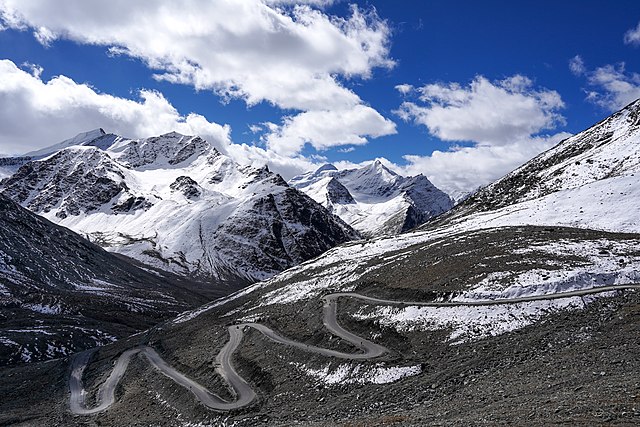
Darcha-Padum road winding up to Shinku La, Lahaul, Himachal, India. Elev. 4,975m (16,322'). 4 Oct 2022
摘要
[編輯]| 描述 |
English: Darcha-Padum road winding up to Shinku La, Lahaul, Himachal, India. Elev. 4,975m (16,322'). Peaks about 5,600m (18,375').
Español: El sinuoso camino a Shingo La, un paso montañoso del Himalaya de 5090 m de altura en el norte de India, que conecta la región de Lahaul en Himachal Pradesh con la región de Zanskar en Ladakh.
Українська: Звивиста дорога до Шінго Ла, гімалайського гірського перевалу висотою 5091 м на півночі Індії, що з’єднує регіон Лахаул у Гімачал-Прадеші з регіоном Занскар у Ладакху. |
|||
| 日期 | ||||
| 來源 | 自己的作品 | |||
| 作者 |
|

| 拍攝地點 | | 位於此地的本圖片與其他圖片: OpenStreetMap |
|---|
評價
[編輯]
|
This image was selected as picture of the day on Wikimedia Commons for 6 October 2023. It was captioned as follows: English: The winding road to Shingo La, a 5,090 m (16,700 ft) Himalayan mountain pass in northern India connecting the Lahaul region of Himachal Pradesh with the Zanskar region of Ladakh. Other languages:
Čeština: Klikatící se horská silnice k horskému přechodu Shingo La v nadmořské výšce 5 090 m n. m. v himálajské části severní Indie spojuje oblast Lahaul and Spiti district a Ladak. Deutsch: Die Straße zum Shingo La, einem 5.090 m hohen Gebirgspass im Himalaya. English: The winding road to Shingo La, a 5,090 m (16,700 ft) Himalayan mountain pass in northern India connecting the Lahaul region of Himachal Pradesh with the Zanskar region of Ladakh. Español: El sinuoso camino a Shingo La, un paso montañoso del Himalaya de 5090 m de altura en el norte de India, que conecta la región de Lahaul en Himachal Pradesh con la región de Zanskar en Ladakh. Français : Route sinueuse de l'Himalaya menant vers le passage de Shingo La situé à 5 090 m, et reliant le district de Lahaul et Spiti à Zanskar, en Inde. Magyar: Kanyargós út a Singo Lán, az 5090 méter magas himalájai hágón Észak-Indiában, amely a Himácsal Prades tartománybeli Lahaul régiót köti össze a ladaki Zanszkár régióval Nederlands: Haarspeldbochten in de weg naar Shingo La, een bergpas op 5090 meter hoogte die Lahul en Zanskar in het noorden van India met elkaar verbindt Português: Estrada sinuosa para Shingo La, uma passagem de 5 090 m na montanha do Himalaia, no norte da Índia, que conecta a região de Lahaul, em Himachal Pradesh, com a região de Zanskar, em Ladakh. Slovenščina: Vijugasta cesta do Šingo Laja, 5090 metrov visokega himalajskega gorskega prelaza na severu Indije, ki povezuje pokrajino Lahaul v Himačal Pradešu s pokrajino Zanskar v Ladaku. Українська: Звивиста дорога до Шінго Ла, гімалайського гірського перевалу висотою 5091 м на півночі Індії, що з’єднує регіон Лахаул у Гімачал-Прадеші з регіоном Занскар у Ладакху. বাংলা : উইন্ডিং রাস্তা থেকে লিঙ্গো লা, উত্তর ভারতের 5,090 m (16,700 ft) বিস্তৃত হিমালায়ন গিরিপথ, যা লাদাখের জান্সকার অঞ্চলের সাথে হিমাচল প্রদেশের লাহৌল অঞ্চলকে সংযুক্ত করেছে। |
授權條款
[編輯]
我,本作品的著作權持有者,決定用以下授權條款發佈本作品:
此檔案採用共享創意 姓名標示-相同方式分享 4.0 國際授權條款。
- 您可以自由:
- 分享 – 複製、發佈和傳播本作品
- 重新修改 – 創作演繹作品
- 惟需遵照下列條件:
- 姓名標示 – 您必須指名出正確的製作者,和提供授權條款的連結,以及表示是否有對內容上做出變更。您可以用任何合理的方式來行動,但不得以任何方式表明授權條款是對您許可或是由您所使用。
- 相同方式分享 – 如果您利用本素材進行再混合、轉換或創作,您必須基於如同原先的相同或兼容的條款,來分布您的貢獻成品。
檔案歷史
點選日期/時間以檢視該時間的檔案版本。
| 日期/時間 | 縮圖 | 尺寸 | 用戶 | 備註 | |
|---|---|---|---|---|---|
| 目前 | 2022年10月18日 (二) 05:07 | | 6,000 × 4,000(20.05 MB) | Tagooty(對話 | 貢獻) | Uploaded own work with UploadWizard |
無法覆蓋此檔案。
檔案用途
下列38個頁面有用到此檔案:
- Himachal Pradesh
- User:Andrew J.Kurbiko/POTD/2023
- User:Kacamata/Favorites
- User:UnpetitproleX/POTD
- User:Velopilger/2022, 18. Oktober
- User:Yasir72.multan/POTD Year
- User talk:Tagooty/Archive of User talk:Tagooty 13 Aug 2023 to 30 Nov 2023
- User talk:Tagooty/Archive of User talk:Tagooty 17 Oct 2022 to 31 Mar 2023
- Commons:Featured picture candidates/File:Darcha Padum Road Below Shinku La Lahaul Oct22 A7C 03533.jpg
- Commons:Featured picture candidates/Log/October 2022
- Commons:Featured pictures/Places/Other
- Commons:Featured pictures/chronological/2022-B
- Commons:Featured pictures/chronological/October 2022
- Commons:Files used on the AARoads Wiki/22
- Commons:Picture of the Year/2022/Candidates
- Commons:Picture of the Year/2022/R1/Gallery/2022-B
- Commons:Picture of the Year/2022/R1/Gallery/ALL
- Commons:Picture of the Year/2022/R1/Gallery/M10
- Commons:Picture of the Year/2022/R1/Gallery/Nature views
- Commons:Picture of the Year/2022/R1/v/Darcha Padum Road Below Shinku La Lahaul Oct22 A7C 03533.jpg
- Commons:Quality images/Subject/Places/Natural structures/archive 2022
- Commons:Quality images candidates/Archives October 22 2022
- File:Darcha Padum Road Below Shinku La Lahaul Oct22 A7C 03533.jpg
- Template:Potd/2023-10
- Template:Potd/2023-10-06
- Template:Potd/2023-10-06 (cs)
- Template:Potd/2023-10-06 (de)
- Template:Potd/2023-10-06 (en)
- Template:Potd/2023-10-06 (es)
- Template:Potd/2023-10-06 (fr)
- Template:Potd/2023-10-06 (hu)
- Template:Potd/2023-10-06 (mk)
- Template:Potd/2023-10-06 (myv)
- Template:Potd/2023-10-06 (nl)
- Template:Potd/2023-10-06 (pt)
- Template:Potd/2023-10-06 (sl)
- Template:Potd/2023-10-06 (uk)
- Category:Nimmu–Padum–Darcha road
全域檔案使用狀況
以下其他 wiki 使用了這個檔案:
- alt.wikipedia.org 的使用狀況
- av.wikipedia.org 的使用狀況
- bn.wikipedia.org 的使用狀況
- cv.wikipedia.org 的使用狀況
- de.wikipedia.org 的使用狀況
- en.wikipedia.org 的使用狀況
- Mountain pass
- Wikipedia:WikiProject Highways
- Shingo La
- Wikipedia:Featured pictures/Places/Others
- Wikipedia:WikiProject Military history/Showcase
- Wikipedia:WikiProject Military history/Showcase/FP
- Wikipedia:WikiProject India/Recognized content
- Wikipedia:WikiProject India/Main page featured content
- Wikipedia:WikiProject Highways/Recognized content
- Wikipedia:WikiProject Military history/Indian military history task force
- Wikipedia:WikiProject Military history/Featured content
- User:Tagooty
- User talk:Tagooty
- India–China Border Roads
- Nimmu–Padum–Darcha road
- Portal:History/Recognized content
- Portal:India/Recognized content
- Wikipedia:WikiProject Mountains/Recognized content
- User talk:UnpetitproleX
- Wikipedia:Picture of the day/May 2023
- Wikipedia:Featured pictures thumbs/75
- Wikipedia:Featured picture candidates/December-2022
- Wikipedia:Featured picture candidates/Shingo La road
- Wikipedia:Wikipedia Signpost/2023-01-16/Featured content
- Wikipedia:Wikipedia Signpost/Single/2023-01-16
- Template:POTD/2023-05-04
- User:UnpetitproleX/POTD
- Wikipedia:Main Page history/2023 May 4
- Wikipedia:Main Page history/2023 May 4b
- et.wikipedia.org 的使用狀況
- hu.wikipedia.org 的使用狀況
- it.wiktionary.org 的使用狀況
- kk.wikipedia.org 的使用狀況
- ko.wikipedia.org 的使用狀況
- lez.wikipedia.org 的使用狀況
- mk.wikipedia.org 的使用狀況
- os.wikipedia.org 的使用狀況
- pt.wikipedia.org 的使用狀況
- ru.wikipedia.org 的使用狀況
- sah.wikipedia.org 的使用狀況
- sv.wikipedia.org 的使用狀況
- te.wikipedia.org 的使用狀況
- uk.wikipedia.org 的使用狀況
檢視此檔案的更多全域使用狀況。