File:Daytona International Speedway.svg
跳至導覽
跳至搜尋

此 SVG 檔案的 PNG 預覽的大小:800 × 428 像素。 其他解析度:320 × 171 像素 | 640 × 343 像素 | 1,024 × 548 像素 | 1,280 × 685 像素 | 2,560 × 1,371 像素 | 1,255 × 672 像素。
原始檔案 (SVG 檔案,表面大小:1,255 × 672 像素,檔案大小:34 KB)
說明
說明
添加單行說明來描述出檔案所代表的內容
摘要
[編輯]| 描述 |
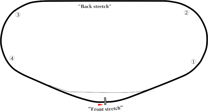
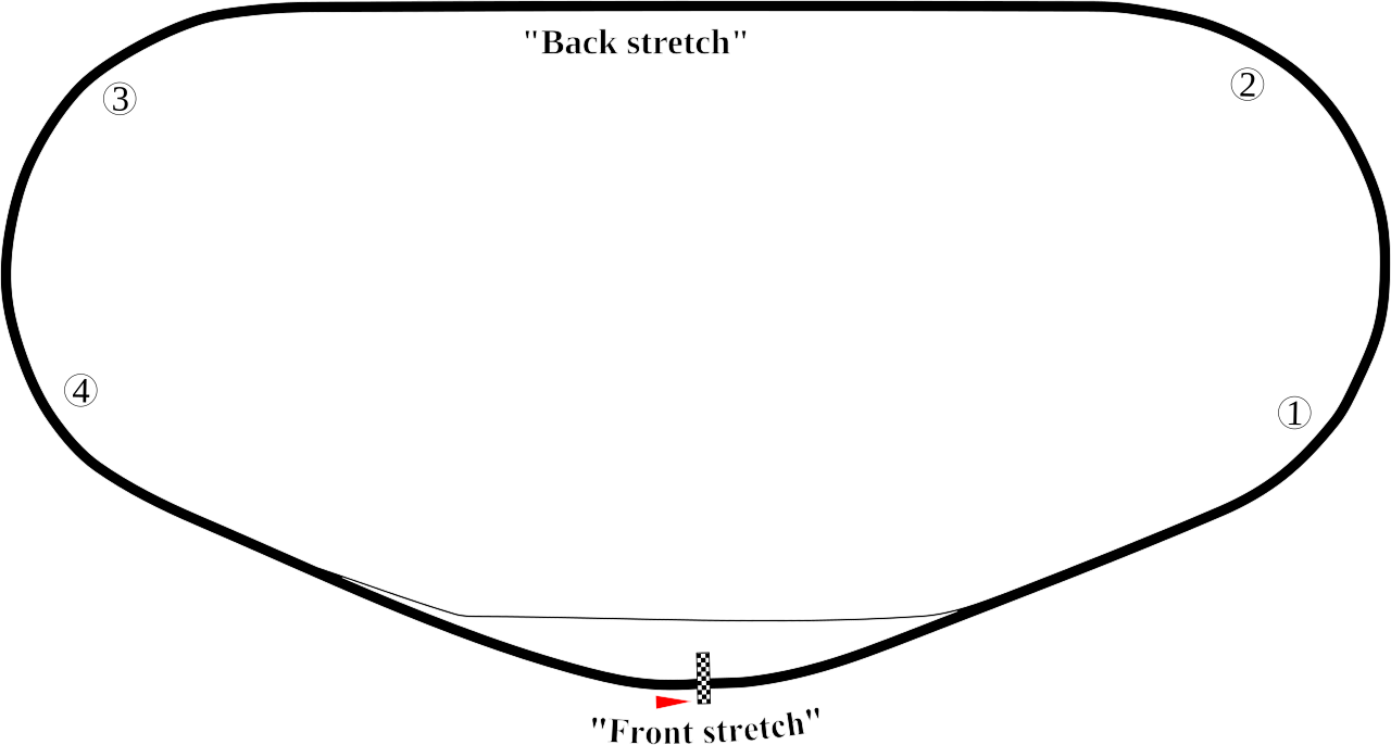
English: Track map of Daytona International Speedway showing mainly the speedway. |
| 日期 | 7-8-2008 |
| 來源 | 自己的作品 |
| 作者 | Will Pittenger |
| 其他版本 |
|


| 拍攝地點 | | 位於此地的本圖片與其他圖片: OpenStreetMap |
|---|
授權條款
[編輯]
| 我,此作品的版權所有人,釋出此作品至公共領域。此授權條款在全世界均適用。 這可能在某些國家不合法,如果是的話: 我授予任何人有權利使用此作品於任何用途,除受法律約束外,不受任何限制。 |
檔案歷史
點選日期/時間以檢視該時間的檔案版本。
| 日期/時間 | 縮圖 | 尺寸 | 用戶 | 備註 | |
|---|---|---|---|---|---|
| 目前 | 2008年7月8日 (二) 10:30 | | 1,255 × 672(34 KB) | Will Pittenger(對話 | 貢獻) | This version gets around the Mediawiki bug that hides text on path objects by converting them to ordinary objects. If you need to edit the text in those objects, please use the previous version. They are the same in all other aspects. |
| 2008年7月8日 (二) 10:16 |  | 1,255 × 672(18 KB) | Will Pittenger(對話 | 貢獻) | {{Information |Description={{en|1=Track map of w:Daytona International Speedway showing mainly the speedway.}} |Source=Own work by uploader |Author=Will Pittenger |Date=7-8-2008 |Permission= |other_versions=[[Image:Daytona Int |
無法覆蓋此檔案。
檔案用途
下列5個頁面有用到此檔案:
全域檔案使用狀況
以下其他 wiki 使用了這個檔案:
- ast.wikipedia.org 的使用狀況
- de.wikipedia.org 的使用狀況
- en.wikipedia.org 的使用狀況
- Daytona 500
- Daytona International Speedway
- List of NASCAR tracks
- Bluegreen Vacations Duel
- Tri-oval
- Oval track racing
- Fresh From Florida 250
- Daytona 300
- 1990 Daytona 500
- Wawa 250
- 2000 Daytona 500
- 1987 Daytona 500
- 1991 Daytona 500
- 1992 Daytona 500
- 1993 Daytona 500
- 2007 Pepsi 400
- Coke Zero Sugar 400
- Hard Rock Bet 200
- 1959 Daytona 500
- List of auto racing tracks in the United States
- 1986 Daytona 500
- 1989 Daytona 500
- 1988 Daytona 500
- 2009 Budweiser Shootout
- List of Daytona 500 pole position winners
- 2010 Daytona 500
- 2009 Coke Zero 400
- List of NASCAR fatalities
- 1980 Firecracker 400
- 2011 Daytona 500
- 2011 Budweiser Shootout
- 2011 Gatorade Duels
- 1986 Firecracker 400
- 2011 Coke Zero 400
- 2012 Daytona 500
- 2012 Budweiser Shootout
- 2012 Gatorade Duels
- 1999 Pepsi 400
- 1998 Pepsi 400
- 2012 Coke Zero 400
- 2013 Sprint Unlimited
- 2013 Daytona 500
- 2004 Pepsi 400
- 2000 Daytona 250
檢視此檔案的更多全域使用狀況。