File:DeSoto Map Leg 2 HRoe 2008.jpg
Aller à la navigation
Aller à la recherche
Pas de plus haute résolution disponible.
DeSoto_Map_Leg_2_HRoe_2008.jpg (600 × 470 pixels, taille du fichier : 290 kio, type MIME : image/jpeg)
Légendes
Légendes
Ajoutez en une ligne la description de ce que représente ce fichier
Description
[modifier]
| Description |
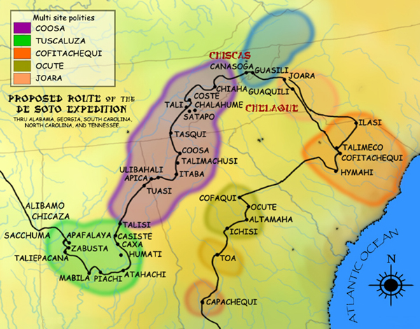
English: A map showing the de Soto expedition route through the future U.S. states of Georgia, South Carolina, North Carolina, Tennessee, and Alabama. Based on the Charles M. Hudson map of 1997. |
| Date |
20 septembre 2008 (date de téléversement originale) |
| Source | Travail personnel (Texte original : I created this work entirely by myself.) |
| Auteur | Heironymous Rowe (talk) |
Conditions d’utilisation
[modifier]
Heironymous Rowe sur Wikipédia anglais, en tant que détenteur des droits d’auteur sur cette œuvre, la publie sous les licences suivantes :
Ce fichier est disponible selon les termes de la licence Creative Commons Attribution – Partage dans les Mêmes Conditions 3.0 (non transposée).
Attribution: Heironymous Rowe sur Wikipédia anglais
- Vous êtes libre :
- de partager – de copier, distribuer et transmettre cette œuvre
- d’adapter – de modifier cette œuvre
- Sous les conditions suivantes :
- paternité – Vous devez donner les informations appropriées concernant l'auteur, fournir un lien vers la licence et indiquer si des modifications ont été faites. Vous pouvez faire cela par tout moyen raisonnable, mais en aucune façon suggérant que l’auteur vous soutient ou approuve l’utilisation que vous en faites.
- partage à l’identique – Si vous modifiez, transformez, ou vous basez sur cette œuvre, vous devez distribuer votre contribution sous la même licence ou une licence compatible avec celle de l’original.

|
Vous avez la permission de copier, distribuer et modifier ce document selon les termes de la GNU Free Documentation License version 1.2 ou toute version ultérieure publiée par la Free Software Foundation, sans sections inaltérables, sans texte de première page de couverture et sans texte de dernière page de couverture. Un exemplaire de la licence est inclus dans la section intitulée GNU Free Documentation License. |
Vous pouvez choisir l’une de ces licences.
Journal des téléversements d’origine
[modifier]
Transféré de en.wikipedia à Commons par Dmitri Lytov utilisant CommonsHelper.
La page de description originale était ici. Tous les noms d'utilisateur qui suivent se rapportent à en.wikipedia.
- 2008-09-20 02:14 Heironymous Rowe 610×480× (315397 bytes) {{Information |Description=A map showing the Hernando de Soto|de Soto]] expedition route thru [[Georgia]], [[South Carolina]], [[North Carolina]], [[Tennessee]], and [[Alabama]]. Based on the [[Charles M. Hudson (author)|Charles M. Hudson]] map of 1997. |
Historique du fichier
Cliquer sur une date et heure pour voir le fichier tel qu'il était à ce moment-là.
| Date et heure | Vignette | Dimensions | Utilisateur | Commentaire | |
|---|---|---|---|---|---|
| actuel | 22 juin 2010 à 22:11 | | 600 × 470 (290 kio) | Ras67 (d | contributions) | cropped, watermark removed |
| 1 mars 2009 à 07:42 |  | 610 × 480 (308 kio) | File Upload Bot (Magnus Manske) (d | contributions) | {{BotMoveToCommons|en.wikipedia|year={{subst:CURRENTYEAR}}|month={{subst:CURRENTMONTHNAME}}|day={{subst:CURRENTDAY}}}} {{Information |Description={{en|A map showing the de Soto expedition route thru [[:en:Georgia (U.S. state)|Geo |
Vous ne pouvez pas remplacer ce fichier.
Utilisations locales du fichier
Aucune page n’utilise ce fichier.
Utilisations du fichier sur d’autres wikis
Les autres wikis suivants utilisent ce fichier :
- Utilisation sur af.wikipedia.org
- Utilisation sur bg.wikipedia.org
- Utilisation sur ca.wikipedia.org
- Utilisation sur de.wikipedia.org
- Utilisation sur en.wikipedia.org
- Utilisation sur fi.wikipedia.org
- Utilisation sur fr.wikipedia.org
- Utilisation sur it.wikipedia.org
- Utilisation sur ja.wikipedia.org
- Utilisation sur simple.wikipedia.org
- Utilisation sur www.wikidata.org
Métadonnées
Catégories :
- Maps showing history of indigenous peoples of North America
- Maps of the history of the United States
- Mississippian culture maps and diagrams
- Archaeological sites in the United States
- Maps of the history of North Carolina
- Forts in North Carolina
- Maps of the history of South Carolina
- Hernando de Soto's expedition in North America
- 16th-century maps of the United States
- History of indigenous peoples of the Southeastern United States
- Indigenous peoples of the Southeastern Woodlands
- Native American history of Georgia (U.S. state)
- Native American history of South Carolina
- Native American history of North Carolina
- Native American history of Tennessee
- Native American history of Alabama
- Maps of the history of Tennessee
- Maps of the history of Georgia (U.S. state)
- Georgia (U.S. state) in the 16th century
- South Carolina in the 16th century
- Tennessee in the 16th century
- Alabama in the 16th century
- North Carolina in the 16th century
- Mabila
- Talisi (Muscogee town)
- Native American villages and towns
- Joara
- Cheraw
- Chickasaw maps
- Cherokee maps
- Muscogee maps
- Coosa chiefdom